Hettinger, North Dakota facts for kids
Quick facts for kids
Hettinger, North Dakota
|
|
|---|---|

Hettinger
|
|

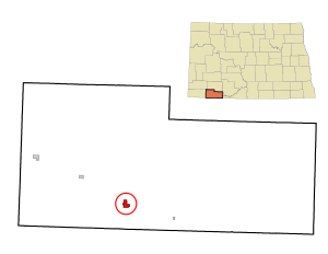
Location of Hettinger, North Dakota
|
|
| Country | United States |
| State | North Dakota |
| County | Adams |
| Founded | 1907 |
| Incorporated | 1908 |
| Area | |
| • Total | 0.86 sq mi (2.22 km2) |
| • Land | 0.83 sq mi (2.15 km2) |
| • Water | 0.03 sq mi (0.08 km2) |
| Elevation | 2,740 ft (835 m) |
| Population
(2020)
|
|
| • Total | 1,074 |
| • Estimate
(2022)
|
1,029 |
| • Density | 1,295.54/sq mi (500.16/km2) |
| Time zone | UTC-7 (Mountain (MST)) |
| • Summer (DST) | UTC-6 (MDT) |
| ZIP code |
58639
|
| Area code(s) | 701 |
| FIPS code | 38-37700 |
| GNIS feature ID | 1036091 |
| Highways | US 12, ND 8 |
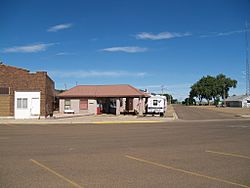
Hettinger is a city located in Adams County, North Dakota, in the United States. It is also the county seat, which means it's where the local government offices are. In 2020, about 1,074 people lived there.
Near Hettinger, North Dakota State University has a special farm for studying livestock, like cows and sheep. They often work with South Dakota State University on research, especially about sheep.
Contents
History of Hettinger
Hettinger was started in 1907. It was built along a major railroad line called the Milwaukee Road's Pacific Extension. People wanted the city and its nearby area to be named after Hettinger County, North Dakota. This is because Adams County was created from Hettinger County in the same year, 1907.
In 1923, a strong windstorm (a tornado) hit an area east of Hettinger. It destroyed a farm and sadly, two people lost their lives.
Geography and Climate
Hettinger covers a total area of about 0.86 square miles (2.22 square kilometers). Most of this area is land, with only a small part being water.
Hettinger's Climate
Hettinger has a semi-arid climate. This means it's usually dry, but not a desert. It gets more rain than a desert, but less than a humid area.
Population and People
| Historical population | |||
|---|---|---|---|
| Census | Pop. | %± | |
| 1910 | 766 | — | |
| 1920 | 817 | 6.7% | |
| 1930 | 1,292 | 58.1% | |
| 1940 | 1,138 | −11.9% | |
| 1950 | 1,762 | 54.8% | |
| 1960 | 1,769 | 0.4% | |
| 1970 | 1,655 | −6.4% | |
| 1980 | 1,739 | 5.1% | |
| 1990 | 1,574 | −9.5% | |
| 2000 | 1,307 | −17.0% | |
| 2010 | 1,226 | −6.2% | |
| 2020 | 1,074 | −12.4% | |
| 2022 (est.) | 1,029 | −16.1% | |
| U.S. Decennial Census 2020 Census |
|||
Population in 2010
In 2010, there were 1,226 people living in Hettinger. They lived in 587 homes, and 316 of these were families. The city had about 1,442 people per square mile.
Most of the people in Hettinger were White (97.4%). A small number were African American, Native American, or Asian. Some people were from two or more racial backgrounds. About 0.9% of the population identified as Hispanic or Latino.
About 22.8% of homes had children under 18 living there. Many homes (43.6%) were married couples. About 42.9% of homes were single people living alone. The average age in Hettinger was 48 years old.
Education in Hettinger
The main school in the city is Hettinger High School.
Local Media
Hettinger has two local radio stations: KNDC and KZRH.
Famous People from Hettinger
Some notable people who have connections to Hettinger include:
- Rick Berg, who served as a U.S. Congressman.
- Patrick Daniel Norton, another U.S. Congressman.
- Steve Tomac, who was a state legislator in North Dakota.
See also
 In Spanish: Hettinger (Dakota del Norte) para niños
 | Isaac Myers |
 | D. Hamilton Jackson |
 | A. Philip Randolph |

