
Stark County, North Dakota facts for kids
Quick facts for kids
Stark County
|
|
|---|---|

Stark County Courthouse in Dickinson
|
|

Location within the U.S. state of North Dakota
|
|
 North Dakota's location within the U.S. |
|
| Country | |
| State | |
| Founded | February 10, 1879 (created) May 25, 1883 (organized) |
| Named for | George Stark |
| Seat | Dickinson |
| Largest city | Dickinson |
| Area | |
| • Total | 1,340 sq mi (3,500 km2) |
| • Land | 1,335 sq mi (3,460 km2) |
| • Water | 5.5 sq mi (14 km2) 0.4% |
| Population
(2020)
|
|
| • Total | 33,646 |
| • Estimate
(2023)
|
33,001 |
| • Density | 25.11/sq mi (9.69/km2) |
| Time zone | UTC−7 (Mountain) |
| • Summer (DST) | UTC−6 (MDT) |
| Congressional district | At-large |
Stark County is a county located in the state of North Dakota in the United States. In 2020, about 33,646 people lived here. This makes it the 7th largest county in North Dakota by population. The main city and county seat is Dickinson.
Stark County is part of the Dickinson, ND Micropolitan Statistical Area. This means it's a smaller city area that is connected to a larger city.
Contents
History of Stark County
The area that is now Stark County was first created on February 10, 1879. This happened when the government of the Dakota Territory decided to form new counties. They used land from other areas that no longer exist today.
The county was named after George Stark. He was an important person who worked for the Northern Pacific Railroad. Even though the county was created, it wasn't fully set up with its own government until May 25, 1883.
Over the years, the county's borders changed a few times. In 1883, some land was used to create Hettinger County. Then, in 1887, the borders were changed again. Finally, in 1908, a small piece of land was added. This gave Stark County the exact shape it has today.
Geography and Nature
The Heart River flows through the middle of Stark County. It goes into Patterson Lake in Dickinson. From there, it continues east into Morton County.
The land in Stark County has rolling hills. It is mostly used for farming. The highest point in the county is about 2,831 feet (863 meters) above sea level. This is near the southwest corner. The county covers a total area of 1,340 square miles (3,471 square kilometers). Most of this is land, with only a small part being water.
Stark County is in the Mountain Time Zone. This means the clocks are set to Mountain Time. Other counties in southwestern North Dakota also use this time zone.
Main Roads in Stark County
- I-94
- US 85
- ND 8
- ND 22
Public Transport
- Jefferson Lines (a bus service)
Neighboring Counties
- Dunn County - to the north
- Mercer County - to the northeast
- Morton County - to the east
- Grant County - to the southeast
- Hettinger County - to the south
- Slope County - to the southwest
- Billings County - to the west
Lakes in Stark County
- Abbey Lake
- Patterson Lake
People and Population
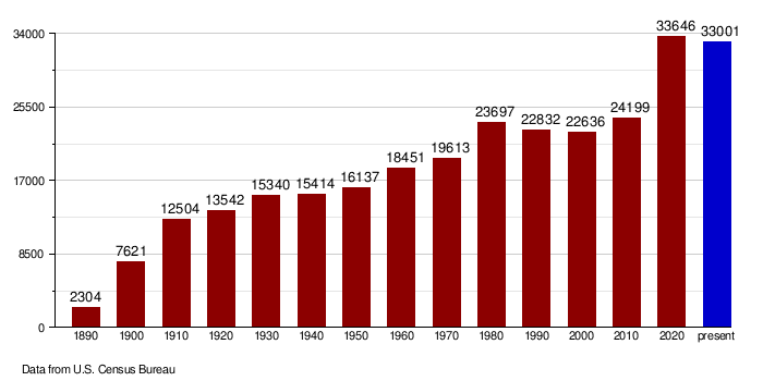
| Historical population | |||
|---|---|---|---|
| Census | Pop. | %± | |
| 1890 | 2,304 | — | |
| 1900 | 7,621 | 230.8% | |
| 1910 | 12,504 | 64.1% | |
| 1920 | 13,542 | 8.3% | |
| 1930 | 15,340 | 13.3% | |
| 1940 | 15,414 | 0.5% | |
| 1950 | 16,137 | 4.7% | |
| 1960 | 18,451 | 14.3% | |
| 1970 | 19,613 | 6.3% | |
| 1980 | 23,697 | 20.8% | |
| 1990 | 22,832 | −3.7% | |
| 2000 | 22,636 | −0.9% | |
| 2010 | 24,199 | 6.9% | |
| 2020 | 33,646 | 39.0% | |
| 2023 (est.) | 33,001 | 36.4% | |
| U.S. Decennial Census 1790-1960 1900-1990 1990-2000 2010-2020 |
|||
Population in 2020
In 2020, the census showed that 33,646 people lived in Stark County. There were 13,561 households, which are groups of people living together. The population density was about 25 people per square mile.
Population in 2010
According to the 2010 census, there were 24,199 people living in the county. Most people (95.2%) were white. Other groups included Asian, American Indian, and Black or African American people. About 1.9% of the population was of Hispanic or Latino origin.
Many people in Stark County have German roots (59.0%). Other common backgrounds include Norwegian, Russian, Irish, Czech, and English.
The average age of people in the county was 38.3 years old. The average income for a household was $49,536 per year. For families, it was $62,560 per year.
How the Population Has Changed
Towns and Areas
Cities in Stark County
- Belfield
- Dickinson (This is the county seat, where the main government offices are.)
- Gladstone
- Richardton
- South Heart
- Taylor
Smaller Communities (Unincorporated)
These are smaller places that are not officially cities or towns.
Unorganized Territories
Stark County does not have townships like some other counties. Instead, the United States Census Bureau divides the county into four "unorganized territories." These are areas that don't have their own local government.
- Dickinson North: This is the northern part of the county, outside the city of Dickinson. In 2020, about 3,326 people lived here.
- Dickinson South: This is the southern part of the county. In 2020, about 577 people lived here.
- East Stark: This is the eastern part of the county, not including Gladstone, Taylor, or Richardton. In 2020, about 849 people lived here.
- West Stark: This is the western part of the county, not including Belfield or South Heart. In 2020, about 632 people lived here.
Images for kids
-
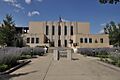
The Stark County Courthouse in Dickinson.
See also
 In Spanish: Condado de Stark (Dakota del Norte) para niños
