
Belfield, North Dakota facts for kids
Quick facts for kids
Belfield, North Dakota
|
|
|---|---|

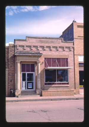
Downtown Belfield
|
|
| Motto(s):
"Gateway To The West"
"Where Friends Meet On The Custer Trail" |
|

Downtown Belfield
|
|
| Country | United States |
| State | North Dakota |
| County | Stark |
| Founded | 1883 |
| Area | |
| • Total | 1.689 sq mi (4.374 km2) |
| • Land | 1.676 sq mi (4.341 km2) |
| • Water | 0.013 sq mi (0.033 km2) |
| Elevation | 2,579 ft (786 m) |
| Population
(2020)
|
|
| • Total | 996 |
| • Estimate
(2023)
|
969 |
| • Density | 594.27/sq mi (229.46/km2) |
| Time zone | UTC–7 (Mountain (MST)) |
| • Summer (DST) | UTC–6 (MDT) |
| ZIP Code |
58622
|
| Area code(s) | 701 |
| FIPS code | 38-05820 |
| GNIS feature ID | 1035926 |
Belfield is a small city in Stark County, North Dakota, United States. It's located just 15 minutes away from the famous Theodore Roosevelt National Park. In 2020, about 996 people lived there.
Belfield was started in 1883. Since then, it has seen many ups and downs, especially because it's in an area rich in oil.
Did you know that in 1883, a strong tornado hit Belfield? It destroyed nine houses, but luckily, no one was hurt. People called it "The Remarkable Tornado of 1883." Exactly one year later, another tornado struck the area. This second storm ruined crops and caused a lot of damage to farms near Belfield.
Contents
Where is Belfield Located?
Belfield covers a total area of about 1.69 square miles (4.37 square kilometers). Most of this area is land, with a very small part being water.
What is the Weather Like?
Belfield has a climate with warm summers and cold winters. It gets both rain and snow throughout the year.
| Climate data for Belfield, North Dakota | |||||||||||||
|---|---|---|---|---|---|---|---|---|---|---|---|---|---|
| Month | Jan | Feb | Mar | Apr | May | Jun | Jul | Aug | Sep | Oct | Nov | Dec | Year |
| Mean daily maximum °F (°C) | 23.5 (−4.7) |
24.4 (−4.2) |
39.7 (4.3) |
51.1 (10.6) |
64 (18) |
75 (24) |
82.9 (28.3) |
81.7 (27.6) |
71.4 (21.9) |
53.8 (12.1) |
39.6 (4.2) |
24.6 (−4.1) |
52.6 (11.5) |
| Mean daily minimum °F (°C) | 9.9 (−12.3) |
11.1 (−11.6) |
25.2 (−3.8) |
34.3 (1.3) |
45.7 (7.6) |
54.9 (12.7) |
61.5 (16.4) |
60.6 (15.9) |
52.7 (11.5) |
38.7 (3.7) |
26.1 (−3.3) |
12.9 (−10.6) |
36.1 (2.3) |
| Average rainfall inches (mm) | 0.43 (11) |
0.47 (12) |
0.75 (19) |
1.22 (31) |
1.93 (49) |
1.85 (47) |
1.93 (49) |
1.46 (37) |
1.5 (38) |
1.22 (31) |
0.55 (14) |
0.47 (12) |
13.78 (350) |
| Average snowfall inches (cm) | 2.4 (6.1) |
3.03 (7.7) |
2.72 (6.9) |
2.28 (5.8) |
1.02 (2.6) |
0 (0) |
0 (0) |
0 (0) |
0 (0) |
2.48 (6.3) |
3.15 (8.0) |
2.64 (6.7) |
19.72 (50.1) |
| Average rainy days (≥ 0.1) | 2.3 | 2.3 | 6.1 | 10.4 | 12.8 | 12.9 | 11.6 | 11.2 | 8.2 | 6.8 | 2.6 | 3.3 | 90.5 |
| Average snowy days | 9.5 | 11.9 | 7.5 | 5 | 1 | 0 | 0 | 0 | 0 | 3.4 | 7.8 | 10.5 | 56.6 |
| Average relative humidity (%) | 87 | 84 | 77 | 64 | 61 | 62 | 54 | 51 | 52 | 61 | 69 | 84 | 67 |
| Mean daily sunshine hours | 4.4 | 4.4 | 6 | 8.5 | 9.6 | 10.8 | 11.5 | 11.3 | 9.8 | 6.4 | 5.6 | 4.5 | 7.7 |
| Mean daily daylight hours | 9 | 10.4 | 12 | 13.6 | 15.1 | 15.8 | 15.4 | 14.1 | 12.5 | 10.9 | 9.4 | 8.6 | 12.2 |
| Average ultraviolet index | 2 | 2 | 3 | 3 | 4 | 5 | 6 | 6 | 4 | 2 | 2 | 2 | 3 |
| Source: Weather Atlas | |||||||||||||
Who Lives in Belfield?
Here's a quick look at how Belfield's population has changed over the years:
| Historical population | |||
|---|---|---|---|
| Census | Pop. | %± | |
| 1920 | 526 | — | |
| 1930 | 653 | 24.1% | |
| 1940 | 870 | 33.2% | |
| 1950 | 1,051 | 20.8% | |
| 1960 | 1,064 | 1.2% | |
| 1970 | 1,130 | 6.2% | |
| 1980 | 1,274 | 12.7% | |
| 1990 | 887 | −30.4% | |
| 2000 | 866 | −2.4% | |
| 2010 | 800 | −7.6% | |
| 2020 | 996 | 24.5% | |
| 2023 (est.) | 969 | 21.1% | |
| U.S. Decennial Census 2020 Census |
|||
Population in 2010
In 2010, there were 800 people living in Belfield. They lived in 360 households. Most people (97.3%) were White. A small number were Native American, Asian, or from other backgrounds. About 1.9% of the population was Hispanic or Latino.
About 29.4% of households had children under 18 living with them. The average age of people in Belfield was 42.4 years. About 22.2% of the residents were under 18 years old.
What is Belfield's Economy Like?
Belfield is located where two important roads meet: I-94 and U.S. Route 85. This makes it a busy spot for travel and trade. The city's economy is also greatly affected by the oil industry in the area, which has been growing.
See also
 In Spanish: Belfield (Dakota del Norte) para niños
