
Bowman County, North Dakota facts for kids
Quick facts for kids
Bowman County
|
|
|---|---|

Dakota Western Bank in Bowman, North Dakota
|
|

Location within the U.S. state of North Dakota
|
|
 North Dakota's location within the U.S. |
|
| Country | |
| State | |
| Founded | 1883 (created) 1907 (organized) |
| Named for | Edward M. Bowman |
| Seat | Bowman |
| Largest city | Bowman |
| Area | |
| • Total | 1,167 sq mi (3,020 km2) |
| • Land | 1,162 sq mi (3,010 km2) |
| • Water | 5.2 sq mi (13 km2) 0.4% |
| Population
(2020)
|
|
| • Total | 2,993 |
| • Estimate
(2022)
|
2,894 |
| • Density | 2.5647/sq mi (0.9902/km2) |
| Time zone | UTC−7 (Mountain) |
| • Summer (DST) | UTC−6 (MDT) |
| Congressional district | At-large |
Bowman County is a county located in the southwestern part of North Dakota, a state in the United States. In 2020, about 2,993 people lived here. The main town and government center of the county is Bowman.
Contents
History of Bowman County
How Bowman County Was Formed
The area that is now Bowman County was first set aside as a county on March 8, 1883. This happened when the government of the Dakota Territory made the decision. The county was named after Edward M. Bowman, who was a member of the territory's government at the time. However, the county wasn't fully set up or organized yet.
Over the years, the county's borders changed a few times. In 1885, some land was given to nearby Billings and Villard Counties. Later, in 1891 and 1896, there were attempts to get rid of Bowman County completely because very few people lived there. But these attempts didn't work out.
Becoming an Official County
On May 24, 1901, a court decision officially brought Bowman County back. This decision also made the county a little bigger. Since the county still didn't have its own local government, it was temporarily linked to Stark County for legal matters starting in 1903.
In November 1904, the county was dissolved again, and its land was given to Billings County. But on June 10, 1907, the Governor of North Dakota, John Burke, announced that Bowman County was created once more. This time, it was not linked to any other county for legal reasons. So, on July 5, 1907, Bowman County officially set up its own government, and Bowman was confirmed as the county seat.
A Ship Named After the County
During World War II, a U.S. Navy ship called the USS Bowman County (LST-391) was named after this county. It was a special ship designed to land tanks and troops on beaches.
Geography of Bowman County
Where Bowman County Is Located
Bowman County is in the very southwest corner of North Dakota. To the south, it shares a border with South Dakota, and to the west, it borders Montana.
Rivers and Lakes
The Little Missouri River flows north through the western part of the county. The North Fork of the Grand River flows east through the lower part of the county. This river helps fill a lake called Bowman-Haley Lake. Spring Creek also flows through the middle of the county and into Bowman-Haley Lake.
Land and Hills
The land in Bowman County has high, dry hills running from north to south in the western-central area. The rest of the county has lower hills. Some of the land is used for farming. The highest point in the county is about 3,228 feet (984 meters) above sea level. The county covers a total area of about 1,167 square miles (3,023 square kilometers). Most of this is land, with only a small part being water.
Main Roads
 U.S. Highway 12
 U.S. Highway 85
 North Dakota Highway 67
Neighboring Counties
- Slope County - north
- Adams County - east
- Harding County, South Dakota - south
- Fallon County, Montana - west
Major Lakes
- Bowman-Haley Lake
- Gascoyne Lake
Population of Bowman County
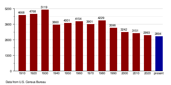
| Historical population | |||
|---|---|---|---|
| Census | Pop. | %± | |
| 1910 | 4,668 | — | |
| 1920 | 4,768 | 2.1% | |
| 1930 | 5,119 | 7.4% | |
| 1940 | 3,860 | −24.6% | |
| 1950 | 4,001 | 3.7% | |
| 1960 | 4,154 | 3.8% | |
| 1970 | 3,901 | −6.1% | |
| 1980 | 4,229 | 8.4% | |
| 1990 | 3,596 | −15.0% | |
| 2000 | 3,242 | −9.8% | |
| 2010 | 3,151 | −2.8% | |
| 2020 | 2,993 | −5.0% | |
| 2022 (est.) | 2,894 | −8.2% | |
| U.S. Decennial Census 1790-1960 1900-1990 1990-2000 2010-2020 |
|||
How Many People Live Here?
According to the 2020 census, there were 2,993 people living in Bowman County.
Population Changes Over Time
The chart below shows how the population of Bowman County has changed over many years, from 1910 to 2022. You can see how the number of people living in the county has gone up and down.
Communities in Bowman County

Cities
Unincorporated Communities
These are smaller places that are not officially organized as cities or towns.
- Griffin
- Haley
Townships
Townships are smaller local government areas within the county.
- Adelaide
- Amor
- Bowman
- Boyesen
- Buena Vista
- Fischbein
- Gascoyne
- Gem
- Goldfield
- Grainbelt
- Grand River
- Haley
- Ladd
- Langberg
- Marion
- Minnehaha
- Nebo
- Rhame
- Scranton
- Star
- Stillwater
- Sunny Slope
- Talbot
- Whiting
Unorganized Territories
These are areas that do not have their own local government like cities or townships.
See also
 In Spanish: Condado de Bowman para niños
