
Rhame, North Dakota facts for kids
Quick facts for kids
Rhame, North Dakota
|
|
|---|---|
 |
|

Location of Rhame, North Dakota
|
|
| Country | United States |
| State | North Dakota |
| County | Bowman |
| Founded | 1908 |
| Incorporated (village) |
1913 |
| Incorporated (city) |
1967 |
| Named for | Mitchell D. Rhame |
| Area | |
| • Total | 1.50 sq mi (3.87 km2) |
| • Land | 1.50 sq mi (3.87 km2) |
| • Water | 0.00 sq mi (0.00 km2) |
| Elevation | 3,209 ft (978 m) |
| Population
(2020)
|
|
| • Total | 158 |
| • Estimate
(2022)
|
155 |
| • Density | 105.69/sq mi (40.80/km2) |
| Time zone | UTC-7 (Mountain (MST)) |
| • Summer (DST) | UTC-6 (MDT) |
| ZIP code |
58651
|
| Area code(s) | 701 |
| FIPS code | 38-66300 |
| GNIS feature ID | 1036237 |
Rhame (pronounced RAYM) is a small city in Bowman County, North Dakota, USA. In 2020, about 158 people lived there. Rhame was started in 1908.
Contents
History of Rhame
Rhame began in 1908. It was first called Petrel, North Dakota. This happened when the Chicago, Milwaukee, St. Paul and Pacific Railroad, also known as the "Milwaukee Road," built a station here.
The town's post office opened on February 8, 1908. But its name changed to Rhame in June 1908. This was because another railroad station in nearby Adams County was already named Petrel. The city and the area around it were named after Mitchell Davison Rhame. He was a district engineer for the railroad.
Rhame officially became a village in 1913. Later, in 1967, it became a city. This change happened because North Dakota changed its laws. All villages and towns in the state automatically became cities.
Rhame had a weekly newspaper for many years. It was published from 1908 to 1953. The paper changed its name a few times. It was called Rhame Review (1908-1918), then Farmers Review (1918-1920), and then back to Rhame Review (1920-1953).
Education in Rhame
Rhame used to have its own high school. Rhame High School closed in 2006. Its students then joined Bowman High School. This new school is now called Bowman County High School and is located in Bowman, North Dakota.
Even though the high school closed, Rhame still has Rhame Elementary School. This school serves younger students.
A book called Prairie Schoolma'am was written in 1956 by Emily E. Sloan. The story in this novel takes place in Rhame.
Geography of Rhame
Rhame covers an area of about 1.51 square miles (3.87 square kilometers). All of this area is land. There are no large bodies of water within the city limits.
Rhame is known for its high elevation. The city is about 3,192 feet (973 meters) above sea level. This makes it the highest town in all of North Dakota.
Population Changes
| Historical population | |||
|---|---|---|---|
| Census | Pop. | %± | |
| 1920 | 302 | — | |
| 1930 | 356 | 17.9% | |
| 1940 | 283 | −20.5% | |
| 1950 | 340 | 20.1% | |
| 1960 | 254 | −25.3% | |
| 1970 | 206 | −18.9% | |
| 1980 | 222 | 7.8% | |
| 1990 | 186 | −16.2% | |
| 2000 | 189 | 1.6% | |
| 2010 | 169 | −10.6% | |
| 2020 | 158 | −6.5% | |
| 2022 (est.) | 155 | −8.3% | |
| U.S. Decennial Census 2020 Census |
|||
Rhame Population in 2010
In 2010, the census counted 169 people living in Rhame. There were 81 households, which are groups of people living together. Out of these, 43 were families.
The city had about 111.9 people per square mile (43.2 people per square kilometer). There were 107 housing units, like houses or apartments.
Most people in Rhame were White, making up 98.2% of the population. About 1.8% of people were from two or more races.
Households and Families
In 2010, 18.5% of households had children under 18 years old. More than half, 50.6%, were married couples living together. About 35.8% of all households were single individuals living alone. Also, 17.2% of households had someone aged 65 or older living by themselves.
The average household had 2.09 people. For families, the average size was 2.81 people.
Age and Gender
The average age of people in Rhame in 2010 was 45.5 years.
- 18.9% of residents were under 18 years old.
- 8.3% were between 18 and 24 years old.
- 21.8% were between 25 and 44 years old.
- 35.5% were between 45 and 64 years old.
- 15.4% were 65 years or older.
When looking at gender, 52.7% of the population was male. The other 47.3% was female.
More About Education
Rhame is part of the Bowman County School District 1. This district runs Rhame School, which teaches students from kindergarten to 6th grade. After elementary school, students from Rhame go to Bowman County High School for their secondary education.
Images for kids
-
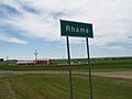
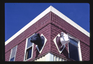
A view of Rhame, North Dakota
-
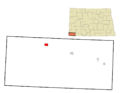
Map showing the location of Rhame in Bowman County
See also
 In Spanish: Rhame (Dakota del Norte) para niños
