Corson County, South Dakota facts for kids
Quick facts for kids
Corson County
|
|
|---|---|

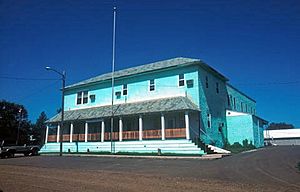
Corson County Courthouse in Maktáža (English: McIntosh), South Dakota in 1993. This building was destroyed by fire on April 10, 2006.
|
|

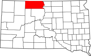
Location within the U.S. state of South Dakota
|
|
 South Dakota's location within the U.S. |
|
| Country | |
| State | |
| Founded | 1909 |
| Named for | Dighton Corson |
| Seat | McIntosh |
| Largest city | McLaughlin |
| Area | |
| • Total | 2,530 sq mi (6,600 km2) |
| • Land | 2,470 sq mi (6,400 km2) |
| • Water | 60 sq mi (200 km2) 2.4% |
| Population
(2020)
|
|
| • Total | 3,902 |
| • Estimate
(2023)
|
3,782 |
| • Density | 1.542/sq mi (0.5955/km2) |
| Time zone | UTC−7 (Mountain) |
| • Summer (DST) | UTC−6 (MDT) |
| Congressional district | At-large |

Corson County is a county located in the state of South Dakota, United States. In 2020, about 3,902 people lived there. The main town and county seat is McIntosh. The county was named after Dighton Corson. He was a lawyer who came to South Dakota in 1876.
The entire county is part of the Standing Rock Indian Reservation. This reservation also stretches into North Dakota. The Lakota people mostly live in the South Dakota part. The Grand River flows through the reservation. It is a branch of the Missouri River.
Contents
Geography
Corson County is located in the northern part of South Dakota. Its northern border touches North Dakota. The Missouri River flows along its eastern side. The county has rolling hills and some areas are used for farming.
The Grand River flows east through the middle of the county. It eventually joins the Missouri River. Corson County covers about 2,530 square miles. Most of this is land, with 60 square miles being water. This makes it the fifth-largest county in South Dakota.
Most counties in eastern South Dakota use Central Time. But Corson County is in the western part. It uses Mountain Time.
Major Roads
These are the main roads that go through Corson County:
 U.S. Highway 12
 South Dakota Highway 20
 South Dakota Highway 63
 South Dakota Highway 65
 South Dakota Highway 1806
Neighboring Areas
Corson County shares borders with these other counties:
- Sioux County, North Dakota – to the north
- Campbell County – to the east
- Walworth County – to the southeast
- Dewey County – to the south
- Ziebach County – to the southwest
- Perkins County – to the west
- Adams County, North Dakota – to the northwest
Nature and Water
Corson County has some natural areas and many bodies of water.
Protected Areas
- Grand River National Grassland (part of it)
- C.C. Lee State Game Production Area
Lakes
- Mallard
- McGee
- McIntosh
- Morristown East
- Morristown West
- Lake Oahe (part of it)
- Pudwell
- Trail City
Rivers and Streams
- Missouri River
- Grand River
- White Shirt Creek
- Hump Creek
- Stink Creek
- Black Horse Butte Creek
- Soldier Creek
- Firesteel Creek
- Oak Creek
- Rock Creek
- Cottonwood Creek
- High Bank Creek
Peaks
- Hump Butte
- Black Horse Butte
- Rattlesnake Butte
- Elk Butte
People of Corson County
| Historical population | |||
|---|---|---|---|
| Census | Pop. | %± | |
| 1910 | 2,929 | — | |
| 1920 | 7,249 | 147.5% | |
| 1930 | 9,535 | 31.5% | |
| 1940 | 6,755 | −29.2% | |
| 1950 | 6,168 | −8.7% | |
| 1960 | 5,798 | −6.0% | |
| 1970 | 4,994 | −13.9% | |
| 1980 | 5,196 | 4.0% | |
| 1990 | 4,195 | −19.3% | |
| 2000 | 4,181 | −0.3% | |
| 2010 | 4,050 | −3.1% | |
| 2020 | 3,902 | −3.7% | |
| 2023 (est.) | 3,782 | −6.6% | |
| U.S. Decennial Census 1790-1960 1900-1990 1990-2000 2010-2020 |
|||
In 2020, the county had 3,902 people living there. There were 1,196 households. The population density was about 1.6 people per square mile.
In 2010, there were 4,050 people. About 67% of the people were American Indian. About 29.7% were white. The average age of people living in the county was 29.7 years old.
Towns and Places
Cities and Towns
- McIntosh (This is the county seat)
- McLaughlin
- Morristown
Other Communities
These are smaller communities in Corson County:
- Bullhead
- Kenel
- Little Eagle
- Wakpala
- Athboy
- Black Horse
- Jeffrey
- Keldron
- Mahto
- Maple Leaf
- Miscol
- Snake Creek
- Thunder Hawk
- Trail City
- Walker
- Watauga
Local Divisions
Counties in South Dakota are divided into smaller areas.
Townships
- Custer
- Delaney
- Lake
- Mission
- Pleasant Ridge
- Prairie View
- Ridgeland
- Rolling Green
- Sherman
- Wakpala
- Watauga
Unorganized Territories
- Central Corson
- Lemmon No. 2
- Northeast Corson
- West Corson
See also
 In Spanish: Condado de Corson para niños
 | Stephanie Wilson |
 | Charles Bolden |
 | Ronald McNair |
 | Frederick D. Gregory |


