McLaughlin, South Dakota facts for kids
Quick facts for kids
McLaughlin
Matȟó Akicita (Lakota)
|
|
|---|---|

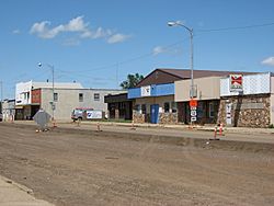
Main Street in McLaughlin
|
|

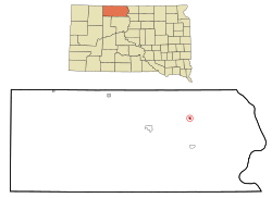
Location in Corson County and the state of South Dakota
|
|
| Country | United States |
| State | South Dakota |
| County | Corson |
| Incorporated | 1909 |
| Area | |
| • Total | 0.40 sq mi (1.05 km2) |
| • Land | 0.40 sq mi (1.05 km2) |
| • Water | 0.00 sq mi (0.00 km2) |
| Elevation | 1,995 ft (608 m) |
| Population
(2020)
|
|
| • Total | 569 |
| • Density | 1,408.42/sq mi (543.39/km2) |
| Time zone | UTC-7 (Mountain (MST)) |
| • Summer (DST) | UTC-6 (MDT) |
| ZIP code |
57642
|
| Area code(s) | 605 |
| FIPS code | 46-40020 |
| GNIS feature ID | 1267468 |
McLaughlin is a city in northeastern Corson County, South Dakota, United States. In the Lakota language, it is called matȟó Akíčita or Makáȟleča, which means "Bear Soldier".
In 2010, the city had a population of 663 people. McLaughlin is the largest city in the southern part of the Standing Rock Indian Reservation.
Contents
History of McLaughlin
The city of McLaughlin is named after James McLaughlin. He was a US Indian Service Agent. He worked at the Standing Rock Indian Agency from 1881 to 1895.
Later, James McLaughlin moved to Washington, D.C.. There, he became an Inspector for the Bureau of Indian Affairs and the Department of the Interior. After he passed away in 1923, his body was brought back to McLaughlin for burial.
Geography and Climate
Where is McLaughlin?
According to the United States Census Bureau, the city covers a total area of 0.40 square miles (1.05 square kilometers). All of this area is land.
Weather in McLaughlin
McLaughlin, South Dakota, experiences a wide range of temperatures throughout the year. Summers are warm, and winters are cold. The hottest month is usually July, and the coldest is January.
The city gets a good amount of rain, especially in late spring and summer. Snowfall is common during the winter months.
| Climate data for McLaughlin, South Dakota (1991−2020 normals, extremes 1919−2020) | |||||||||||||
|---|---|---|---|---|---|---|---|---|---|---|---|---|---|
| Month | Jan | Feb | Mar | Apr | May | Jun | Jul | Aug | Sep | Oct | Nov | Dec | Year |
| Record high °F (°C) | 66 (19) |
71 (22) |
86 (30) |
98 (37) |
100 (38) |
110 (43) |
112 (44) |
108 (42) |
104 (40) |
94 (34) |
77 (25) |
70 (21) |
112 (44) |
| Mean daily maximum °F (°C) | 24.1 (−4.4) |
28.4 (−2.0) |
41.7 (5.4) |
56.2 (13.4) |
68.1 (20.1) |
78.4 (25.8) |
85.4 (29.7) |
83.9 (28.8) |
73.6 (23.1) |
57.4 (14.1) |
41.1 (5.1) |
28.5 (−1.9) |
55.6 (13.1) |
| Daily mean °F (°C) | 13.8 (−10.1) |
17.6 (−8.0) |
30.2 (−1.0) |
42.9 (6.1) |
55.0 (12.8) |
65.6 (18.7) |
71.7 (22.1) |
69.6 (20.9) |
59.5 (15.3) |
44.6 (7.0) |
29.9 (−1.2) |
18.6 (−7.4) |
43.2 (6.2) |
| Mean daily minimum °F (°C) | 3.6 (−15.8) |
6.7 (−14.1) |
18.6 (−7.4) |
29.7 (−1.3) |
41.9 (5.5) |
52.7 (11.5) |
58.0 (14.4) |
55.2 (12.9) |
45.3 (7.4) |
31.8 (−0.1) |
18.8 (−7.3) |
8.6 (−13.0) |
30.9 (−0.6) |
| Record low °F (°C) | −37 (−38) |
−37 (−38) |
−25 (−32) |
−4 (−20) |
15 (−9) |
27 (−3) |
37 (3) |
34 (1) |
16 (−9) |
−6 (−21) |
−25 (−32) |
−35 (−37) |
−37 (−38) |
| Average precipitation inches (mm) | 0.50 (13) |
0.49 (12) |
0.94 (24) |
1.69 (43) |
3.17 (81) |
3.34 (85) |
3.03 (77) |
2.47 (63) |
1.45 (37) |
1.77 (45) |
0.65 (17) |
0.58 (15) |
20.08 (510) |
| Average snowfall inches (cm) | 7.5 (19) |
6.5 (17) |
3.7 (9.4) |
2.1 (5.3) |
0.2 (0.51) |
0.0 (0.0) |
0.0 (0.0) |
0.0 (0.0) |
0.0 (0.0) |
0.7 (1.8) |
4.0 (10) |
10.2 (26) |
34.9 (89) |
| Average precipitation days (≥ 0.01 in) | 3.4 | 4.1 | 4.4 | 6.1 | 8.7 | 9.5 | 7.7 | 5.8 | 4.5 | 4.3 | 2.7 | 3.7 | 64.9 |
| Average snowy days (≥ 0.1 in) | 1.8 | 2.0 | 0.9 | 0.5 | 0.1 | 0.0 | 0.0 | 0.0 | 0.0 | 0.3 | 0.7 | 1.8 | 8.1 |
| Source: NOAA | |||||||||||||
People of McLaughlin
Population Changes Over Time
The population of McLaughlin has changed over many years. Here's a look at how many people have lived there during different census counts:
| Historical population | |||
|---|---|---|---|
| Census | Pop. | %± | |
| 1920 | 555 | — | |
| 1930 | 678 | 22.2% | |
| 1940 | 660 | −2.7% | |
| 1950 | 713 | 8.0% | |
| 1960 | 983 | 37.9% | |
| 1970 | 863 | −12.2% | |
| 1980 | 754 | −12.6% | |
| 1990 | 780 | 3.4% | |
| 2000 | 775 | −0.6% | |
| 2010 | 663 | −14.5% | |
| 2020 | 569 | −14.2% | |
| U.S. Decennial Census | |||
2010 Census Information
In 2010, there were 663 people living in McLaughlin. These people lived in 233 households, and 154 of these were families. The city had about 1657.5 people per square mile.
Most of the people in McLaughlin were Native American (65.3%). About 28.1% were White. A small number of people were Asian or from other backgrounds. About 3.8% of the population was Hispanic or Latino.
Many households (43.8%) had children under 18 living there. The average household had about 2.84 people. The average family had about 3.54 people.
The average age of people in McLaughlin was 31 years old. About 31.8% of residents were under 18. About 11.8% were 65 years old or older. The city had a nearly even number of males (49.2%) and females (50.8%).
See also
 In Spanish: McLaughlin (Dakota del Sur) para niños
 | Precious Adams |
 | Lauren Anderson |
 | Janet Collins |

