Walworth County, South Dakota facts for kids
Quick facts for kids
Walworth County
|
|
|---|---|

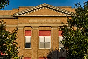
Walworth County Courthouse, Selby
|
|

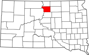
Location within the U.S. state of South Dakota
|
|
 South Dakota's location within the U.S. |
|
| Country | |
| State | |
| Founded | 1873 (created) 1883 (organized) |
| Named for | Walworth County, Wisconsin |
| Seat | Selby |
| Largest city | Mobridge |
| Area | |
| • Total | 745 sq mi (1,930 km2) |
| • Land | 709 sq mi (1,840 km2) |
| • Water | 36 sq mi (90 km2) 4.8% |
| Population
(2020)
|
|
| • Total | 5,315 |
| • Estimate
(2023)
|
5,269 |
| • Density | 7.134/sq mi (2.7545/km2) |
| Time zone | UTC−6 (Central) |
| • Summer (DST) | UTC−5 (CDT) |
| Congressional district | At-large |
Walworth County is a county located in the state of South Dakota in the United States. In 2020, about 5,315 people lived here. The main town, or county seat, is Selby.
Walworth County was first set up in 1873 and officially organized in 1883. It got its name from Walworth County, Wisconsin.
Contents
About Walworth County
The Missouri River flows along the western edge of Walworth County. Swan Creek also runs through the southwest part of the county and joins the Missouri River.
The land here has rolling hills and is mostly dry, which means it doesn't get a lot of rain. Most of the land is used for farming. The county's highest point is about 1,982 feet (604 meters) above sea level.
The county covers a total area of 745 square miles. About 709 square miles of this is land, and 36 square miles (about 4.8%) is water.
Time Zone
South Dakota has two time zones. Most counties in the eastern part of the state use Central Time. Counties in the western part use Mountain Time. Walworth County is the farthest west of the counties that use Central Time.
Roads and Nearby Areas
Major Highways
These are the main roads that go through Walworth County:
 U.S. Highway 12
 U.S. Highway 83
 South Dakota Highway 20
 South Dakota Highway 47
 South Dakota Highway 130
 South Dakota Highway 144
 South Dakota Highway 271
 South Dakota Highway 1804
Neighboring Counties
Walworth County shares borders with these other counties:
- Campbell County to the north
- McPherson County to the northeast
- Edmunds County to the east
- Potter County to the south
- Dewey County to the southwest (this county uses Mountain Time)
- Corson County to the northwest (this county also uses Mountain Time)
Protected Natural Areas
Walworth County has several areas set aside for nature and recreation:
- Blue Blanket Lake State Game Production Area
- Bowdle Beach State Lakeside Use Area
- Indian Creek State Recreation Area
- Lake Hiddenwood State Recreation Area
- LeBeau State Lakeside Use Area
- Oahe Blue Blanket State Game Production Area
- Revheim Bay Recreation Area
- Spring Lake State Game Production Area
- Swan Creek State Game Production Area
- Swan Creek State Recreation Area
- Swan Lake State Game Production Area
- Thomas Bay State Lakeside Use Area
- Walth Bay State Game Production Area
- Walth Bay State Lakeside Use Area
Lakes in the County
These are some of the lakes found in Walworth County:
- Horseshoe Lake
- Lake Hiddenwood
- Lake Oahe (part of this large lake is in the county)
- Molsted Lake
- Spring Lake
- Swan Lake
Population Information
| Historical population | |||
|---|---|---|---|
| Census | Pop. | %± | |
| 1880 | 46 | — | |
| 1890 | 2,153 | 4,580.4% | |
| 1900 | 3,839 | 78.3% | |
| 1910 | 6,488 | 69.0% | |
| 1920 | 8,447 | 30.2% | |
| 1930 | 8,791 | 4.1% | |
| 1940 | 7,274 | −17.3% | |
| 1950 | 7,648 | 5.1% | |
| 1960 | 8,097 | 5.9% | |
| 1970 | 7,842 | −3.1% | |
| 1980 | 7,011 | −10.6% | |
| 1990 | 6,087 | −13.2% | |
| 2000 | 5,974 | −1.9% | |
| 2010 | 5,438 | −9.0% | |
| 2020 | 5,315 | −2.3% | |
| 2023 (est.) | 5,269 | −3.1% | |
| U.S. Decennial Census 1790-1960 1900-1990 1990-2000 2010-2020 |
|||
2020 Census Details
In 2020, the county had 5,315 people. There were 2,271 households and 1,400 families. The population density was about 7.5 people per square mile. There were 2,927 homes in total.
2010 Census Details
In 2010, there were 5,438 people living in Walworth County. There were 2,392 households and 1,490 families. The population density was about 7.7 people per square mile.
Most people in the county were white (82.6%). About 14.3% were American Indian. A small number were Asian, Black, or from other backgrounds. About 0.7% of the people were of Hispanic or Latino origin.
Many people had German (56.9%), Norwegian (12.5%), or Russian (8.9%) family backgrounds.
About 25.9% of households had children under 18 living with them. The average household had 2.21 people, and the average family had 2.79 people. The average age of people in the county was 47.2 years old.
The average income for a household was $39,517. For families, it was $51,250. About 14.5% of the population lived below the poverty line. This included 23.6% of those under 18.
Towns and Communities
Cities
Towns
Unincorporated Community
- Sitka (This is a small community that is not officially organized as a city or town.)
Unorganized Territory
- West Walworth
- East Walworth (These are areas that do not have their own local government.)
Images for kids
See also
 In Spanish: Condado de Walworth (Dakota del Sur) para niños
 | Bayard Rustin |
 | Jeannette Carter |
 | Jeremiah A. Brown |


