Dewey County, South Dakota facts for kids
Quick facts for kids
Dewey County
|
|
|---|---|

|
|

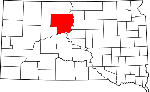
Location within the U.S. state of South Dakota
|
|
 South Dakota's location within the U.S. |
|
| Country | |
| State | |
| Founded | 1883 (created) 1910 (organized) |
| Named for | William P. Dewey |
| Seat | Timber Lake |
| Largest community | North Eagle Butte |
| Area | |
| • Total | 2,445 sq mi (6,330 km2) |
| • Land | 2,302 sq mi (5,960 km2) |
| • Water | 143 sq mi (370 km2) 5.8% |
| Population
(2020)
|
|
| • Total | 5,239 |
| • Estimate
(2023)
|
5,208 |
| • Density | 2.1427/sq mi (0.82732/km2) |
| Time zone | UTC−7 (Mountain) |
| • Summer (DST) | UTC−6 (MDT) |
| Congressional district | At-large |
Dewey County is a county located in the state of South Dakota in the United States. It's like a special area within the state, similar to a district. In 2020, about 5,239 people lived here. The main town, or county seat, where the county government is located, is Timber Lake.
Dewey County was officially created in 1883 and started operating in 1910. It was named after William P. Dewey. He was an important person who helped survey the land in the area from 1873 to 1877.
A big part of Dewey County is inside the Cheyenne River Indian Reservation. A small northern section is also part of the Standing Rock Indian Reservation. This makes Dewey County special, as it is one of only five counties in South Dakota that are mostly within Indian reservations.
Contents
Geography of Dewey County
Dewey County is a place with interesting natural features. The Moreau River flows through the northern part of the county. It eventually joins the Missouri River in the northeast. Smaller streams also carry water towards the Missouri River.
The county's land has rolling hills. These hills gently slope towards the southeast. They then drop down into the wide area of the Missouri River. A large part of the Missouri River forms the southeastern border of the county.
How Big Is Dewey County?
The total size of Dewey County is about 2,445 square miles. Most of this area, about 2,302 square miles, is land. The rest, about 143 square miles, is water. This means about 5.8% of the county is covered by water.
Time Zones
South Dakota has two different time zones. The eastern part of the state uses Central Time. The western part uses Mountain Time. Dewey County is the easternmost county in South Dakota that observes Mountain Time. So, if you travel east from Dewey County, you might need to change your clock!
Main Roads
Several important roads help people travel through Dewey County. These include:
Neighboring Counties
Dewey County shares its borders with several other counties:
- Corson County to the north
- Walworth County to the northeast (this county uses Central Time)
- Potter County to the east (this county also uses Central Time)
- Sully County to the southeast (another Central Time county)
- Stanley County to the south
- Ziebach County to the west
Parks and Lakes
Dewey County has some nice outdoor areas for nature lovers. These include:
- Firesteel Dam State Game Production Area
- Isabel Lake State Game Production Area
- Little Moreau State Game Production Area
- Little Moreau State Recreation Area
There are also a few lakes:
- Lake Isabel
- Lake Oahe (part of this large lake is in Dewey County)
- Little Moreau Lake
People of Dewey County
| Historical population | |||
|---|---|---|---|
| Census | Pop. | %± | |
| 1910 | 1,145 | — | |
| 1920 | 4,802 | 319.4% | |
| 1930 | 6,476 | 34.9% | |
| 1940 | 5,709 | −11.8% | |
| 1950 | 4,916 | −13.9% | |
| 1960 | 5,257 | 6.9% | |
| 1970 | 5,170 | −1.7% | |
| 1980 | 5,366 | 3.8% | |
| 1990 | 5,523 | 2.9% | |
| 2000 | 5,972 | 8.1% | |
| 2010 | 5,301 | −11.2% | |
| 2020 | 5,239 | −1.2% | |
| 2023 (est.) | 5,208 | −1.8% | |
| U.S. Decennial Census 1790-1960 1900-1990 1990-2000 2010-2020 |
|||
Every ten years, the United States counts its population. This is called a census. The census helps us understand how many people live in an area and what their lives are like.
2020 Census Information
In 2020, the census showed that 5,239 people lived in Dewey County. There were 1,705 households, which means groups of people living together. About 1,180 of these were families. The county had about 2.3 people per square mile.
2010 Census Information
The 2010 census counted 5,301 people in Dewey County. Most of the people living here were American Indian (74.9%). About 21.0% were white. A small number of people were from other racial backgrounds. About 1.8% of the population identified as Hispanic or Latino.
The average household in Dewey County had about 3.05 people. The average family had about 3.60 people. The median age of people in the county was 30.0 years old. This means half the people were younger than 30, and half were older.
The median income for a household was $33,255 per year. For families, it was $40,500 per year. These numbers help us understand the economic situation of the people living in Dewey County.
Towns and Communities
Dewey County has several towns and smaller communities where people live.
Cities
- Eagle Butte (part of this city is in Dewey County)
- Timber Lake (This is the county seat, where the main county offices are.)
Town
Census-Designated Places
These are areas that are like towns but are not officially incorporated as cities or towns.
- Green Grass
- La Plant
- Lantry
- North Eagle Butte
- Swift Bird
- Whitehorse
Unincorporated Communities
These are smaller settlements that don't have their own local government.
Unorganized Territories
The county also has two areas that are not part of any city, town, or census-designated place. They are called North Dewey and South Dewey.
See also
 In Spanish: Condado de Dewey (Dakota del Sur) para niños
 | Stephanie Wilson |
 | Charles Bolden |
 | Ronald McNair |
 | Frederick D. Gregory |

