Cheyenne River Indian Reservation facts for kids
Quick facts for kids
Cheyenne River Indian Reservation
|
|
|---|---|
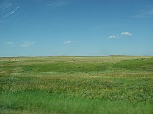
Farmland on the reservation
|
|
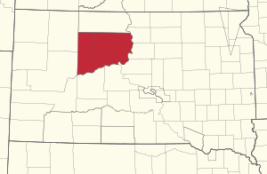
Location in South Dakota
|
|
| Tribe | Cheyenne River Sioux Tribe |
| Country | United States |
| State | South Dakota |
| Counties | Dewey Haakon Meade Stanley Ziebach |
| Established | 1889 |
| Area | |
| • Total | 11,051.447 km2 (4,266.987 sq mi) |
| Population
(2010)
|
|
| • Total | 8,090 |
| Time zone | UTC-7 (MST) |
| • Summer (DST) | UTC-6 (MDT) |
| GDP | $154.8 Million (2018) |
| Website | sioux.org |
The Cheyenne River Indian Reservation is a special area of land in South Dakota, United States. It was created in 1889 for the Lakota people. This happened after a series of wars in the 1870s led to the United States government dividing up the larger Great Sioux Reservation.
Today, the reservation covers most of Dewey and Ziebach counties. It also includes smaller pieces of land in Stanley, Haakon, and Meade counties. The Cheyenne River Indian Reservation is the fourth-largest Indian reservation in the United States by land area. Its biggest community is North Eagle Butte, and the largest city is Eagle Butte.
Contents
Understanding the Land of the Reservation
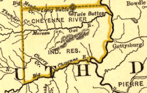
The Cheyenne River Reservation was originally very large, covering over 5,000 square miles. Over time, its size changed. Today, it is about 4,267 square miles (11,051 square kilometers).
How the Reservation Boundaries Changed
The original northern border of the reservation was the Grand River. However, in the early 1900s, some land south of the Grand River became part of the Standing Rock Indian Reservation.
In 1909, some of the reservation land was opened up for people who were not Native American to settle. This was due to new Land Acts. Even with these changes, a large southern part of the Cheyenne River Reservation still remains. It covers about 1,514,652 acres.
Communities on the Land
A small group of White River Utes moved to the reservation in 1906 and 1907. They were given about 92,160 acres of land. Their communities are called Iron Lightning and Thunder Butte. The Missouri River has a tributary called Four Bear Creek, which is also located within the reservation.
A Look at the Reservation's History
The story of the Cheyenne River Indian Reservation begins with the Treaty of Fort Laramie in 1868. This treaty created the huge Great Sioux Reservation. This large area covered parts of six states, including both North and South Dakota.
Breaking Up the Great Sioux Reservation
Later treaties in the 1870s and 1880s divided this big reservation into several smaller ones. The Cheyenne River Indian Reservation was officially created in 1889.
The Story of Chief Sitting Bull
Chief Sitting Bull lived north of the Cheyenne River Reservation, on the Grand River. This area is now part of the Standing Rock Reservation. In 1890, the United States government was worried that Chief Sitting Bull might lead his people away from the reservation.
On December 16, 1890, a group of Indian policemen tried to arrest Chief Sitting Bull. A fight broke out, and Chief Sitting Bull was killed. His son also died in the conflict.
The Wounded Knee Massacre
After this, Chief Sitting Bull's half-brother, Spotted Elk, led about 350 people south. They left the Standing Rock Reservation and went onto the Cheyenne River Reservation. They were later captured on December 28, 1890, on the Pine Ridge Reservation.
The next day, over 500 US Army soldiers attacked them. This terrible event is known as the Wounded Knee Massacre. Many Native Americans were killed, including women and children. This event stopped the group from leaving the reservation. Survivors either stayed on the Pine Ridge Reservation or returned to the Cheyenne River Reservation.
Later Changes to the Reservation
Over the years, the northern border of the Cheyenne River Reservation changed. It is no longer the Grand River. In 1908, the government allowed some land on the reservation to be sold. In 1909, President William Howard Taft officially opened parts of the Cheyenne River Reservation for white settlement. However, most communities along the Grand River today are mainly Native American.
In 1948, the US government built dams on the Missouri River. These dams were for electricity and flood control. But this project caused 8% of the reservation's land to be flooded.
More recently, on August 15, 2018, the tribe launched its own radio station, KIPI. This station helps with education and creates jobs for people on the reservation.
Life on the Reservation Today
The Cheyenne River Indian Reservation is home to the federally recognized Cheyenne River Sioux Tribe. This tribe is also known as the Cheyenne River Lakota Nation. Its members come from four of the traditional seven bands of the Lakota people. These bands are the Minnecoujou, Two Kettle (Oohenunpa), Sans Arc (Itazipco), and Blackfoot (Sihásapa).
Location and Communities
The reservation borders the Standing Rock Indian Reservation to the north. To the west are Meade and Perkins Counties. The Cheyenne River forms the southern border, and the Missouri River (in Lake Oahe) is on the east.
Many parts of the land within the reservation boundaries are privately owned. The main offices for the Cheyenne River Sioux Tribe are in Eagle Butte, South Dakota. You can reach the reservation by taking US-212.
Population and Challenges
In 2010, the population of the reservation was 8,090 people. Many of the 13 small communities on the reservation do not have modern water systems. This makes it hard for people to live in healthy conditions. In recent years, new water systems have been built. These systems get water from the Missouri Main Stem reservoirs, like Lake Oahe.
There are not many jobs available on the reservation or in nearby towns. This means many tribal members do not have jobs. Two-thirds of the people live on much less than the average income in America. These tough living conditions can make young people feel sad or without hope. In 2009, a new medical center was being built in Eagle Butte to replace an older one.
Dealing with Natural Disasters
On January 22, 2010, a big blizzard and ice storm hit the reservation. It knocked down about 3,000 power lines. Thousands of residents were left without power, heat, or water. It took a while for help to arrive.
Even though the state declared an emergency, the situation did not get much attention at first. Power was mostly back on by February 12, 2010, but conditions were still very difficult.
On February 14, 2010, a TV commentator named Keith Olbermann talked about the situation on his show. Within two days, over $250,000 was raised to help the reservation. By February 24, 2010, more than $400,000 had been donated. No one died because of the storm. Some older residents who needed special medical treatment were moved to nearby towns. After the power was restored, tribal leaders focused on getting help to fix the damaged water systems.
Communities on the Reservation
Some communities like Iron Lightning, Thunder Butte, Bullhead, Little Eagle, and Wakpala have been part of the reservation since 1889. Most communities on the Cheyenne River Reservation have a majority Native American population. Many of these communities have very low average incomes. However, Eagle Butte and North Eagle Butte are more economically diverse. The main business area of Eagle Butte is similar to other towns of its size.
- Blackfoot
- Bridger
- Dupree
- Cherry Creek
- Green Grass
- Iron Lightning
- Isabel
- La Plant
- North Bridger
- North Eagle Butte
- Red Scaffold
- Swiftbird
- Thunder Butte
- Timber Lake
- Whitehorse
- Bear Creek, South Dakota
Education on the Reservation
The Cheyenne-Eagle Butte School is located on the reservation. It is run together by the Bureau of Indian Education (BIE) and the Eagle Butte School District 20-1.
Notable People from the Tribe
- Marcella LeBeau – a former tribal council member, nurse, and military veteran.
- Madonna Swan – a Lakota author from the Cheyenne River Indian Reservation.
- Touch the Clouds – a chief of the Minneconjou Teton Lakota.
- Heather Dawn Thompson – an attorney and Director of the Office of Tribal Relations for the USDA.
- Harold Frazier – the tribal chairman since 2014.
- Jana Schmieding – an actor and comedian.
 | Audre Lorde |
 | John Berry Meachum |
 | Ferdinand Lee Barnett |


