Thunder Butte facts for kids
Quick facts for kids Thunder Butte |
|
|---|---|
 |
|
| Highest point | |
| Geography | |
| Geology | |
| Orogeny | Differential erosion |
| Age of rock | Paleocene (66 - 57 mya) |
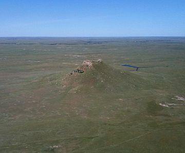
Thunder Butte (in the Lakota language: Wakíŋyaŋ Pahá) is a famous butte in Ziebach County, South Dakota, United States. A butte is a tall, flat-topped hill with steep sides. Thunder Butte is easy to see from far away. It helps people find their way across the wide plains around it.
This special butte also gives its name to a small town nearby. A small creek that flows into the Moreau River is also named after Thunder Butte.
Contents
What is Thunder Butte?
Thunder Butte was shaped by something called differential erosion. This means that softer rocks around it wore away over time. But the harder rock at the top stayed strong. This left the tall, flat-topped shape we see today.
The top of Thunder Butte is 2,733 feet (833 meters) above sea level. It stands about 300 to 500 feet (90 to 150 meters) taller than the grasslands around it. Thunder Butte is the highest point in all of Ziebach County.
Where is Thunder Butte Located?
Thunder Butte sits on a drainage divide. This is like a high ridge that separates river systems. To the north, water flows to the Grand River. To the south, water flows to the Moreau River. Both of these rivers eventually flow east into the big Missouri River.
The butte is about 75 miles (120 km) west of the Missouri River. It is also about 105 miles (170 km) northeast of the Black Hills. These distances are "as the crow flies," meaning in a straight line.
Thunder Butte and Native Americans
For the Lakota people, Thunder Butte is called "Wakinyan Paha." This butte is very important to them. It has a lot of history, religious meaning, and cultural value. In old Lakota stories, it was believed that thunder came from this butte.
The Lakota Sioux tribe has lived in this area since about 1776. They came after other tribes, like the Cheyenne, had lived there. Many Lakota Sioux people still live near Thunder Butte today. In Ziebach County, where the butte is, about 72% of the people are Native American.
Thunder Butte can be clearly seen from two nearby reservations. It is inside the Cheyenne River Indian Reservation. This reservation is home to Lakota people from four different groups. The butte is also close to the southern edge of the Standing Rock Indian Reservation. This reservation has both Lakota and Dakota people.
How Thunder Butte Was Formed
The top of Thunder Butte is made of a strong type of rock. This rock is called the Ludlow Formation. It formed during the Paleocene time, many millions of years ago. This hard rock resists erosion.
The land around the butte is made of softer rock. This softer rock is called the Hell Creek Formation. It wears away much more easily. Because the top layer of Ludlow Formation rock is so tough, it protected the land underneath it. This is why Thunder Butte stands tall while the land around it is lower. Other buttes in western South Dakota were also formed this way.
Places Named After Thunder Butte
A creek called Thunder Butte Creek starts west of the butte. It flows past the southwest side of the butte. Then it goes southeast to join the Moreau River.
There is also a small community named Thunder Butte. It is located near where the creek joins the river.
 | Precious Adams |
 | Lauren Anderson |
 | Janet Collins |


