Moreau River (South Dakota) facts for kids
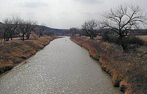
The Moreau River is a river in South Dakota, United States. It is about 200 miles (320 km) long. This river is a branch, or tributary, of the much larger Missouri River. The Moreau River was named after an early trader who explored the area.

Contents
Where the Moreau River Starts and Flows
The Moreau River begins in two main parts, called forks, in the northwestern part of South Dakota. These forks are found in the Badlands area of Butte and Harding Counties.
North and South Forks
The North Fork starts about 10 miles (16 km) northeast of a place called Crow Buttes. The South Fork begins about 20 miles (32 km) west of where the North Fork starts. Both forks flow towards the southeast. They join together near Zeona in southern Perkins County.
Journey to the Missouri River
After the two forks meet, the river flows east. It passes by towns like Usta. The river also flows across the Cheyenne River Indian Reservation. It goes past places such as Iron Lightning, Thunder Butte, Green Grass, and Whitehorse. Finally, the Moreau River joins the Missouri River in Lake Oahe. The last 25 miles (40 km) of the Moreau River actually form a long arm of this large lake.
Facts About the Moreau River
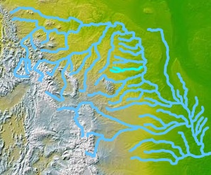
The Moreau River flows in a similar direction to the Grand River. The Grand River is about 40 miles (64 km) to the north. Both rivers run from west to east before joining the Missouri River.
River's Old Name and Size
The Moreau River was once known by a different name: the Owl River. The area of land that drains water into the Moreau River is called its drainage basin. This basin covers about 5,400 square miles (14,000 km²). It collects water from the Pierre Hills and Northern Plateaus.
Other Water Sources and Flow
Besides its North and South Forks, the Moreau River also gets water from Sand Creek. It has several other smaller rivers and streams that flow into it. These are called tributaries. Some of the tributaries include the Little Moreau, Deep, Red Earth, Antelope, and Thunder Butte Rivers. Near a town called Promise, the river's water flows at an average speed of 296 cubic feet per second (8.4 cubic meters per second).
 | Jessica Watkins |
 | Robert Henry Lawrence Jr. |
 | Mae Jemison |
 | Sian Proctor |
 | Guion Bluford |


