Haakon County, South Dakota facts for kids
Quick facts for kids
Haakon County
|
|
|---|---|

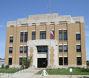
Haakon County Courthouse in Philip
|
|

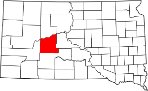
Location within the U.S. state of South Dakota
|
|
 South Dakota's location within the U.S. |
|
| Country | |
| State | |
| Founded | 1914 (created) 1915 (organized) |
| Named for | Haakon VII of Norway |
| Seat | Philip |
| Largest city | Philip |
| Area | |
| • Total | 1,827 sq mi (4,730 km2) |
| • Land | 1,811 sq mi (4,690 km2) |
| • Water | 16 sq mi (40 km2) 0.9% |
| Population
(2020)
|
|
| • Total | 1,872 |
| • Estimate
(2023)
|
1,851 |
| • Density | 1.0246/sq mi (0.39561/km2) |
| Time zone | UTC−7 (Mountain) |
| • Summer (DST) | UTC−6 (MDT) |
| Congressional district | At-large |
Haakon County is a county in the state of South Dakota, United States. As of the 2020 census, about 1,872 people lived here. The main town and county seat is Philip.
Contents
Discovering Haakon County's Past
Haakon County was officially created in 1914 and started operating in 1915. It was formed from parts of older counties called Nowlin and Sterling.
Why is Haakon County Called That?
The county is named after Haakon VII, who became the King of Norway in 1905. The name was chosen to encourage people from Norway to move to the area. This makes Haakon County special because it is the only county in South Dakota named after someone who wasn't American. Most counties in South Dakota are named after local officials, lawmakers, natural features like rivers or lakes, or even Native American words.
Exploring Haakon County's Geography
Haakon County has rolling hills that are somewhat dry. These hills are cut by small valleys and streams. Some of the land is used for farming.
Rivers and Land Features
The Cheyenne River flows along the northern edge of the county. It is a branch of the Missouri River. The Bad River also flows through the southern part of the county. Both rivers eventually join the Missouri River. The land generally slopes down towards the northeast. The highest point in the county is about 2,802 feet (854 meters) above sea level.
Size and Time Zone
Haakon County covers a total area of about 1,827 square miles (4,732 square kilometers). Most of this, about 1,811 square miles (4,690 square kilometers), is land. Only a small part, about 16 square miles (41 square kilometers), is water.
South Dakota has two different time zones. The eastern part of the state uses Central Time, while the western part uses Mountain Time. Haakon County is the most eastern county in South Dakota that observes Mountain Time.
Major Roads in Haakon County
Neighboring Counties
- Ziebach County - north
- Stanley County - east
- Jones County - southeast (uses Central Time)
- Jackson County - south
- Pennington County - west
Protected Natural Areas
- Billsburg State Game Production Area
- Cheyenne State Game Production Area (part)
Lakes in the County
- Waggoner Lake
People of Haakon County
| Historical population | |||
|---|---|---|---|
| Census | Pop. | %± | |
| 1920 | 4,596 | — | |
| 1930 | 4,679 | 1.8% | |
| 1940 | 3,515 | −24.9% | |
| 1950 | 3,167 | −9.9% | |
| 1960 | 3,303 | 4.3% | |
| 1970 | 2,802 | −15.2% | |
| 1980 | 2,794 | −0.3% | |
| 1990 | 2,624 | −6.1% | |
| 2000 | 2,196 | −16.3% | |
| 2010 | 1,937 | −11.8% | |
| 2020 | 1,872 | −3.4% | |
| 2023 (est.) | 1,851 | −4.4% | |
| U.S. Decennial Census 1790-1960 1900-1990 1990-2000 2010-2020 |
|||
Population in 2020
In 2020, there were 1,872 people living in Haakon County. There were 773 households and 510 families. This means there was about 1 person per square mile. There were also 931 housing units.
Population in 2010
In 2010, the county had 1,937 people. There were 850 households and 540 families. The average household had 2.24 people, and the average family had 2.86 people. The average age of people in the county was 48.8 years old.
The median income for a household was about $46,281. For a family, it was about $60,000. About 12.5% of the population lived below the poverty line. This included 14.9% of those under 18 and 13.7% of those aged 65 or older.
Communities in Haakon County
Towns
Smaller Communities (Unincorporated)
These are smaller places that are not officially organized as towns.
- Billsburg
- Kirley
- Milesville
- Nowlin
- Ottumwa
- West Fork
Unorganized Territories
These are areas that do not have their own local government.
- East Haakon
- West Haakon
See also
 In Spanish: Condado de Haakon para niños
 | Bayard Rustin |
 | Jeannette Carter |
 | Jeremiah A. Brown |

