Edmunds County, South Dakota facts for kids
Quick facts for kids
Edmunds County
|
|
|---|---|

|
|

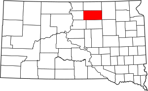
Location within the U.S. state of South Dakota
|
|
 South Dakota's location within the U.S. |
|
| Country | |
| State | |
| Founded | 1873 (founded) 1883 (organized) |
| Named for | Newton Edmunds |
| Seat | Ipswich |
| Largest city | Ipswich |
| Area | |
| • Total | 1,151 sq mi (2,980 km2) |
| • Land | 1,126 sq mi (2,920 km2) |
| • Water | 25 sq mi (60 km2) 2.2% |
| Population
(2020)
|
|
| • Total | 3,986 |
| • Estimate
(2023)
|
4,057 |
| • Density | 3.4631/sq mi (1.3371/km2) |
| Time zone | UTC−6 (Central) |
| • Summer (DST) | UTC−5 (CDT) |
| Congressional district | At-large |
Edmunds County is a county in the U.S. state of South Dakota. It's like a special region within the state. In 2020, about 3,986 people lived here. The main town, or "county seat," is Ipswich.
The county was created in 1873 and officially started working in 1883. It is named after Newton Edmunds, who was an early governor of the Dakota Territory. Edmunds County is also part of the Aberdeen, SD Micropolitan Statistical Area.
Contents
Geography of Edmunds County
Edmunds County has rolling hills, and most of the land is used for farming. The highest point in the county is about 1,978 feet (603 meters) above sea level. The county covers a total area of about 1,151 square miles (2,981 square kilometers). Most of this is land, with about 25 square miles (65 square kilometers) being water.
Main Roads in the County
Here are some of the important highways that go through Edmunds County:
Neighboring Counties
Edmunds County shares its borders with these other counties:
- McPherson County (north)
- Brown County (east)
- Faulk County (south)
- Potter County (southwest)
- Walworth County (west)
Natural Areas and Lakes
Edmunds County has several protected natural areas where wildlife can thrive. There are also a few lakes:
- Bowdle-Hosmer State Game Production Area
- Heilman State Game Production Area
- Hosmer State Game Production Area
- Light State Game Production Area
- Losee State Game Production Area
- Mina Lake State Recreation Area
- Mina State Game Production Area
- North Scatterwood State Game Production Area
- Rosette State Game Production Area
- Schaber State Game Production Area
- Shaner State Game Production Area
- Steigelmier State Game Production Area
Lakes in Edmunds County
- Alkali Lake
- Bowdle-Hosmer Lake
- Grass Lake
- Lake Parmley
- North Scatterwood Lake (partially in the county)
People of Edmunds County
The population of Edmunds County has changed over the years. Here's how it has grown and shrunk:
| Historical population | |||
|---|---|---|---|
| Census | Pop. | %± | |
| 1890 | 4,399 | — | |
| 1900 | 4,916 | 11.8% | |
| 1910 | 7,654 | 55.7% | |
| 1920 | 8,336 | 8.9% | |
| 1930 | 8,712 | 4.5% | |
| 1940 | 7,814 | −10.3% | |
| 1950 | 7,275 | −6.9% | |
| 1960 | 6,079 | −16.4% | |
| 1970 | 5,548 | −8.7% | |
| 1980 | 5,159 | −7.0% | |
| 1990 | 4,356 | −15.6% | |
| 2000 | 4,367 | 0.3% | |
| 2010 | 4,071 | −6.8% | |
| 2020 | 3,986 | −2.1% | |
| 2023 (est.) | 4,057 | −0.3% | |
| U.S. Decennial Census 1790-1960 1900-1990 1990-2000 2010-2020 |
|||
Population in 2020
In 2020, the county had 3,986 people living in 1,546 homes. There were also 1,052 families. On average, there were about 3.5 people per square mile.
Population in 2010
In 2010, there were 4,071 people in Edmunds County. Most people (97.8%) were white. A small number were American Indian, Black, or Asian. About 1.4% of the people were of Hispanic or Latino background.
Many people in the county have German roots (70.8%). Other common backgrounds include Norwegian, Russian, and English. The average age of people living here was about 45.7 years old.
Important Events
Edmunds County was the site of a notable event in 1999. A small jet carrying PGA golfer Payne Stewart and five other people crashed here. The accident happened near the community of Mina.
Towns and Communities
Edmunds County has several towns and smaller communities where people live.
Cities in Edmunds County
Other Communities
These are smaller places that are officially recognized:
- Deerfield Colony
- Mina
- Pembrook Colony
- Plainview Colony
Small Unincorporated Communities
These are even smaller places that don't have their own local government:
See also
 In Spanish: Condado de Edmunds para niños
 | Laphonza Butler |
 | Daisy Bates |
 | Elizabeth Piper Ensley |

