McPherson County, South Dakota facts for kids
Quick facts for kids
McPherson County
|
|
|---|---|

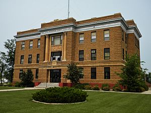
McPherson County Courthouse
|
|

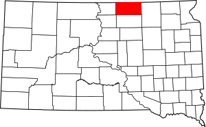
Location within the U.S. state of South Dakota
|
|
 South Dakota's location within the U.S. |
|
| Country | |
| State | |
| Founded | 1873 (created) 1884 (organized) |
| Named for | James B. McPherson |
| Seat | Leola |
| Largest city | Eureka |
| Area | |
| • Total | 1,152 sq mi (2,980 km2) |
| • Land | 1,137 sq mi (2,940 km2) |
| • Water | 15 sq mi (40 km2) 1.3% |
| Population
(2020)
|
|
| • Total | 2,411 |
| • Estimate
(2023)
|
2,334 |
| • Density | 2.0929/sq mi (0.8081/km2) |
| Time zone | UTC−6 (Central) |
| • Summer (DST) | UTC−5 (CDT) |
| Congressional district | At-large |
McPherson County is a county in the state of South Dakota, USA. As of the 2020 census, about 2,411 people lived here. The main town and county seat is Leola.
Contents
History of McPherson County
This county was officially created in 1873. It began to organize its government in 1884. The county is named after James B. McPherson, who was an important general during the American Civil War.
Geography of McPherson County
McPherson County is located in the northern part of South Dakota. Its northern border touches the state of North Dakota. The land in the county has gentle rolling hills. Most of the land is used for farming. You can also see many small lakes and ponds here. The land generally slopes towards the south and east.
The county covers a total area of 1,152 square miles (2,984 square kilometers). Out of this, 1,137 square miles (2,945 square kilometers) is land, and 15 square miles (39 square kilometers) is water. This means about 1.3% of the county is covered by water.
Samuel H. Ordway Jr., Memorial Prairie
On the south side of South Dakota Highway 10, about 10 miles (16 km) west of Leola, is the Samuel H. Ordway Jr., Memorial Prairie. This is a large grassland that covers 7,800 acres. It is owned by The Nature Conservancy, an organization that protects nature. This prairie is home to a herd of bison.
Main Roads in McPherson County
Neighboring Counties
McPherson County shares borders with these other counties:
- McIntosh County, North Dakota - to the north
- Dickey County, North Dakota - to the northeast
- Brown County - to the east
- Edmunds County - to the south
- Walworth County - to the southwest
- Campbell County - to the west
Protected Natural Areas
There are several protected areas in McPherson County, often called State Game Production Areas. These places help protect wildlife and their habitats.
- Elm Lake State Game Production Area
- Moscow State Game Production Area
- Morlock State Game Production Area
- North Jackson State Game Production Area
- Odessa State Game Production Area
- Pfeiffle-Neuharth State Game Production Area
- Rath State Game Production Area
- Rosenthal State Game Production Area
- Schock State Game Production Area
- Schumacher State Game Production Area
- Simpson State Game Production Area
- School State Game Production Area
- South Jackson State Game Production Area
- Stout State Game Production Area
- Wageman State Game Production Area
- Wolff State Game Production Area
Lakes in McPherson County
Many small lakes are found throughout the county:
- Crompton Lake
- Elm Lake (partially)
- Eureka Lake
- Feinstein Lake
- Hausauer Lake
- Heufel Lake
- Klooz Lake
- Long Lake
People of McPherson County (Demographics)
| Historical population | |||
|---|---|---|---|
| Census | Pop. | %± | |
| 1890 | 5,940 | — | |
| 1900 | 6,327 | 6.5% | |
| 1910 | 6,791 | 7.3% | |
| 1920 | 7,705 | 13.5% | |
| 1930 | 8,774 | 13.9% | |
| 1940 | 8,353 | −4.8% | |
| 1950 | 7,071 | −15.3% | |
| 1960 | 5,821 | −17.7% | |
| 1970 | 5,022 | −13.7% | |
| 1980 | 4,027 | −19.8% | |
| 1990 | 3,228 | −19.8% | |
| 2000 | 2,904 | −10.0% | |
| 2010 | 2,459 | −15.3% | |
| 2020 | 2,411 | −2.0% | |
| 2023 (est.) | 2,334 | −5.1% | |
| U.S. Decennial Census 1790-1960 1900-1990 1990-2000 2010-2020 |
|||
Population in 2020
According to the 2020 census, there were 2,411 people living in McPherson County. There were 940 households and 580 families. The population density was about 2.1 people per square mile.
Population in 2010
In the 2010 census, there were 2,459 people in the county. Most people (98.2%) were white. Other groups included 0.2% Asian and 0.1% Pacific islander. About 1.0% of the population was of Hispanic or Latino origin.
Many people in McPherson County have German (74.5%) and Russian (17.7%) ancestry. Other ancestries include Norwegian, English, and American.
The average age of people in the county was 50.8 years old.
Towns and Communities
Here are the different types of communities you can find in McPherson County:
Cities
Towns
Census-Designated Places (CDPs)
These are areas that are like towns but are not officially incorporated as cities or towns.
- Grassland Colony
- Long Lake Colony
- Spring Creek Colony
Unincorporated Communities
These are small settlements that do not have their own local government.
- Greenway
- Long Lake Colony
- Madra (partially)
Townships
Townships are smaller local government areas within the county.
- Carl
- Hoffman
- Wachter
- Wacker
- Weber
See also
 In Spanish: Condado de McPherson (Dakota del Sur) para niños
 | Stephanie Wilson |
 | Charles Bolden |
 | Ronald McNair |
 | Frederick D. Gregory |

