Wilton, North Dakota facts for kids
Quick facts for kids
Wilton, North Dakota
|
|
|---|---|

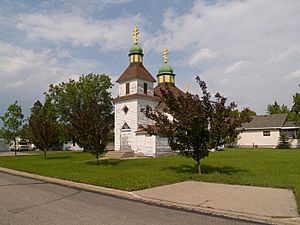
Holy Trinity Ukrainian Greek Orthodox Church in Wilton
|
|
| Motto(s):
"A city rich in its past and future..."
|
|

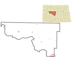
Location of Wilton, North Dakota
|
|
| Country | United States |
| State | North Dakota |
| Counties | McLean, Burleigh |
| Founded | 1899 |
| Area | |
| • Total | 0.57 sq mi (1.47 km2) |
| • Land | 0.56 sq mi (1.44 km2) |
| • Water | 0.01 sq mi (0.03 km2) |
| Elevation | 2,172 ft (662 m) |
| Population
(2020)
|
|
| • Total | 718 |
| • Estimate
(2022)
|
711 |
| • Density | 1,291.37/sq mi (498.47/km2) |
| Time zone | UTC-6 (Central (CST)) |
| • Summer (DST) | UTC-5 (CDT) |
| ZIP code |
58579
|
| Area code(s) | 701 |
| FIPS code | 38-86580 |
| GNIS feature ID | 1036337 |
Wilton is a small city located in North Dakota, United States. It sits across two counties: Burleigh and McLean. Wilton is part of the larger Bismarck area. In 2020, about 718 people lived there. The city was founded in 1899. General W. D. Washburn named Wilton after his hometown of Wilton, Maine.
Contents
History of Wilton
Wilton was officially planned out in 1899. This happened when the railroad tracks were extended to reach that spot. The city got its name from Wilton, Maine. This was the original home of an early settler.
The Wilton Train Station was finished in 1900. The local post office also started operating in Wilton that same year. Many of the first people to build up Wilton were from Ukraine.
Geography and Climate
Where is Wilton Located?
Wilton covers a total area of about 1.47 square kilometers (0.57 square miles). Most of this area is land. Only a small part, about 0.03 square kilometers (0.01 square miles), is water.
Wilton's Weather Patterns
Wilton experiences a humid continental climate. This means the city has big changes in temperature throughout the year. Summers can be warm to very hot, and sometimes humid. Winters are usually very cold.
Population and People
| Historical population | |||
|---|---|---|---|
| Census | Pop. | %± | |
| 1910 | 437 | — | |
| 1920 | 108 | −75.3% | |
| 1930 | 149 | 38.0% | |
| 1940 | 117 | −21.5% | |
| 1950 | 134 | 14.5% | |
| 1960 | 105 | −21.6% | |
| 1970 | 116 | 10.5% | |
| 1980 | 262 | 125.9% | |
| 1990 | 728 | 177.9% | |
| 2000 | 807 | 10.9% | |
| 2010 | 711 | −11.9% | |
| 2020 | 718 | 1.0% | |
| 2022 (est.) | 711 | 0.0% | |
| U.S. Decennial Census 2020 Census |
|||
Who Lives in Wilton?
The census in 2010 counted 711 people living in Wilton. There were 317 households and 188 families. The city had about 1128 people per square mile.
Most of the people in Wilton were White (96.3%). About 2.1% were Native American. A small number were Asian or from other backgrounds. About 1.3% of the population was Hispanic or Latino.
Households and Ages
Out of all the households, about 24% had children under 18 living there. Nearly half (47.6%) were married couples. About 35% of households were made up of single individuals. Around 12% of households had someone aged 65 or older living alone.
The average age in Wilton was 46.7 years. About 19.7% of residents were under 18. People aged 45 to 64 made up the largest group, at 32.9%. The city had slightly more males (53.2%) than females (46.8%).
Education in Wilton
Students in Wilton attend schools that are part of the Wilton Public School District 1.
Images for kids
See also
 In Spanish: Wilton (Dakota del Norte) para niños
 | James B. Knighten |
 | Azellia White |
 | Willa Brown |


