
Ransom County, North Dakota facts for kids
Quick facts for kids
Ransom County
|
|
|---|---|

Ransom County Courthouse
|
|

Location within the U.S. state of North Dakota
|
|
 North Dakota's location within the U.S. |
|
| Country | |
| State | |
| Founded | January 4, 1873 (created) April 4, 1881 (organized) |
| Named for | Fort Ransom |
| Seat | Lisbon |
| Largest city | Lisbon |
| Area | |
| • Total | 864 sq mi (2,240 km2) |
| • Land | 862 sq mi (2,230 km2) |
| • Water | 1.4 sq mi (4 km2) 0.2% |
| Population
(2020)
|
|
| • Total | 5,703 |
| • Estimate
(2022)
|
5,640 |
| • Density | 6.601/sq mi (2.5485/km2) |
| Time zone | UTC−6 (Central) |
| • Summer (DST) | UTC−5 (CDT) |
| Congressional district | At-large |
Ransom County is a county in the U.S. state of North Dakota. It's like a big area with its own local government. In 2020, about 5,703 people lived here. The main town, where the county government is, is called Lisbon.
Contents
History of Ransom County
The area now known as Ransom County was officially created on January 4, 1873. This was done by the government of the Dakota Territory, which was a large region before North Dakota became a state.
Why is it called Ransom County?
The county got its name from a military fort called Fort Ransom. This fort was named after Major General Thomas E.G. Ransom. He was a brave soldier who fought in the American Civil War. The fort was active from 1867 to 1872.
How Ransom County Grew
When the county was first created, it didn't have its own local government yet. Its borders changed a couple of times in 1881. On April 4, 1881, Ransom County officially set up its own government. A few years later, in 1883, its size was made a bit smaller when Sargent County was created. Since then, Ransom County has kept the same shape and size it has today.
Geography of Ransom County
Ransom County is a beautiful area with rolling hills. The Sheyenne River winds its way through the county. In the western part, you can find many lakes and ponds. Most of the land here is used for farming.
The land gently slopes downwards towards the east and south. The highest point in the county is on its northern border, near the northwest corner. It's about 1,421 feet (433 meters) above sea level. The county covers a total area of 864 square miles (2,238 square kilometers). Most of this is land (862 square miles), with a small amount of water (1.4 square miles).
Main Roads in Ransom County
 North Dakota Highway 27
 North Dakota Highway 32
 North Dakota Highway 46
Neighboring Counties
Ransom County shares its borders with several other counties:
- Cass County - to the northeast
- Richland County - to the east
- Sargent County - to the south
- Dickey County - to the southwest
- LaMoure County - to the west
- Barnes County - to the northwest
Special Natural Areas
Ransom County is home to several protected natural areas and parks, including:
- Browns Ranch
- Fort Ransom State Historic Site
- Fort Ransom State Park
- Nature Conservancy's Sheyenne Delta
- North Country Trail
- Pigeon Point Reserve
- Sheyenne National Grassland (part)
- Sheyenne State Forest
Lakes in Ransom County
- Lone Tree Lake
People of Ransom County
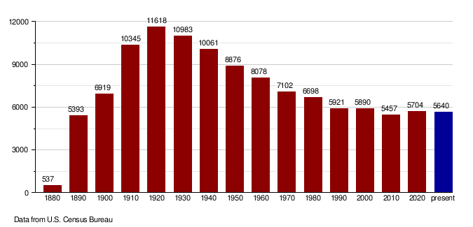
Every ten years, the United States counts its population in a census. This helps us understand how many people live in different areas.
| Historical population | |||
|---|---|---|---|
| Census | Pop. | %± | |
| 1880 | 537 | — | |
| 1890 | 5,393 | 904.3% | |
| 1900 | 6,919 | 28.3% | |
| 1910 | 10,345 | 49.5% | |
| 1920 | 11,618 | 12.3% | |
| 1930 | 10,983 | −5.5% | |
| 1940 | 10,061 | −8.4% | |
| 1950 | 8,876 | −11.8% | |
| 1960 | 8,078 | −9.0% | |
| 1970 | 7,102 | −12.1% | |
| 1980 | 6,698 | −5.7% | |
| 1990 | 5,921 | −11.6% | |
| 2000 | 5,890 | −0.5% | |
| 2010 | 5,457 | −7.4% | |
| 2020 | 5,703 | 4.5% | |
| 2022 (est.) | 5,640 | 3.4% | |
| U.S. Decennial Census 1790-1960 1900-1990 1990-2000 2010-2020 |
|||
Population in 2020
According to the 2020 census, there were 5,704 people living in Ransom County.
Population Changes Over Time
The chart below shows how the population of Ransom County has changed over many years, from 1880 up to recent estimates. You can see how the number of people living here has gone up and down.
Towns and Communities
Ransom County has several towns and smaller communities.
Cities in Ransom County
- Elliott
- Enderlin (partly in Cass County)
- Fort Ransom
- Lisbon (this is the main town, or county seat)
- Sheldon
Other Communities
These are smaller communities that are counted in the census:
Townships
Ransom County is also divided into many smaller areas called townships:
- Aliceton
- Alleghany
- Bale
- Big Bend
- Casey
- Coburn
- Elliott
- Fort Ransom
- Greene
- Hanson
- Island Park
- Isley
- Liberty
- McLeod
- Moore
- Northland
- Owego
- Preston
- Rosemeade
- Sandoun
- Scoville
- Shenford
- Springer
- Sydna
- Tuller
Education in Ransom County
Students in Ransom County attend schools in various school districts. Some of these districts cover parts of other counties too.
School Districts
- Enderlin Area Public School District 24
- Fort Ransom Public School District 6
- Kindred Public School District 2
- LaMoure Public School District 8
- Litchville-Marion Public School District 46
- Lisbon Public School District 19
- Milnor Public School District 2
- North Sargent Public School District 3
- Oakes Public School District 41
- Wyndmere Public School District 42
In 1905, Ransom County had 22 school districts. At that time, there were 2,431 students attending three high schools, five grade schools, and 75 schoolhouses across the county.
Images for kids
-
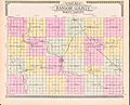
An outline map of Ransom County, North Dakota, from 1910.

See also
 In Spanish: Condado de Ransom para niños
