Arvilla, North Dakota facts for kids
Quick facts for kids
Arvilla, North Dakota
|
|
|---|---|

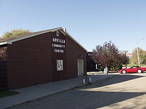
Arvilla Community Center
|
|
| Country | United States |
| State | North Dakota |
| County | Grand Forks |
| Elevation | 1,004 ft (306 m) |
| Time zone | UTC-6 (Central (CST)) |
| • Summer (DST) | UTC-5 (CDT) |
| ZIP codes |
58214
|
| Area code(s) | 701 |
| GNIS feature ID | 1027748 |
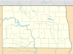
Arvilla (also known as Orange) is a small, unincorporated community. This means it's a place where people live, but it doesn't have its own local government like a city or town. Arvilla is located in central Grand Forks County, North Dakota, in the United States.
You can find Arvilla along U.S. Route 2. It is west of the city of Grand Forks. Grand Forks is the main city, or county seat, of Grand Forks County. Arvilla sits at an elevation of 1,004 feet (306 meters) above sea level.
The community was first named Orange. This name came from Orange County, New York. Later, it was renamed Arvilla. This new name honored Arvilla Estella Hersey. She was the wife of a local farmer. Even though Arvilla is unincorporated, it has its own post office. Its ZIP code is 58214.
What is Arvilla's Climate Like?
Arvilla has a climate with big changes between seasons. Summers are warm to hot, and often humid. Winters are cold, sometimes very cold. This type of weather is called a "humid continental climate." On climate maps, it's shown as "Dfb."
How Do People Travel Through Arvilla?
Amtrak is a passenger train service in the United States. Their train, the Empire Builder, travels through Arvilla. This train connects cities like Seattle and Portland to Chicago.
The Empire Builder uses BNSF train tracks as it passes through Arvilla. However, the train does not stop in Arvilla. The closest train station for passengers is in Grand Forks. This station is about 20 miles (32 km) to the east of Arvilla.
 | William M. Jackson |
 | Juan E. Gilbert |
 | Neil deGrasse Tyson |


