
Walsh County, North Dakota facts for kids
Quick facts for kids
Walsh County
|
|
|---|---|

Walsh County Courthouse
|
|

Location within the U.S. state of North Dakota
|
|
 North Dakota's location within the U.S. |
|
| Country | |
| State | |
| Founded | May 2, 1881 (created) August 30, 1881 (organized) |
| Named for | George H. Walsh |
| Seat | Grafton |
| Largest city | Grafton |
| Area | |
| • Total | 1,294.032 sq mi (3,351.53 km2) |
| • Land | 1,281.607 sq mi (3,319.35 km2) |
| • Water | 12.425 sq mi (32.18 km2) 0.9%% |
| Population
(2020)
|
|
| • Total | 10,563 |
| • Estimate
(2023)
|
10,305 |
| • Density | 8.042/sq mi (3.105/km2) |
| Time zone | UTC−6 (Central) |
| • Summer (DST) | UTC−5 (CDT) |
| Congressional district | At-large |
Walsh County is a county in the state of North Dakota in the United States. A county is like a smaller area within a state, often with its own local government. As of the 2020 census, about 10,563 people lived there. The main town, or county seat, where the county government is located, is Grafton.
Contents
History of Walsh County
Walsh County was created on May 2, 1881, by the government of the Dakota Territory. It was formed from parts of Grand and Pembina counties. The county officially started operating on August 30 of the same year. Grafton was chosen as its county seat.
The county was named after George H. Walsh (1845–1913). He was a newspaper owner and a leader in politics from Grand Forks.
In 1946, Walsh County experienced one of the most serious tornadoes in North Dakota's history. This powerful storm caused 11 deaths in total. Eight people died in Walsh County, one in Manitoba (Canada), and two in Minnesota.

Geography of Walsh County
Walsh County is located on the eastern side of North Dakota. Its eastern border is right next to the state of Minnesota. The Red River flows north along the east side of the county. This river eventually flows into Hudson Bay in Canada.
The south branch of the Park River also flows through the county, heading east to join the Red River. The land in Walsh County generally slopes down towards the north and east. The highest point in the county is in its northwestern corner, which is about 1,647 feet (502 meters) above sea level (ASL).
According to the United States Census Bureau, Walsh County covers a total area of about 1,294 square miles (3,351 square kilometers). Most of this area, about 1,282 square miles (3,320 square kilometers), is land. The remaining 12.4 square miles (32 square kilometers), or 0.9%, is water.
Main Roads in Walsh County
 Interstate 29
 U.S. Highway 81
 North Dakota Highway 17
 North Dakota Highway 18
 North Dakota Highway 32
 North Dakota Highway 35
Neighboring Counties
Walsh County shares borders with several other counties:
- Pembina County – to the north
- Kittson County, Minnesota – to the northeast
- Marshall County, Minnesota – to the east
- Grand Forks County – to the south
- Nelson County – to the southwest
- Ramsey County – to the west
- Cavalier County – to the northwest
Protected Natural Areas
Walsh County has several areas set aside to protect wildlife and nature:
- Ardoch National Wildlife Refuge
- Fairdale Slough National Waterfowl Production Area
- National Waterfowl Production Area
- North Salt Lake State Game Management Area
Lakes in Walsh County
- Fairdale Slough
- Homme Lake
- North Salt Lake
- Salt Lake
- Waterloo Lake
People of Walsh County (Demographics)
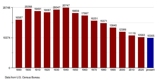
| Historical population | |||
|---|---|---|---|
| Census | Pop. | %± | |
| 1890 | 16,587 | — | |
| 1900 | 20,288 | 22.3% | |
| 1910 | 19,491 | −3.9% | |
| 1920 | 19,087 | −2.1% | |
| 1930 | 20,047 | 5.0% | |
| 1940 | 20,747 | 3.5% | |
| 1950 | 18,859 | −9.1% | |
| 1960 | 17,997 | −4.6% | |
| 1970 | 16,251 | −9.7% | |
| 1980 | 15,371 | −5.4% | |
| 1990 | 13,840 | −10.0% | |
| 2000 | 12,389 | −10.5% | |
| 2010 | 11,119 | −10.3% | |
| 2020 | 10,563 | −5.0% | |
| 2023 (est.) | 10,305 | −7.3% | |
| U.S. Decennial Census 1790-1960 1900-1990 1990-2000 2010-2020 |
|||
In early 2024, the average value of a home in Walsh County was about $123,610.
As of 2023, there were about 4,467 households in Walsh County. On average, each household had about 2.27 people. The average income for a household was $68,082 per year. About 9.7% of the people in the county lived below the poverty line, meaning they had very low incomes.
About 64.3% of the people in Walsh County had jobs. When it comes to education, about 17.9% of the population had a college degree or higher, and 86.9% had at least a high school diploma.
The most common backgrounds people reported were English (91.8%), Spanish (6.1%), and Indo-European (1.6%). The average age of people in the county was 44.6 years old.
Walsh County Population Changes Over Time
2020 Census Information
In 2020, the census counted 10,563 people living in Walsh County. There were 4,493 households and 2,738 families. The population density was about 8.2 people per square mile.
Most of the people (86.01%) were White. Other groups included African American (0.67%), Native American (1.37%), and Asian (0.44%). About 12.46% of the population identified as Hispanic or Latino.
About 23.4% of residents were under 18 years old, and 22.9% were 65 years or older.
2010 Census Information
According to the 2010 census, there were 11,119 people in the county. The population density was about 8.67 people per square mile.
The main backgrounds reported were Norwegian (39.7%), German (21.6%), and Polish (11.0%).
The average household size was 2.27 people, and the average family size was 2.88 people. The average age of people in the county was 45.9 years.
The average income for a household was $44,139, and for a family, it was $58,429. About 9.9% of the total population lived below the poverty line.
Communities in Walsh County
Walsh County has several towns and smaller communities.
Cities
Census-Designated Places
These are areas that are like towns but are not officially incorporated as cities.
Unincorporated Communities
These are small settlements that do not have their own local government.
Townships
Townships are smaller divisions of land within a county, often used for local administration.
See also
 In Spanish: Condado de Walsh para niños
