Buxton, North Dakota facts for kids
Quick facts for kids
Buxton, North Dakota
|
|
|---|---|

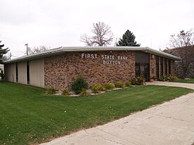
The First State Bank of Buxton
|
|

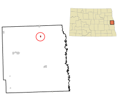
Location of Buxton, North Dakota
|
|
| Country | United States |
| State | North Dakota |
| County | Traill |
| Founded | 1880 |
| Incorporated (village) | 1922 |
| Incorporated (city) | 1967 |
| Area | |
| • Total | 0.334 sq mi (0.865 km2) |
| • Land | 0.334 sq mi (0.865 km2) |
| • Water | 0.000 sq mi (0.000 km2) |
| Elevation | 932 ft (284 m) |
| Population
(2020)
|
|
| • Total | 348 |
| • Estimate
(2023)
|
349 |
| • Density | 1,041.92/sq mi (402.47/km2) |
| Time zone | UTC–6 (Central (CST)) |
| • Summer (DST) | UTC–5 (CDT) |
| ZIP Code |
58218
|
| Area code(s) | 701 |
| FIPS code | 38-11340 |
| GNIS feature ID | 1035949 |
Buxton is a small city located in Traill County, North Dakota, in the United States. In 2020, the city had a population of 348 people. Buxton was first started in 1880.
Contents
History of Buxton
Buxton was founded in 1880. It began as a town along the Great Northern Railroad. The local post office opened in November of that same year.
In 1922, Buxton officially became a village. Later, in 1967, it became a city. This change happened after the North Dakota Legislature passed a law. This law changed how towns and villages were officially named in the state.
The town was named after Thomas J. Buxton. He was a city treasurer in Minneapolis, Minnesota, at the time. Thomas J. Buxton was a close friend and business partner of Budd Reeve, who founded the town.
Buxton's Geography
Buxton is a small city in terms of size. According to the United States Census Bureau, the city covers about 0.334 square miles (0.865 square kilometers). All of this area is land.
People of Buxton
| Historical population | |||
|---|---|---|---|
| Census | Pop. | %± | |
| 1930 | 410 | — | |
| 1940 | 404 | −1.5% | |
| 1950 | 387 | −4.2% | |
| 1960 | 321 | −17.1% | |
| 1970 | 235 | −26.8% | |
| 1980 | 336 | 43.0% | |
| 1990 | 343 | 2.1% | |
| 2000 | 350 | 2.0% | |
| 2010 | 323 | −7.7% | |
| 2020 | 348 | 7.7% | |
| 2023 (est.) | 349 | 8.0% | |
| U.S. Decennial Census 2020 Census |
|||
The population of Buxton has changed over the years. In 1930, there were 410 people. By 1970, the population had dropped to 235. However, it has grown since then. In 2020, 348 people lived in Buxton.
What the 2020 Census Shows
In 2020, there were 348 people living in Buxton. There were 132 households and 97 families. The population density was about 1,735 people per square mile (670 people per square kilometer). This means how many people live in a certain area.
Most people in Buxton were White (94.8%). A small number of residents were African American (0.6%) or Native American (1.1%). About 2.9% of the population identified as being from two or more races. About 1.1% of the population was Hispanic or Latino.
About 22% of the people were under 18 years old. About 7.8% were under 5 years old. And 14.3% of the residents were 65 years old or older.
What the 2010 Census Showed
In 2010, Buxton had 323 people. There were 136 households. The average household had 2.38 people.
Most people (99.4%) were White. A very small number were African American (0.3%) or Native American (0.3%). About 0.9% of the population was Hispanic or Latino.
The average age in the city was 39.4 years. About 23.2% of residents were under 18. About 13.6% were 65 or older. The city had slightly more males (51.4%) than females (48.6%).
Getting Around
The Amtrak train called the Empire Builder passes through Buxton. This train travels between Seattle/Portland and Chicago. However, it does not stop in Buxton. The closest train station is in Grand Forks, North Dakota, which is about 25 miles (40 kilometers) north.
Schools in Buxton
Buxton is part of the Central Valley Public School District 3.
Famous People from Buxton
Some notable people have come from Buxton:
- Asle J. Gronna – He was a U.S. Senator from 1911 to 1921.
- Ragnvald Nestos – He served as Governor of North Dakota from 1921 to 1925.
- Kemper Nomland – An architect.
- Mancur Olson – An economist.
- Arthur G. Sorlie – He was also a Governor of North Dakota from 1925 to 1928.
- Brent Vigen – He is currently the head football coach at Montana State University.
See also
 In Spanish: Buxton (Dakota del Norte) para niños
 | Isaac Myers |
 | D. Hamilton Jackson |
 | A. Philip Randolph |

