Casselton, North Dakota facts for kids
Quick facts for kids
Casselton, North Dakota
|
||
|---|---|---|
|
||

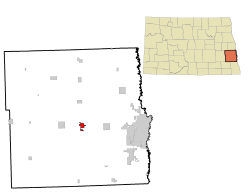
Location of Casselton, North Dakota
|
||
| Country | United States | |
| State | North Dakota | |
| County | Cass | |
| Founded | August 8, 1876 | |
| Incorporated | 1880 | |
| Area | ||
| • Total | 2.192 sq mi (5.677 km2) | |
| • Land | 2.162 sq mi (5.601 km2) | |
| • Water | 0.030 sq mi (0.077 km2) | |
| Elevation | 932 ft (284 m) | |
| Population
(2020)
|
||
| • Total | 2,479 | |
| • Estimate
(2023)
|
2,472 | |
| • Density | 1,143.0/sq mi (441.4/km2) | |
| Time zone | UTC–6 (Central (CST)) | |
| • Summer (DST) | UTC–5 (CDT) | |
| ZIP Code |
58012
|
|
| Area code(s) | 701 | |
| FIPS code | 38-12700 | |
| GNIS feature ID | 1035957 | |
| Sales tax | 7.5% | |
Casselton is a city in Cass County, North Dakota, United States. In 2020, about 2,479 people lived there. This makes it the 20th largest city in North Dakota.
Casselton was started in 1876. It is named after George Washington Cass. He was the president of the Northern Pacific Railway. The railway built a station here in 1876 to help homesteaders settle the land. Casselton is also special because five North Dakota governors grew up here!
Contents
History of Casselton
Casselton began in 1873. The Northern Pacific Railway sent a man named Mike Smith to plant trees. He planted cottonwood and willow trees to act as windbreaks along the railroad tracks. The plan was to use the trees for railroad ties, but it didn't work out.
In 1874, Emil Priewe and his wife joined Mike Smith. Their son, Harry, was born on March 28, 1875. He was the first child born in this new village. More people came to live there. By 1880, the town had 376 people. A school was started in 1876, and the town officially became a village in 1880.
The small settlement had a few different names at first. People called it "the Nursery," "Goose Creek," or "Swan Creek." These names came from a stream that flowed through the area. In 1876, the railroad named its station Casstown, after George Cass. But when the post office opened on August 8, 1876, they chose the name Casselton.
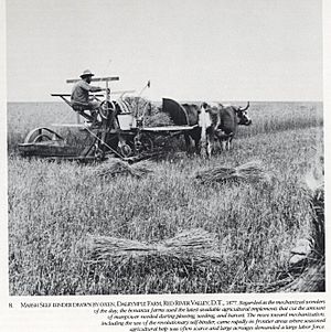
In the 1870s, George Cass and Peter Cheney traded their railroad shares for a lot of land near Casselton. It was about 10,000 acres (40 km2)! They decided to make it one huge farm instead of many small ones. They hired Oliver Dalrymple to manage this big farm. These very large farms, called Bonanza farms, were very successful. They showed that the prairie land was great for farming.
Many things were done to attract new people to Casselton. Immigrants came from Europe, and people from the East came looking for land. Others wanted to become tradesmen or professionals. By 1885, Casselton's population grew to 1,365 people.
The Great Northern Railway also helped Casselton grow. Several train lines started from the city. The railroad dug a large pond, called a reservoir, to get water for its steam engines. In 1906, the railway built a roundhouse and service center. These operated until 1920. After 1920, railroad workers moved to other places. Because of this, Casselton's population dropped by 285 people between 1920 and 1930.
Casselton got a city water and sewer system in the mid-1920s. Water came from deep wells and was stored in a tall standpipe. This standpipe was about 110 feet (34 m) tall and was used until 1956. Today, that spot is a winter skating rink.
By 1957, the Great Northern Railway no longer needed the Casselton reservoir. They gave the 73 acres (300,000 m2) of land, including the reservoir, to the City of Casselton. The city used the reservoir for its water supply until 1978. After that, the city got its water from a different system. Now, the reservoir area is a fun place for recreation. It has softball fields, tennis courts, and picnic areas.
Casselton's streets were also improved over time. In 1927, the downtown roads were covered with gravel. In 1930, during the Great Depression, the federal government helped. They paid local workers to pave State Highway No. 18 through the city. This was part of a project called the Works Progress Administration. After World War II, the streets in the business area were paved with concrete. Now, all streets and avenues in Casselton are paved. A modern storm sewer system was also put in place.
In 1996–1997, a new Central Cass Public School building opened. It cost almost $8 million! It replaced an older three-story building that was built in 1912. The school district covers a large area, about 400 square miles (1,000 km2). More than 800 students attend the school. Because the town kept growing, an addition to the school was finished in 2003–2004.
Casselton is also known for its many American red squirrels. The Central Cass High School even uses the squirrel as its mascot!
2013 Train Derailment
On December 30, 2013, a train carrying soybeans went off its tracks near Casselton. Another train carrying crude oil then hit the wreckage. This caused the crude oil to catch fire and led to big explosions. People heard and felt these explosions miles away! A huge cloud of black smoke filled the sky. As a safety step, people in Casselton and nearby areas were asked to leave their homes.
No one was hurt in the accident. The crew of the oil train left their engines quickly when the train derailed. The National Transportation Safety Board looked into what happened. They found that a broken axle on the first train caused the accident.
This event happened close to where people live. It made many people worry about how dangerous materials are moved by train. The mayor of Casselton, Ed McConnell, said the town "dodged a bullet." He asked the federal government to look into these dangers. He also suggested that pipelines might be a safer way to move these materials.
Casselton's Geography
Casselton covers about 2.192 square miles (5.68 km2) of land. Most of this is land, and a small part is water.
Casselton's Climate
Casselton has a climate with big changes in temperature during the year. Summers are warm to hot and can be humid. Winters are cold, sometimes very cold. This type of weather is called a humid continental climate.
| Climate data for Casselton, North Dakota, 1991–2020 normals, extremes 1984–present | |||||||||||||
|---|---|---|---|---|---|---|---|---|---|---|---|---|---|
| Month | Jan | Feb | Mar | Apr | May | Jun | Jul | Aug | Sep | Oct | Nov | Dec | Year |
| Record high °F (°C) | 56 (13) |
54 (12) |
76 (24) |
92 (33) |
97 (36) |
101 (38) |
107 (42) |
105 (41) |
98 (37) |
93 (34) |
76 (24) |
58 (14) |
107 (42) |
| Mean maximum °F (°C) | 40.4 (4.7) |
42.2 (5.7) |
57.1 (13.9) |
77.5 (25.3) |
88.1 (31.2) |
91.4 (33.0) |
92.1 (33.4) |
91.8 (33.2) |
89.0 (31.7) |
80.5 (26.9) |
59.8 (15.4) |
43.4 (6.3) |
94.8 (34.9) |
| Mean daily maximum °F (°C) | 16.9 (−8.4) |
21.6 (−5.8) |
35.0 (1.7) |
52.8 (11.6) |
67.6 (19.8) |
77.0 (25.0) |
80.8 (27.1) |
79.9 (26.6) |
71.4 (21.9) |
55.6 (13.1) |
37.8 (3.2) |
23.2 (−4.9) |
51.6 (10.9) |
| Daily mean °F (°C) | 7.8 (−13.4) |
11.8 (−11.2) |
25.8 (−3.4) |
41.7 (5.4) |
55.4 (13.0) |
66.0 (18.9) |
69.7 (20.9) |
67.8 (19.9) |
58.9 (14.9) |
44.7 (7.1) |
28.7 (−1.8) |
14.9 (−9.5) |
41.1 (5.1) |
| Mean daily minimum °F (°C) | −1.4 (−18.6) |
2.1 (−16.6) |
16.6 (−8.6) |
30.6 (−0.8) |
43.2 (6.2) |
54.9 (12.7) |
58.6 (14.8) |
55.8 (13.2) |
46.4 (8.0) |
33.8 (1.0) |
19.7 (−6.8) |
6.6 (−14.1) |
30.6 (−0.8) |
| Mean minimum °F (°C) | −23.6 (−30.9) |
−19.2 (−28.4) |
−8.0 (−22.2) |
15.2 (−9.3) |
29.0 (−1.7) |
43.4 (6.3) |
47.6 (8.7) |
44.2 (6.8) |
31.8 (−0.1) |
18.8 (−7.3) |
0.5 (−17.5) |
−15.5 (−26.4) |
−25.5 (−31.9) |
| Record low °F (°C) | −37 (−38) |
−39 (−39) |
−23 (−31) |
1 (−17) |
19 (−7) |
35 (2) |
41 (5) |
36 (2) |
22 (−6) |
8 (−13) |
−33 (−36) |
−34 (−37) |
−39 (−39) |
| Average precipitation inches (mm) | 0.54 (14) |
0.57 (14) |
1.09 (28) |
1.49 (38) |
3.16 (80) |
4.43 (113) |
3.69 (94) |
2.62 (67) |
2.79 (71) |
2.33 (59) |
0.80 (20) |
0.69 (18) |
24.20 (615) |
| Average snowfall inches (cm) | 7.4 (19) |
6.6 (17) |
6.2 (16) |
3.3 (8.4) |
0.0 (0.0) |
0.0 (0.0) |
0.0 (0.0) |
0.0 (0.0) |
0.0 (0.0) |
0.7 (1.8) |
4.4 (11) |
8.1 (21) |
36.7 (94.2) |
| Average precipitation days (≥ 0.01 in) | 4.1 | 4.8 | 5.0 | 6.4 | 10.7 | 11.4 | 9.0 | 8.0 | 7.1 | 7.4 | 4.9 | 5.3 | 84.1 |
| Average snowy days (≥ 0.1 in) | 3.6 | 3.5 | 2.7 | 1.0 | 0.0 | 0.0 | 0.0 | 0.0 | 0.0 | 0.3 | 1.9 | 3.9 | 16.9 |
| Source 1: NOAA | |||||||||||||
| Source 2: National Weather Service | |||||||||||||
Casselton's Population
| Historical population | |||
|---|---|---|---|
| Census | Pop. | %± | |
| 1880 | 360 | — | |
| 1890 | 840 | 133.3% | |
| 1900 | 1,207 | 43.7% | |
| 1910 | 1,553 | 28.7% | |
| 1920 | 1,538 | −1.0% | |
| 1930 | 1,253 | −18.5% | |
| 1940 | 1,358 | 8.4% | |
| 1950 | 1,373 | 1.1% | |
| 1960 | 1,394 | 1.5% | |
| 1970 | 1,485 | 6.5% | |
| 1980 | 1,661 | 11.9% | |
| 1990 | 1,601 | −3.6% | |
| 2000 | 1,855 | 15.9% | |
| 2010 | 2,329 | 25.6% | |
| 2020 | 2,479 | 6.4% | |
| 2023 (est.) | 2,472 | 6.1% | |
| U.S. Decennial Census 2020 Census |
|||
2020 Census Details
| Race | Number | Percent |
|---|---|---|
| White (NH) | 2,290 | 92.4% |
| Black or African American (NH) | 20 | 0.8% |
| Native American (NH) | 22 | 0.9% |
| Asian (NH) | 3 | 0.1% |
| Pacific Islander (NH) | 0 | 0.0% |
| Some Other Race (NH) | 8 | 0.3% |
| Mixed/Multi-Racial (NH) | 92 | 3.7% |
| Hispanic or Latino | 44 | 1.8% |
| Total | 2,479 | 100.0% |
In 2020, there were 2,479 people living in Casselton. There were 941 households and 661 families. About 1,011 homes were in the city. Most people (92.8%) were White. A small number of people were from other racial backgrounds. About 1.8% of the population was Hispanic or Latino.
2010 Census Details
In 2010, Casselton had 2,329 people. There were 874 households, and 633 of them were families. The city had about 1,245 people per square mile. Most people (97.3%) were White. About 2.4% of the population was Hispanic or Latino.
The average age in the city was 34.6 years old. About 31.4% of the people were under 18. About 10.5% were 65 or older. The city had slightly more males (51.4%) than females (48.6%).
Fun Places to Visit
Casselton used to have the world's largest pile of oil cans! It was a free-standing structure. Max Taubert created it in 1933. It was about 45 feet (14 m) tall and made of thousands of oil cans. In 2008, local volunteers saved it from being torn down.
Getting Around Casselton
Major roads that go through or near Casselton include:
- I-94
- US 52
- ND 10
- ND 18
Famous People from Casselton
Some well-known people who have lived in Casselton include:
- Andrew H. Burke, who was the 2nd governor of North Dakota.
- Jack Dalrymple, who was the 32nd governor of North Dakota.
- William Langer, who was governor twice and also a senator.
- George A. Sinner, who was the 29th governor of North Dakota.
- Herman Stern, a businessman and humanitarian.
- Mark Weber, a member of the North Dakota Senate.
See also
 In Spanish: Casselton para niños
 | Roy Wilkins |
 | John Lewis |
 | Linda Carol Brown |


