Argusville, North Dakota facts for kids
Quick facts for kids
Argusville, North Dakota
|
|
|---|---|

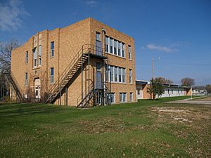
Former Argusville High School, demolished in 2023
|
|

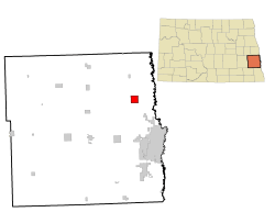
Location of Argusville, North Dakota
|
|
| Country | United States |
| State | North Dakota |
| County | Cass |
| Founded | 1881 |
| Area | |
| • Total | 4.00 sq mi (10.37 km2) |
| • Land | 4.00 sq mi (10.37 km2) |
| • Water | 0.00 sq mi (0.00 km2) |
| Elevation | 886 ft (270 m) |
| Population
(2020)
|
|
| • Total | 480 |
| • Estimate
(2022)
|
476 |
| • Density | 119.94/sq mi (46.31/km2) |
| Time zone | UTC-6 (Central (CST)) |
| • Summer (DST) | UTC-5 (CDT) |
| ZIP code |
58005
|
| Area code(s) | 701 |
| FIPS code | 38-03020 |
| GNIS feature ID | 1035914 |
Argusville is a small city in Cass County, North Dakota, United States. In 2020, about 480 people lived there. The city was founded in 1881. Its population grew quite a bit from 2004 to 2008 because many new houses were built.
Contents
History of Argusville
Argusville was officially planned out in 1881. This happened when the railroad tracks reached that area. The city probably got its name from a local newspaper called the Daily Argus. A post office opened in Argusville in 1881. It stayed open for many years, until 1982.
In 1890, Argusville experienced a very strong tornado. It was one of the deadliest tornadoes in North Dakota at that time. Seven people lost their lives during this natural disaster.
Geography of Argusville
Argusville covers an area of about 4 square miles (10.37 square kilometers). All of this area is land. There are no large lakes or rivers within the city limits.
Population and People
The number of people living in Argusville has changed over the years. Here's a quick look at the population from different census years:
| Historical population | |||
|---|---|---|---|
| Census | Pop. | %± | |
| 1930 | 115 | — | |
| 1940 | 145 | 26.1% | |
| 1950 | 126 | −13.1% | |
| 1960 | 118 | −6.3% | |
| 1970 | 118 | 0.0% | |
| 1980 | 147 | 24.6% | |
| 1990 | 161 | 9.5% | |
| 2000 | 147 | −8.7% | |
| 2010 | 475 | 223.1% | |
| 2020 | 480 | 1.1% | |
| 2022 (est.) | 476 | 0.2% | |
| U.S. Decennial Census 2020 Census |
|||
What the 2010 Census Showed
In 2010, there were 475 people living in Argusville. These people lived in 151 households. Most of the households, 128, were families. The city had about 118 people per square mile.
Most people in Argusville were White (97.9%). A small number were Native American (1.5%) or African American (0.2%). Some people were from two or more races (0.4%).
Many households (58.9%) had children under 18 living with them. Most families (76.8%) were married couples living together. The average household had about 3.15 people.
The average age in Argusville was 31.7 years old. About 38.7% of residents were under 18. About 38.1% were between 25 and 44 years old.
Getting Around
The Amtrak Empire Builder train passes through Argusville. This train travels between Seattle/Portland and Chicago. However, the train does not stop in Argusville. The closest train station is in Fargo, which is about 16 miles south.
See also
 In Spanish: Argusville (Dakota del Norte) para niños
 | Stephanie Wilson |
 | Charles Bolden |
 | Ronald McNair |
 | Frederick D. Gregory |

