Horace, North Dakota facts for kids
Quick facts for kids
Horace, North Dakota
|
||
|---|---|---|
|
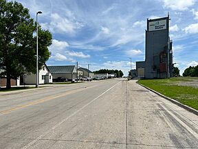
Near the grain elevator within Horace
U.S. Post Office in Horace, ND.
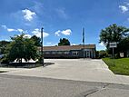
Horace Fire Station & Event Center on Main Street.
|
||
|
||
| Motto(s):
"Horizons Expand Here."
|
||

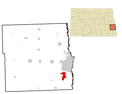
Location of Horace, North Dakota
|
||
| Country | United States | |
| State | North Dakota | |
| County | Cass | |
| Founded | 1882 | |
| Incorporated | 1940's | |
| Area | ||
| • City | 12.693 sq mi (32.875 km2) | |
| • Land | 12.690 sq mi (32.866 km2) | |
| • Water | 0.003 sq mi (0.071 km2) | |
| Elevation | 912 ft (278 m) | |
| Population
(2020)
|
||
| • City | 3,085 | |
| • Estimate
(2023)
|
5,643 | |
| • Density | 445.48/sq mi (172.01/km2) | |
| • Urban | 216,214 | |
| • Metro | 262,620 | |
| Time zone | UTC–6 (Central (CST)) | |
| • Summer (DST) | UTC–5 (CDT) | |
| ZIP Code |
58047
|
|
| Area code(s) | 701 | |
| FIPS code | 38-38900 | |
| GNIS feature ID | 1036095 | |
| Sales tax | 7.5% | |
Horace is a city in Cass County, North Dakota, United States. In 2020, about 3,085 people lived there.
Horace is a suburb of the Fargo-Moorhead area. It is the 14th largest city in North Dakota. The city was started in 1882 when many European-Americans were settling in the area.
Contents
History of Horace
A post office has been open in Horace since 1875. The city is named after Horace Greeley. He was an editor from New York. Greeley encouraged people to move west with his famous saying, "Go West, young man".
The Sheyenne River borders the city on its west side. This river sometimes caused big floods. To stop this, a special project was built from 1990 to 1992. It was called the Sheyenne Diversion Project. This project created a canal to move floodwaters away from Horace. It helped protect the city from floods, like the big one in 1997.
Geography of Horace
Horace covers about 12.69 square miles (32.87 square kilometers). Most of this area is land. Only a very small part is water.
Population and People
| Historical population | |||
|---|---|---|---|
| Census | Pop. | %± | |
| 1950 | 190 | — | |
| 1960 | 178 | −6.3% | |
| 1970 | 276 | 55.1% | |
| 1980 | 494 | 79.0% | |
| 1990 | 662 | 34.0% | |
| 2000 | 915 | 38.2% | |
| 2010 | 2,430 | 165.6% | |
| 2020 | 3,085 | 27.0% | |
| 2023 (est.) | 5,643 | 132.2% | |
| U.S. Decennial Census 2020 Census 6,441 population in Horace in 2024 est. |
|||
In 2022, there were about 1,240 households in Horace. Each household had about 2.79 people. The average income for a household was about $146,184.
About 5.3% of the people in Horace live below the poverty line. About 77.9% of people have jobs. Also, 42.8% of people have a college degree or higher. Almost everyone, 98.4%, has a high school diploma.
The average age of people in Horace was 36.3 years.
Population in 2020
In 2020, Horace had 3,085 people. There were 1,049 households and 868 families. Most people, about 93.16%, were White. About 1.91% of the population was Hispanic or Latino.
About 33.9% of residents were under 18 years old. About 9.3% were under 5 years old. And 6.4% were 65 years or older.
Population in 2010
In 2010, Horace had 2,430 people. There were 810 households and 682 families. Most people, about 97.08%, were White. About 0.91% of the population was Hispanic or Latino.
In 50.1% of households, there were children under 18. Most households, 74.4%, were married couples. The average household had 3 people.
The average age in 2010 was 35.6 years. About 33.4% of residents were under 18. About 4.9% were 65 or older. There were slightly more males (50.6%) than females (49.4%).
See also
 In Spanish: Horace (Dakota del Norte) para niños
 | Janet Taylor Pickett |
 | Synthia Saint James |
 | Howardena Pindell |
 | Faith Ringgold |


