
Wild Rice River (North Dakota) facts for kids
Quick facts for kids Wild Rice River |
|
|---|---|

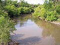
The Wild Rice River near Abercrombie in 2007
|
|

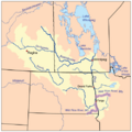
The Red River drainage basin, with the Wild Rice Rivers of North Dakota and Minnesota highlighted
|
|
| Country | United States |
| State | North Dakota |
| Physical characteristics | |
| Main source | Brampton Township, Sargent County 1,283 ft (391 m) 46°00′56″N 97°47′08″W / 46.01556°N 97.78556°W |
| River mouth | Red River of the North near Frontier, Cass County 879 ft (268 m) 46°45′24″N 96°47′24″W / 46.75667°N 96.79000°W |
| Length | 251 mi (404 km) |
| Discharge (location 2) |
|
| Basin features | |
| Basin size | 2,233 sq mi (5,780 km2) |
The Wild Rice River is a river in southeastern North Dakota, United States. It is about 251 miles (404 km) long. This river flows into the Red River of the North.
The Wild Rice River is part of a larger water system. Its water eventually reaches Hudson Bay through the Red River, Lake Winnipeg, and the Nelson River. The river and its smaller streams, called tributaries, drain an area of 2,233 square miles (5,783 km²). This area is mostly in the Red River Valley. Some of its tributaries also flow from a small part of northeastern South Dakota.
Even though it is quite long, the Wild Rice River is a fairly small stream. On average, it flows at about 100 cubic feet per second (3 cubic meters per second). The river got its name because there used to be a lot of wild rice growing along its banks.
Where Does the Wild Rice River Flow?

The Wild Rice River starts as a stream that sometimes dries up. It begins in Brampton Township in southeastern Sargent County. This is about 6 miles (10 km) south of Cogswell.
At first, the river flows mostly east. It winds its way through Sargent and Richland counties. Along its path, it goes through the Tewaukon National Wildlife Refuge. It also passes by the towns of Cayuga, Mantador, and Great Bend.
After Great Bend, the river turns north. From west of Wahpeton, it generally flows next to the Red River. It stays about 3 to 7 miles (5 to 11 km) away from the Red River. Finally, the Wild Rice River flows into the Red River in southeastern Cass County. This meeting point is about 3 miles (5 km) southeast of Frontier and 7 miles (11 km) south of Fargo.
How Fast Does the River Flow?
The United States Geological Survey (USGS) measures the river's flow. They have a special device called a stream gauge. This gauge is located 3.2 miles (5.1 km) northwest of Abercrombie.
From 1932 to 2005, the river's average flow at this spot was 104 cubic feet per second (3 cubic meters per second). The highest flow ever recorded there was on April 11, 1969, when it reached 9,540 cubic feet per second (270 cubic meters per second). Sometimes, the river has even been recorded with zero flow, meaning it was completely dry at that point.
There is another gauge further upstream near Rutland in Sargent County. Between 1960 and 1982, the average flow there was 8.36 cubic feet per second (0.237 cubic meters per second). On April 3, 1997, a high flow of 2,700 cubic feet per second (76 cubic meters per second) was recorded at this location.
Images for kids
-
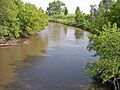
The Wild Rice River near Abercrombie in 2007
-
The Red River drainage basin, with the Wild Rice Rivers of North Dakota and Minnesota highlighted
-
The Wild Rice River near Abercrombie in 2007
