Spink County, South Dakota facts for kids
Quick facts for kids
Spink County
|
|
|---|---|

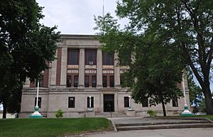
Spink County Courthouse (2013)
|
|

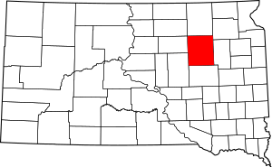
Location within the U.S. state of South Dakota
|
|
 South Dakota's location within the U.S. |
|
| Country | |
| State | |
| Founded | 1873 (created) 1879 (organized) |
| Named for | S.L. Spink |
| Seat | Redfield |
| Largest city | Redfield |
| Area | |
| • Total | 1,510 sq mi (3,900 km2) |
| • Land | 1,504 sq mi (3,900 km2) |
| • Water | 5.8 sq mi (15 km2) 0.4% |
| Population
(2020)
|
|
| • Total | 6,361 |
| • Estimate
(2023)
|
6,166 |
| • Density | 4.213/sq mi (1.626/km2) |
| Time zone | UTC−6 (Central) |
| • Summer (DST) | UTC−5 (CDT) |
| Congressional district | At-large |
Spink County is a county located in the state of South Dakota in the United States. In 2020, about 6,361 people lived here. The main town and county seat (where the county government is) is Redfield. Spink County was first created in 1873. It officially started working as a county in 1879, when it was part of Dakota Territory.
Exploring Spink County's Land
The land in Spink County has gentle, rolling hills. Most of this land is used for farming. The James River flows through the middle of the county, heading south. The highest point in the county is in its northeast corner. It is about 1,424 ft (434 m) above sea level.
The county covers a total area of about 1,510 square miles (3,900 km2). Most of this is land (1,504 square miles (3,900 km2)), and a small part is water (5.8 square miles (15 km2)).
Main Roads in Spink County
Special Nature Areas
- Fisher Grove State Park is a protected area in the county. It's a great place to enjoy nature.
Neighboring Counties
Spink County shares its borders with several other counties:
- Brown County to the north
- Day County to the northeast
- Clark County to the east
- Beadle County to the south
- Hand County to the southwest
- Faulk County to the west
Lakes in Spink County
You can find these lakes in the county:
- Alkali Lake
- Cottonwood Lake
- Twin Lakes
People of Spink County
The number of people living in Spink County has changed over many years. Here's a look at the population from past censuses:
| Historical population | |||
|---|---|---|---|
| Census | Pop. | %± | |
| 1880 | 477 | — | |
| 1890 | 10,581 | 2,118.2% | |
| 1900 | 9,487 | −10.3% | |
| 1910 | 15,981 | 68.5% | |
| 1920 | 15,768 | −1.3% | |
| 1930 | 15,304 | −2.9% | |
| 1940 | 12,527 | −18.1% | |
| 1950 | 12,204 | −2.6% | |
| 1960 | 11,706 | −4.1% | |
| 1970 | 10,595 | −9.5% | |
| 1980 | 9,201 | −13.2% | |
| 1990 | 7,981 | −13.3% | |
| 2000 | 7,454 | −6.6% | |
| 2010 | 6,415 | −13.9% | |
| 2020 | 6,361 | −0.8% | |
| 2023 (est.) | 6,166 | −3.9% | |
| U.S. Decennial Census | |||
Recent Population Data
According to the 2020 census, there were 6,361 people living in Spink County. These people lived in 2,520 households, and 1,560 of these were families.
In the 2010 census, there were 6,415 people. Most people (97.1%) were white. About 1.2% were Native American. A small number of people were from other racial backgrounds. About 1.1% of the population was of Hispanic or Latino origin.
The average age of people in Spink County in 2010 was 44.4 years old. Many families in the county were married couples living together.
Spink County is also home to several Hutterite communities. These communities are found near towns like Ashton and Stratford.
Towns and Communities
Spink County has several towns and communities where people live and work.
Cities in Spink County
Smaller Towns
Census-Designated Places
These are areas that are like towns but are not officially incorporated as cities or towns.
- Camrose Colony
- Clark Colony
- Glendale Colony
- Hillside Colony
- Mansfield (partially in another county)
- Spink Colony
Other Small Communities
- Athol
- Crandon
Townships in Spink County
Townships are smaller local government areas within the county.
- Antelope
- Athol
- Belle Plaine
- Belmont
- Benton
- Beotia
- Buffalo
- Capitola
- Clifton
- Conde
- Cornwall
- Crandon
- Exline
- Frankfort
- Garfield
- Great Bend
- Groveland
- Harmony
- Harrison
- Jefferson
- Lake
- La Prairie
- Lincoln
- Lodi
- Mellette
- Northville
- Olean
- Prairie Center
- Redfield
- Richfield
- Spring
- Sumner
- Tetonka
- Three Rivers
- Tulare
- Turton
- Union
See also
 In Spanish: Condado de Spink para niños
 | Tommie Smith |
 | Simone Manuel |
 | Shani Davis |
 | Simone Biles |
 | Alice Coachman |

