Coteau du Missouri facts for kids
The Coteau du Missouri, also called the Missouri Plateau, is a big, flat area of land. It stretches along the eastern side of the Missouri River valley. You can find it in central North Dakota and north-central South Dakota in the United States.
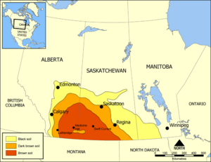
This land also extends into Canada. In the provinces of Saskatchewan and Alberta, it's known as the uplands Missouri Coteau. It's part of the larger Great Plains region. Long ago, in Canada, this area was called Palliser's Triangle. An explorer named John Palliser thought it wasn't good for farming.
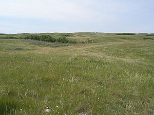
The Coteau du Missouri has gently rolling hills and many small potholes, which are like small ponds. It's mostly covered in grasslands. Besides being a geographical area, this plateau is important to the Indigenous peoples who live there, including the Métis people of South Dakota.
Contents
What is the Coteau du Missouri?
The Coteau du Missouri is a large plateau. A plateau is a flat area of land that is higher than the land around it. This plateau is part of the bigger Great Plains region. The Missouri River Trench, which is a deep valley, separates it from the main plateau to the west.
How was the land formed?
The land here was shaped by many glaciers over a long time. Underneath the surface, there's a type of rock called shale. On top of this, there are hard layers left behind by the glaciers. This area was covered by glaciers, unlike some nearby places that were not.
What resources are found here?
The Coteau du Missouri also has some natural resources. You can find deposits of lignite, which is a type of coal. There's also mirabilite, which is a mineral used to make sodium sulfate. Another mineral found here is bentonite, a type of clay.
Farming and Growing Conditions
Farming in the Coteau du Missouri can be challenging. This is because of the weather and the special conditions of the soil. The land does not drain water very well. This means water from glaciers often sits in low spots.
Why is drainage poor?
The poor drainage is partly because the Coteau du Missouri is close to the kettle lakes region. Kettle lakes are small, shallow lakes formed by melting glaciers. Several wide, shallow valleys cross the plateau. These valleys were once ancient river paths. Rivers like the Grand, Moreau, Cheyenne, Bad, and White used to flow through them.
What grows here?
To the east, the low valley of the James River separates the Coteau du Missouri from another plateau called the Coteau des Prairies. This valley was formed by the most recent ice age. The Coteau du Missouri is connected to the Canadian prairies. It has very few forests and is mostly flat land. Because of the tough conditions, farmers mainly grow grains and raise livestock here.
See also
 In Spanish: Meseta de Misuri para niños
 | Victor J. Glover |
 | Yvonne Cagle |
 | Jeanette Epps |
 | Bernard A. Harris Jr. |


