Minnehaha County, South Dakota facts for kids
Quick facts for kids
Minnehaha County
|
|
|---|---|
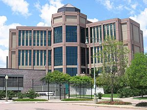
Minnehaha County Courthouse in Sioux Falls
|
|
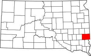
Location within the U.S. state of South Dakota
|
|
 South Dakota's location within the U.S. |
|
| Country | |
| State | |
| Founded | 1862 (created) 1868 (organized) |
| Named for | "rapid water" |
| Seat | Sioux Falls |
| Largest city | Sioux Falls |
| Area | |
| • Total | 814 sq mi (2,110 km2) |
| • Land | 807 sq mi (2,090 km2) |
| • Water | 6.7 sq mi (17 km2) 0.8% |
| Population
(2020)
|
|
| • Total | 197,214 |
| • Estimate
(2023)
|
206,930 |
| • Density | 239/sq mi (92/km2) |
| Time zone | UTC−6 (Central) |
| • Summer (DST) | UTC−5 (CDT) |
| Congressional district | At-large |
Minnehaha County is a county located on the eastern edge of South Dakota. It's the most populated county in the state. In 2020, about 197,214 people lived here. This means over 20% of South Dakota's population calls Minnehaha County home!
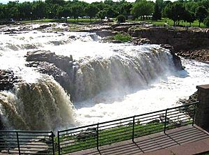
The main city and county seat is Sioux Falls. This is also the largest city in South Dakota. The county was officially started in 1862 and organized in 1868. Its name comes from the Sioux word Mnihaha. This word means "rapid water" or "waterfall." Sometimes, people mistakenly translate it as "laughing water."
Minnehaha County is part of the Sioux Falls Metropolitan Statistical Area. This is the biggest city area in South Dakota.
Contents
Geography of Minnehaha County
Minnehaha County is in eastern South Dakota. Its eastern border touches Minnesota and Iowa. The Big Sioux River flows through the middle-eastern part of the county, heading south.
The land here has rolling hills. Most of it is used for farming, except for the cities and towns. You'll also find many lakes and ponds in the western part. The land generally slopes towards the south. The highest point is in the northwest corner, about 1,752 feet (534 meters) above sea level.
Minnehaha County covers an area of 814 square miles (2,108 square kilometers). Out of this, 807 square miles (2,090 square kilometers) is land. Only 6.7 square miles (17 square kilometers) is water.
Main Roads
 I-29
I-29 I-90
I-90 I-229
I-229 South Dakota Highway 11
 South Dakota Highway 42
Transportation
- Jefferson Lines (bus service) at Sioux Falls Bus Station
- Sioux Area Metro (local bus service)
Airports
- Sioux Falls Regional Airport (FSD)
- Wheelborg Landing Field (a small airport near Dell Rapids)
Fun Outdoor Places
- Beaver Creek State Recreation Area
- Big Sioux State Recreation Area
- Falls Park
- Palisades State Park
- Wall Lake State Lakeside Use Area
Lakes and Rivers
- Beaver Creek
- Beaver Lake
- Big Sioux River
- Buffalo Lake
- Clear Lake
- Covell Lake
- Diamond Lake
- Grass Lake
- Island Lake (part)
- Lake Lorane
- Loss Lake
- Lost Lake
- Scott Lake
- Skunk Creek
- Split Rock Creek
- Twin Lake
- Wall Lake
People of Minnehaha County
| Historical population | |||
|---|---|---|---|
| Census | Pop. | %± | |
| 1870 | 355 | — | |
| 1880 | 8,251 | 2,224.2% | |
| 1890 | 21,879 | 165.2% | |
| 1900 | 23,926 | 9.4% | |
| 1910 | 29,631 | 23.8% | |
| 1920 | 42,490 | 43.4% | |
| 1930 | 50,872 | 19.7% | |
| 1940 | 57,697 | 13.4% | |
| 1950 | 70,910 | 22.9% | |
| 1960 | 86,575 | 22.1% | |
| 1970 | 95,209 | 10.0% | |
| 1980 | 109,435 | 14.9% | |
| 1990 | 123,809 | 13.1% | |
| 2000 | 148,281 | 19.8% | |
| 2010 | 169,468 | 14.3% | |
| 2020 | 197,214 | 16.4% | |
| 2023 (est.) | 206,930 | 22.1% | |
| U.S. Decennial Census 1790-1960 1900-1990 1990-2000 2010-2020 |
|||
Population in 2020
In 2020, the county had 197,214 people. There were 78,715 households, which are groups of people living together. The population density was about 244 people per square mile.
Population in 2010
Back in 2010, there were 169,468 people living in Minnehaha County. Most people (88.1%) were white. Other groups included Black or African American (3.8%), American Indian (2.5%), and Asian (1.5%). About 4.1% of the population was of Hispanic or Latino background.
Many people in the county have German (43.8%) or Norwegian (17.7%) family roots. The average age of people in the county was 34.5 years old.
Communities in Minnehaha County
Minnehaha County has several cities, towns, and smaller communities.
Cities
- Baltic
- Brandon
- Colton
- Crooks
- Dell Rapids
- Garretson
- Hartford
- Sioux Falls (This is the county seat!)
- Valley Springs
Towns
Small Communities (CDPs)
These are areas where many people live, but they are not officially cities or towns.
Other Small Places (Unincorporated)
These are even smaller communities that are not officially organized.
Old Town Sites
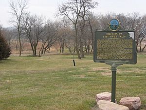
Some towns that used to exist in Minnehaha County are now historical sites.
- East Sioux Falls
- Eminija
- South Sioux Falls
- West Sioux Falls
- Wingert
Schools in Minnehaha County
Many school districts serve the students in Minnehaha County.
- Baltic School District 49-1
- Brandon Valley School District 49-2
- Canton School District 41-1
- Chester School District 39-1
- Dell Rapids School District 49-3
- Garretson School District 49-4
- Harrisburg School District 41-2
- Lennox School District 41-4
- Montrose School District 43-2
- Parker School District 60-4
- Sioux Falls School District 49-5
- Tea Area School District 41-5
- Tri-Valley School District 49-6
- West Central School District 49-7
In the past, there were also many smaller, rural schools throughout the county.
See also
 In Spanish: Condado de Minnehaha para niños
 | Toni Morrison |
 | Barack Obama |
 | Martin Luther King Jr. |
 | Ralph Bunche |


