
Cottonwood County, Minnesota facts for kids
Quick facts for kids
Cottonwood County
|
|
|---|---|

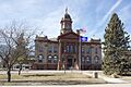
Cottonwood County Courthouse
|
|

Location within the U.S. state of Minnesota
|
|
 Minnesota's location within the U.S. |
|
| Country | |
| State | |
| Founded | May 23, 1857 (created) July 29, 1870 (organized) |
| Named for | Cottonwood River |
| Seat | Windom |
| Largest city | Windom |
| Area | |
| • Total | 649 sq mi (1,680 km2) |
| • Land | 639 sq mi (1,660 km2) |
| • Water | 10 sq mi (30 km2) 1.5%% |
| Population
(2020)
|
|
| • Total | 11,517 |
| • Estimate
(2023)
|
11,319 |
| • Density | 18.0/sq mi (6.9/km2) |
| Time zone | UTC−6 (Central) |
| • Summer (DST) | UTC−5 (CDT) |
| Congressional districts | 1st, 7th |
Cottonwood County is a county in the state of Minnesota. In 2020, about 11,517 people lived here. The main town and county seat is Windom.
Contents
Cottonwood County History
Cottonwood County was officially created on May 23, 1857. It got its name from the Cottonwood River. The word "Waraju" in the Dakota Sioux language means "cottonwood."
Minnesota Governor Horace Austin chose three people to be the first county commissioners. They met near Windom to set up the county. They decided on different areas for the commissioners and changed some county jobs. The county was fully organized on July 29, 1870. The first election for the county was held that November. The first land records were made in 1870. People started paying taxes on their land in 1872.
Important Places in History
Several important places in Cottonwood County are listed on the National Register of Historic Places. This means they are special and protected because of their history.
- The Cottonwood County Courthouse was built in 1904. It's a great example of Neoclassical architecture, a style that looks like old Greek and Roman buildings.
- Mountain Park is southeast of Mountain Lake. It was added to the National Register in 1973. In 1976, scientists found signs of an ancient village there. It was home to the Meskwaki people around 500 B.C. This is the oldest human settlement found in Minnesota!
- The Jeffers Petroglyphs, near Jeffers, are ancient rock carvings. Native Americans made these carvings long before Europeans came to America. They are also listed on the National Register of Historic Places.
Cottonwood County Geography
Cottonwood County has low, rolling hills. Most of the land is used for farming. The land generally slopes towards the east. The highest point in the county is about 1,535 feet (468 meters) above sea level. The county covers about 649 square miles. Most of this (639 square miles) is land, and a small part (10 square miles) is water.
Rivers and Waterways
The northeastern part of the county drains into the Minnesota River. This happens through many small creeks and the Cottonwood River and Watonwan River. The southwestern part of the county drains into the Des Moines River. Both of these watersheds eventually flow into the Mississippi River in Iowa. Many wetlands in the county have been drained to create more farmland.
Lakes in Cottonwood County
Here are some of the lakes found in Cottonwood County:
| Des Moines River Watershed | Minnesota River Watershed |
|---|---|
|
|
Main Roads
 U.S. Highway 71
 Minnesota State Highway 30
 Minnesota State Highway 60
 Minnesota State Highway 62
Neighboring Counties
- Redwood County - north
- Brown County - northeast
- Watonwan County - east
- Jackson County - south
- Nobles County - southwest
- Murray County -west
Protected Natural Areas
Cottonwood County has many protected areas. These include Wildlife Management Areas (WMAs), Waterfowl Production Areas (WPAs), and Scientific and Natural Areas (SNAs). These places help protect local wildlife and nature.
- Arnolds Lake WMA
- Banks WMA
- Bennett WMA
- Blixseth WPA
- Budolfson WMA
- Carpenter WMA
- Clear Lake WPA
- Cottonwood Lake WPA
- Delft State Wildlife Management Area
- Des Moines River WPA
- Dynamite Park
- Expandere WMA
- Farhagen WMA
- Harder Lake WPA
- Hurricane Lake WMA
- Lady Bird County Park
- Lake Augusta WPA
- Little Swan Lake State Wildlife Management Area
- Long Lake WPA
- Mound Creek County Park
- Mountain County Park
- Mountain Lake WMA
- Mountain Lake WPA
- Pats Grove County Park
- Pats Pasture WMA
- Pennington Prairie SNA
- Regehr State Wildlife Management Area
- Red Rock Falls County Park
- Rock Ridge Prairie Scientific and Natural Area
- Rock Ridge WMA
- South Dutch Charlie County Park
- String Lakes WMA
- Storden WPA
- Talcot County Park
- Talcot Lake WMA
- Typhoon WMA
- Voit WMA
- Watonwan WPA
- Wolf Lake WPA
Cottonwood County Population
| Historical population | |||
|---|---|---|---|
| Census | Pop. | %± | |
| 1860 | 12 | — | |
| 1870 | 534 | 4,350.0% | |
| 1880 | 5,533 | 936.1% | |
| 1890 | 7,412 | 34.0% | |
| 1900 | 12,069 | 62.8% | |
| 1910 | 12,651 | 4.8% | |
| 1920 | 14,570 | 15.2% | |
| 1930 | 14,782 | 1.5% | |
| 1940 | 16,143 | 9.2% | |
| 1950 | 15,763 | −2.4% | |
| 1960 | 16,166 | 2.6% | |
| 1970 | 14,887 | −7.9% | |
| 1980 | 14,854 | −0.2% | |
| 1990 | 12,694 | −14.5% | |
| 2000 | 12,167 | −4.2% | |
| 2010 | 11,687 | −3.9% | |
| 2020 | 11,517 | −1.5% | |
| 2023 (est.) | 11,319 | −3.1% | |
| U.S. Decennial Census 1790-1960 1900-1990 1990-2000 2010-2020 |
|||
The population of Cottonwood County has changed over the years. In 2020, the county had 11,517 people.
People in Cottonwood County (2020 Census)
Here's a look at the different groups of people living in Cottonwood County, based on the 2020 census:
| Race | Num. | Perc. |
|---|---|---|
| White (NH) | 9,418 | 82% |
| Black or African American (NH) | 135 | 1.2% |
| Native American (NH) | 25 | 0.22% |
| Asian (NH) | 361 | 3.13% |
| Pacific Islander (NH) | 80 | 0.7% |
| Other/Mixed (NH) | 383 | 3.33% |
| Hispanic or Latino | 1,115 | 9.7% |
Communities in Cottonwood County
Cities
Unincorporated Community
- Delft (This is a small community that is not officially a city.)
Townships
Townships are smaller local government areas within the county.
- Amboy Township
- Amo Township
- Ann Township
- Carson Township
- Dale Township
- Delton Township
- Germantown Township
- Great Bend Township
- Highwater Township
- Lakeside Township
- Midway Township
- Mountain Lake Township
- Rose Hill Township
- Selma Township
- Southbrook Township
- Springfield Township
- Storden Township
- Westbrook Township
Images for kids
-
The Cottonwood County Courthouse, built in 1904.
See also
 In Spanish: Condado de Cottonwood para niños
