
Redwood County, Minnesota facts for kids
Quick facts for kids
Redwood County
|
|
|---|---|

|
|

Location within the U.S. state of Minnesota
|
|
 Minnesota's location within the U.S. |
|
| Country | |
| State | |
| Founded | February 6, 1862 |
| Named for | Redwood River |
| Seat | Redwood Falls |
| Largest city | Redwood Falls |
| Area | |
| • Total | 882 sq mi (2,280 km2) |
| • Land | 879 sq mi (2,280 km2) |
| • Water | 3.2 sq mi (8 km2) 0.4%% |
| Population
(2020)
|
|
| • Total | 15,425 |
| • Estimate
(2023)
|
15,288 |
| • Density | 17.5/sq mi (6.8/km2) |
| Time zone | UTC−6 (Central) |
| • Summer (DST) | UTC−5 (CDT) |
| Congressional district | 7th |
Redwood County is a county located in the state of Minnesota in the United States. In 2020, about 15,425 people lived here. The main city and county seat is Redwood Falls. This city is found along the Redwood River, close to where it joins the Minnesota River.
A special place called the Lower Sioux Indian Reservation is completely inside Redwood County. This reservation is home to the Mdewakanton Dakota people. It is located along the southern side of the Minnesota River.
Contents
History of Redwood County
Redwood County was officially created by the Minnesota Legislature on February 8, 1862. The city of Redwood Falls was chosen as its county seat right from the start. The county got its name from the Redwood River, which flows through the area.
Geography and Nature
Redwood County is a place with rolling hills and many rivers and lakes. The Minnesota River flows along the county's northeastern edge. The Redwood River flows east through the northern part of the county. It empties into the Minnesota River near Redwood Falls. Another river, the Cottonwood River, flows through the southern part of the county.
Most of Redwood County is rural, meaning it's mostly countryside. Farmers here grow important crops like corn and soybeans. The highest point in the county is in the southwest corner, about 1,450 feet (442 meters) above sea level. The county covers a total area of 882 square miles (2,284 square kilometers). Most of this area is land, with a small part being water.
Rivers and Lakes in Redwood County
Redwood County has several lakes and rivers that are important to its geography.
- Daubs Lake
- Gales Lake
- Lake Francis
- Lake Redwood
- Long Lake
- Three Lakes
- Tiger Lake
Parks and Natural Areas
Redwood County is home to several protected areas. These places help keep nature safe and offer chances to explore the outdoors.
- Alexander Ramsey State Park
- Cedar Mountain Scientific and Natural Area
- Cedar Rock Scientific and Natural Area
- Daubs Lake State Wildlife Management Area
- Delhi State Wildlife Management Area
- Gales State Wildlife Management Area
- Honner State Wildlife Management Area
- Klabunde State Wildlife Management Area
- Luescher-Barnum State Wildlife Management Area
- Mammenga State Wildlife Management Area
- Paul State Wildlife Management Area
- Rohlik State Wildlife Management Area
- Swedes Forest Scientific and Natural Area (part)
- Waterbury State Wildlife Management Area
- Westline State Wildlife Management Area
- Willow Lake State Wildlife Management Area
Transportation
Getting around Redwood County is made easier by its roads and an airport.
Main Roads
Several important highways pass through Redwood County. These roads connect the county to other parts of Minnesota and beyond.
 U.S. Highway 14
 U.S. Highway 71
 Minnesota State Highway 19
 Minnesota State Highway 67
 Minnesota State Highway 68
 Minnesota State Highway 330
Local Airport
- Redwood Falls Municipal Airport (RWF)
Neighboring Counties
Redwood County shares its borders with several other counties in Minnesota.
- Renville County - to the northeast
- Brown County - to the east
- Cottonwood County - to the south
- Murray County - to the southwest
- Lyon County - to the west
- Yellow Medicine County - to the northwest
Population and People
The number of people living in Redwood County has changed over time. The U.S. Census counts the population every ten years.
| Historical population | |||
|---|---|---|---|
| Census | Pop. | %± | |
| 1870 | 1,829 | — | |
| 1880 | 5,375 | 193.9% | |
| 1890 | 9,886 | 83.9% | |
| 1900 | 17,261 | 74.6% | |
| 1910 | 18,425 | 6.7% | |
| 1920 | 20,908 | 13.5% | |
| 1930 | 20,620 | −1.4% | |
| 1940 | 22,290 | 8.1% | |
| 1950 | 22,127 | −0.7% | |
| 1960 | 21,718 | −1.8% | |
| 1970 | 20,024 | −7.8% | |
| 1980 | 19,341 | −3.4% | |
| 1990 | 17,254 | −10.8% | |
| 2000 | 16,815 | −2.5% | |
| 2010 | 16,059 | −4.5% | |
| 2020 | 15,425 | −3.9% | |
| 2023 (est.) | 15,288 | −4.8% | |
| U.S. Decennial Census 1790-1960 1900-1990 1990-2000 2010-2020 |
|||
People in 2020
In the 2020 Census, the people living in Redwood County were counted by their race and ethnicity.
| Race | Number | Percentage |
|---|---|---|
| White | 13,123 | 85.1% |
| Black or African American | 76 | 0.5% |
| Native American | 774 | 5.02% |
| Asian | 414 | 2.7% |
| Pacific Islander | 1 | 0.01% |
| Other/Mixed | 541 | 3.51% |
| Hispanic or Latino | 496 | 3.22% |
Cities and Towns
Redwood County has several cities and smaller communities.

Cities in Redwood County
- Belview
- Clements
- Delhi
- Lamberton
- Lucan
- Milroy
- Morgan
- Redwood Falls (This is the county seat)
- Revere
- Sanborn
- Seaforth
- Vesta
- Wabasso
- Walnut Grove
- Wanda
Other Communities
These are smaller places that are not officially cities.
Images for kids
-
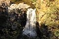
Ramsey Falls

See also
 In Spanish: Condado de Redwood para niños
