Redwood River facts for kids
Quick facts for kids Redwood River |
|
|---|---|

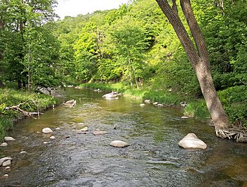
The Redwood River in Camden State Park in 2007
|
|
 |
|
| Country | United States |
| State | Minnesota |
| Physical characteristics | |
| Main source | Aetna Township, Pipestone County 1,909 ft (582 m) 44°10′03″N 96°10′18″W / 44.16750°N 96.17167°W |
| River mouth | Minnesota River near Redwood Falls, Redwood County 827 ft (252 m) 44°34′16″N 95°05′18″W / 44.57111°N 95.08833°W |
| Length | 127.1 mi (204.5 km) |
| Discharge (location 2) |
|
| Basin features | |
| Basin size | 705 sq mi (1,830 km2) |
The Redwood River is a river in southwestern Minnesota, United States. It flows for about 127 miles (205 km). The river is a tributary, which means it's a smaller river that flows into a larger one. The Redwood River flows into the Minnesota River.
The Redwood River is part of a huge watershed that eventually leads to the Mississippi River. A watershed is an area of land where all the water drains into a single river or lake. The Redwood River watershed covers about 705 square miles (1,826 km²). This area is mostly used for farming. People think the river got its name from the reddish bark of dogwood plants that grow along its banks.
Contents
Where Does the Redwood River Start and Flow?
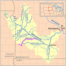
The Redwood River begins in Aetna Township in Pipestone County. This area is on a high, hilly landform called the Coteau des Prairies. This plateau divides the land where water flows towards the Mississippi River from where it flows towards the Missouri River.
The River's Journey Through Minnesota
When the river first starts, it flows east as a stream that sometimes dries up. It goes through Ruthton and into Murray County. Then, it turns north into Lyon County. Here, it changes direction again, flowing northeast through towns like Russell, Lynd, and Marshall.
The Scenic Valley and State Park
Between Russell and Marshall, the Redwood River flows down from the Coteau des Prairies. It drops about 300 feet (90 m) over 15 miles (24 km) in a beautiful wooded valley. Camden State Park is a great place to visit along this part of the river.
Flowing East to the Minnesota River
After Marshall, the Redwood River flows through a flat farming area. It turns east into Redwood County, passing through Vesta and Seaforth. In some parts of this area, the river has been straightened into ditches to help with farming.
The Final Stretch and Waterfalls
In Redwood Falls, the river enters the wooded valley of the Minnesota River. Here, the Redwood River drops 100 feet (30 m) in just one mile (2 km) over granite rocks. You can see this in Alexander Ramsey City Park. Soon after, the Redwood River flows into the Minnesota River.
Redwood Lake and Its Purpose
There's a dam in Redwood Falls that creates Redwood Lake. This dam used to help make electricity. Now, it's kept mainly to make sure the lake stays there for people to enjoy for fun activities.
What Rivers Join the Redwood River?
Several smaller rivers and creeks flow into the Redwood River. These are called tributaries.
- Coon Creek: This creek is about 37 miles (60 km) long. It starts at Lake Benton in Lincoln County and flows west to Russell in Lyon County before joining the Redwood River.
- Three Mile Creek: This creek is about 50 miles (81 km) long. It also starts in Lincoln County and flows northeast and southeast through Lyon County. It joins the Redwood River after Marshall.
- Ramsey Creek: This creek is 10 miles (16 km) long. It has a waterfall in Ramsey City Park in Redwood Falls, right before it joins the Redwood River.
How Does Farming Affect the River?
A large part of the land in the Redwood River watershed, about 82%, is used for farming. Farmers mainly grow corn and soybeans here. Many miles of the natural streams in this area have been changed into farm ditches. This can harm the homes of animals and plants in the river. It also makes it harder for the land to soak up water, which can lead to more flooding.
How Much Water Flows in the Redwood River?
Scientists measure how much water flows in rivers using special tools called stream gauges.
Water Flow Near Redwood Falls
Near Redwood Falls, about 8.5 miles (13.7 km) from where the river joins the Minnesota River, the average water flow between 1909 and 2005 was about 153 cubic feet per second (4 m³/s). To give you an idea, one cubic foot is about the size of a basketball. The most water ever recorded flowing there was 19,700 cubic feet per second (558 m³/s) on June 18, 1957. Sometimes, like in 1940 and 1959, the river had no water flowing at all on certain days.
Water Flow Near Marshall
Further upstream, near Marshall, the average water flow between 1940 and 2005 was about 69.5 cubic feet per second (2 m³/s). The highest flow recorded there was 6,380 cubic feet per second (181 m³/s) on May 9, 1993. Like near Redwood Falls, there were many days in several years when no water was flowing at this spot either.
 | Valerie Thomas |
 | Frederick McKinley Jones |
 | George Edward Alcorn Jr. |
 | Thomas Mensah |

