Murray County, Minnesota facts for kids
Quick facts for kids
Murray County
|
|
|---|---|

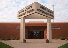
Murray County Government Center in Slayton, Minnesota
|
|

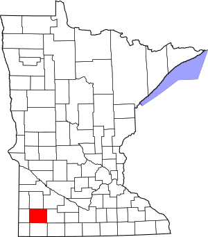
Location within the U.S. state of Minnesota
|
|
 Minnesota's location within the U.S. |
|
| Country | |
| State | |
| Founded | May 23 (created) June 17, 1872 (organized) |
| Named for | William Pitt Murray |
| Seat | Slayton |
| Largest city | Slayton |
| Area | |
| • Total | 720 sq mi (1,900 km2) |
| • Land | 705 sq mi (1,830 km2) |
| • Water | 15 sq mi (40 km2) 2.1%% |
| Population
(2020)
|
|
| • Total | 8,179 |
| • Estimate
(2023)
|
8,049 |
| • Density | 11.6/sq mi (4.5/km2) |
| Time zone | UTC−6 (Central) |
| • Summer (DST) | UTC−5 (CDT) |
| Congressional district | 7th |
Murray County is a place in the state of Minnesota, USA. It's like a smaller region within the state. In 2020, about 8,179 people lived here. The main town, or county seat, where the county government is located, is called Slayton.
Contents
History of Murray County
Murray County was officially created on May 23, 1857. Before that, it was part of other counties like Blue Earth County and Brown County.
The county government officially started on June 17, 1872. The first county seat was a town called Currie. Murray County was named after William Pitt Murray, who was an important leader in Minnesota's early days.
Later in 1872, a new town called Center was planned. It was named "Center" because it was in the middle of the county. This town grew quickly. In 1882, its name was changed to Slayton. People in Slayton wanted their town to be the county seat. After a vote, Slayton became the new county seat on June 1, 1889.
Murray County has also experienced some powerful storms. Two of the strongest tornadoes ever recorded in Minnesota happened here. These were the Chandler-Lake Wilson Tornado in 1992 and the Tracy Tornado in 1968.
Geography and Nature
Murray County has low, rolling hills and many lakes and ponds. Most of the land is used for farming. The land generally slopes down towards the south and east.
The highest point in the county is on a place called Buffalo Ridge. This ridge is a few hundred feet higher than the valleys around it. The county covers about 720 square miles. Most of this area (705 square miles) is land, and about 15 square miles (2.1%) is water.
A very important natural line, called the Mississippi-Missouri watershed divide, runs through the western part of the county. This means that rain falling on one side of the line flows to the Mississippi River, and rain on the other side flows to the Missouri River. The highest point in the county, at 1,920 feet above sea level, is on Buffalo Ridge.
Main Roads
 U.S. Highway 59
 Minnesota State Highway 30
 Minnesota State Highway 62
 Minnesota State Highway 91
 Minnesota State Highway 267
Airports
- Slayton Municipal Airport (DVP) - This airport is located southwest of Slayton, Minnesota.
Neighboring Counties
- Lyon County - to the north
- Redwood County - to the northeast
- Cottonwood County - to the east
- Nobles County - to the south
- Rock County - to the southwest
- Pipestone County - to the west
Protected Natural Areas
Murray County has many protected areas where nature is preserved. These include:
- Badger Lake State Wildlife Management Area
- Bergman State Wildlife Management Area
- Big Slough State Wildlife Management Area
- Buffalo Lake State Wildlife Management Area
- Chandler State Wildlife Management Area
- County Line State Wildlife Management Area
- Current Lake State Wildlife Management Area
- Great Oasis State Wildlife Management Area
- Haberman State Wildlife Management Area
- Hjermstad Lake State Wildlife Management Area
- Irruption State Wildlife Management Area
- Klinker State Wildlife Management Area
- Lake Shetek State Park
- Lange State Wildlife Management Area
- Leeds State Wildlife Management Area
- Lowville State Wildlife Management Area
- Mason State Wildlife Management Area
- McCord-Laible State Wildlife Management Area
- Nelson State Wildlife Management Area
- Northern Tallgrass Prairie National Wildlife Refuge
- Peters State Wildlife Management Area
- Phelan State Wildlife Management Area
- Reinhold State Wildlife Management Area
- Rupp State Wildlife Management Area
- Ruthton State Wildlife Management Area
- Schoeberl State Wildlife Management Area
- Shetek State Wildlife Management Area
- Sweetman State Wildlife Management Area
- Tutt State Wildlife Management Area
- Van Eck State Wildlife Management Area
Lakes in Murray County
- Bear Lake (this lake has been drained)
- Bloody Lake
- Buffalo Lake
- Corabelle Lake
- Current Lake
- Fox Lake
- Fulda First Lake
- Iron Lake
- Julia Lake (partly in Murray County)
- Lake Louisa
- Lake Maria
- Lake Sarah
- Lake Shetek
- Lake Wilson
- Lime Lake (also known as Lizzard Lake and Lake St. Rose)
- Long Lake (partly in Murray County)
- North Badger Lake
- Round Lake
- Smith Lake
- South Badger Lake
- Summit Lake
- Talcot Lake (partly in Murray County)
Population Information
| Historical population | |||
|---|---|---|---|
| Census | Pop. | %± | |
| 1860 | 29 | — | |
| 1870 | 209 | 620.7% | |
| 1880 | 3,604 | 1,624.4% | |
| 1890 | 6,692 | 85.7% | |
| 1900 | 11,911 | 78.0% | |
| 1910 | 11,755 | −1.3% | |
| 1920 | 13,631 | 16.0% | |
| 1930 | 13,902 | 2.0% | |
| 1940 | 15,060 | 8.3% | |
| 1950 | 14,801 | −1.7% | |
| 1960 | 14,743 | −0.4% | |
| 1970 | 12,508 | −15.2% | |
| 1980 | 11,507 | −8.0% | |
| 1990 | 9,660 | −16.1% | |
| 2000 | 9,165 | −5.1% | |
| 2010 | 8,725 | −4.8% | |
| 2020 | 8,179 | −6.3% | |
| 2023 (est.) | 8,049 | −7.7% | |
| U.S. Decennial Census 1790-1960 1900-1990 1990-2000 2010-2020 |
|||
Population in 2020
Here's a look at the different groups of people living in Murray County in 2020:
| Race | Number of People | Percentage |
|---|---|---|
| White (Non-Hispanic) | 7,483 | 91.5% |
| Black or African American (Non-Hispanic) | 26 | 0.32% |
| Native American (Non-Hispanic) | 9 | 0.11% |
| Asian (Non-Hispanic) | 105 | 1.3% |
| Pacific Islander (Non-Hispanic) | 3 | 0.03% |
| Other/Mixed (Non-Hispanic) | 171 | 2.1% |
| Hispanic or Latino | 382 | 4.7% |
Towns and Communities
Cities
Special Designated Area
Smaller Communities (Unincorporated)
These are places that are not officially cities or towns.
- Current Lake
- Lime Creek
- Lowville
- Owanka
- Wirock
Townships
Townships are smaller local government areas within the county.
- Belfast Township
- Bondin Township
- Cameron Township
- Chanarambie Township
- Des Moines River Township
- Dovray Township
- Ellsborough Township
- Fenton Township
- Holly Township
- Iona Township
- Lake Sarah Township
- Leeds Township
- Lime Lake Township
- Lowville Township
- Mason Township
- Moulton Township
- Murray Township
- Shetek Township
- Skandia Township
- Slayton Township
See also
 In Spanish: Condado de Murray (Minnesota) para niños
 | Janet Taylor Pickett |
 | Synthia Saint James |
 | Howardena Pindell |
 | Faith Ringgold |


