Pipestone County, Minnesota facts for kids
Quick facts for kids
Pipestone County
|
|
|---|---|

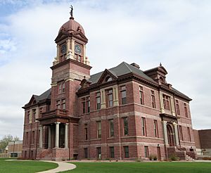
Pipestone County Courthouse
|
|

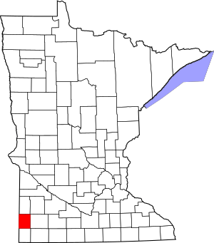
Location within the U.S. state of Minnesota
|
|
 Minnesota's location within the U.S. |
|
| Country | |
| State | |
| Founded | May 23, 1857 (created) 1879 (organized) |
| Named for | Pipestone |
| Seat | Pipestone |
| Largest city | Pipestone |
| Area | |
| • Total | 466 sq mi (1,210 km2) |
| • Land | 465 sq mi (1,200 km2) |
| • Water | 0.9 sq mi (2 km2) 0.2%% |
| Population
(2020)
|
|
| • Total | 9,424 |
| • Estimate
(2023)
|
9,245 |
| • Density | 20.3/sq mi (7.8/km2) |
| Time zone | UTC−6 (Central) |
| • Summer (DST) | UTC−5 (CDT) |
| Congressional district | 7th |
Pipestone County is a special area in the state of Minnesota, USA. It is called a county. In 2020, about 9,424 people lived here. The main city and government center is Pipestone.
Contents
History of Pipestone County
This county was officially started on May 23, 1857. At first, it was called Rock County. But there was a famous pipestone quarry here. So, in 1862, the names were swapped with the neighboring Rock County. This made sure the county with the pipestone quarry was named Pipestone County.
Pipestone County really started its government in 1879. The city of Pipestone became its main center. The name "Pipestone" comes from special red stones found here. Native Americans used these stones, called pipestone, to make pipes.
You can also find the Pipestone National Monument in the county. It is just north of the city of Pipestone.
Geography and Nature
Pipestone County is located right on Minnesota's border with South Dakota. The Rock River starts in this county. It then flows south into Rock County.
The land here has gentle, rolling hills. Farmers use most of the land for growing crops. The highest point in the county is about 1,995 feet (608 meters) above sea level. The county covers about 466 square miles. Most of this is land, with a small amount of water.
Main Roads in Pipestone County
These are the most important roads that go through Pipestone County:
 U.S. Highway 75
 Minnesota State Highway 23
 Minnesota State Highway 30
 Minnesota State Highway 269
Neighboring Counties
Pipestone County shares its borders with these other counties:
- Lincoln County (north)
- Lyon County (northeast)
- Murray County (east)
- Rock County (south)
- Minnehaha County, South Dakota (southwest)
- Moody County, South Dakota (west)
- Brookings County, South Dakota (northwest)
Special Protected Areas
Pipestone County has several areas set aside for nature and wildlife. These include:
- Altona State Wildlife Management Area
- Burke State Wildlife Management Area
- Holland State Wildlife Management Area
- Pheasant Terrace State Wildlife Management Area
- Pipestone Indian State Wildlife Management Area (inside Pipestone Natl Monument)
- Pipestone National Monument
- Prairie Coteau Scientific and Natural Area
- Split Rock Creek State Park
- Troy State Wildlife Management Area
- Van Beek State Wildlife Management Area
- Woodstock State Wildlife Management Area
Lakes and Water
Pipestone County is interesting because it does not have any natural lakes. Only a few counties in Minnesota are like this. However, it does have lakes that people created, called reservoirs. These include:
- Indian Lake
- Split Rock Lake (found in Split Rock Creek State Park)
People and Population (Demographics)
The number of people living in Pipestone County has changed over time. Here is a look at the population from different years:
| Historical population | |||
|---|---|---|---|
| Census | Pop. | %± | |
| 1880 | 2,092 | — | |
| 1890 | 5,132 | 145.3% | |
| 1900 | 9,264 | 80.5% | |
| 1910 | 9,553 | 3.1% | |
| 1920 | 12,050 | 26.1% | |
| 1930 | 12,238 | 1.6% | |
| 1940 | 13,794 | 12.7% | |
| 1950 | 14,003 | 1.5% | |
| 1960 | 13,605 | −2.8% | |
| 1970 | 12,791 | −6.0% | |
| 1980 | 11,690 | −8.6% | |
| 1990 | 10,491 | −10.3% | |
| 2000 | 9,895 | −5.7% | |
| 2010 | 9,596 | −3.0% | |
| 2020 | 9,424 | −1.8% | |
| 2023 (est.) | 9,245 | −3.7% | |
| U.S. Decennial Census 1790-1960 1900-1990 1990-2000 2010-2020 |
|||
Population in 2020
In 2020, the United States Census collected information about the people in Pipestone County. This table shows the different groups of people living there:
| Race | Num. | Perc. |
|---|---|---|
| White (NH) | 8,057 | 85.5% |
| Black or African American (NH) | 107 | 1.14% |
| Native American (NH) | 100 | 1.1% |
| Asian (NH) | 66 | 0.7% |
| Pacific Islander (NH) | 0 | 0% |
| Other/Mixed (NH) | 290 | 3.1% |
| Hispanic or Latino | 804 | 8.53% |
Cities and Towns
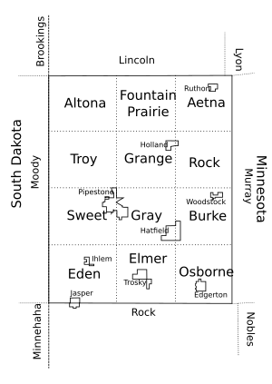
Pipestone County has several cities and smaller communities.
Cities in Pipestone County
These are the main cities located in Pipestone County:
Smaller Communities (Unincorporated)
These are smaller places that are not officially cities or towns:
Townships
A township is a small area of land with its own local government. Here are the townships in Pipestone County:
- Aetna Township
- Altona Township
- Burke Township
- Eden Township
- Elmer Township
- Fountain Prairie Township
- Grange Township
- Gray Township
- Osborne Township
- Rock Township
- Sweet Township
- Troy Township
See also
 In Spanish: Condado de Pipestone para niños
 | George Robert Carruthers |
 | Patricia Bath |
 | Jan Ernst Matzeliger |
 | Alexander Miles |


