Moody County, South Dakota facts for kids
Quick facts for kids
Moody County
|
|
|---|---|

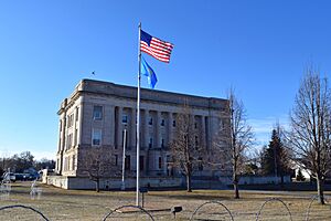
The Moody County Courthouse in Flandreau
|
|

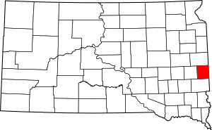
Location within the U.S. state of South Dakota
|
|
 South Dakota's location within the U.S. |
|
| Country | |
| State | |
| Founded | 1873 |
| Named for | Gideon C. Moody |
| Seat | Flandreau |
| Largest city | Flandreau |
| Area | |
| • Total | 521 sq mi (1,350 km2) |
| • Land | 519 sq mi (1,340 km2) |
| • Water | 1.4 sq mi (4 km2) 0.3% |
| Population
(2020)
|
|
| • Total | 6,336 |
| • Estimate
(2023)
|
6,450 |
| • Density | 12.161/sq mi (4.695/km2) |
| Time zone | UTC−6 (Central) |
| • Summer (DST) | UTC−5 (CDT) |
| Congressional district | At-large |
Moody County is a special area called a county in the state of South Dakota, United States. In 2020, about 6,336 people lived here. The main town and government center is Flandreau. The county got its name from Gideon C. Moody.
Contents
Where is Moody County?
Moody County is located on the eastern side of South Dakota. Its eastern border touches the state of Minnesota. The Big Sioux River flows south right through the middle of the county.
The land here has gentle, rolling hills. Most of the land is used for farming. There are also several lakes, especially in the western part of the county. The highest point in the county is about 1,749 feet (533 meters) above sea level.
Main Roads
Many important roads help people travel through Moody County.
Neighboring Counties
Moody County shares its borders with several other counties:
- Brookings County - to the north
- Lincoln County, Minnesota - to the northeast
- Pipestone County, Minnesota - to the east
- Rock County, Minnesota - to the southeast
- Minaha County - to the south
- Lake County - to the west
Lakes in the County
You can find several lakes and water bodies in Moody County:
- Anderson Slough
- Lake Campbell (part of it)
- Mud Lake
- Poison Lake
- Bull Slough
Protected Natural Areas
Moody County also has special areas set aside to protect nature and wildlife. These are called State Game Production Areas:
- Anderson Slough State Game Production Area
- Boles Slough State Game Production Area
- Gideon State Game Production Area
- Hazels Haven State Game Production Area
- Kamp State Game Production Area
- Olson Lake State Game Production Area
People of Moody County
The number of people living in Moody County has changed over the years. Here's how the population has grown and changed:
| Historical population | |||
|---|---|---|---|
| Census | Pop. | %± | |
| 1880 | 3,915 | — | |
| 1890 | 5,941 | 51.7% | |
| 1900 | 8,326 | 40.1% | |
| 1910 | 8,695 | 4.4% | |
| 1920 | 9,742 | 12.0% | |
| 1930 | 9,603 | −1.4% | |
| 1940 | 9,341 | −2.7% | |
| 1950 | 9,252 | −1.0% | |
| 1960 | 8,810 | −4.8% | |
| 1970 | 7,622 | −13.5% | |
| 1980 | 6,692 | −12.2% | |
| 1990 | 6,507 | −2.8% | |
| 2000 | 6,595 | 1.4% | |
| 2010 | 6,486 | −1.7% | |
| 2020 | 6,336 | −2.3% | |
| 2023 (est.) | 6,450 | −0.6% | |
| U.S. Decennial Census 1790-1960 1900-1990 1990-2000 2010-2020 |
|||
Recent Population Data
In 2020, the census counted 6,336 people living in Moody County. There were 2,474 households, which are groups of people living together.
Back in 2010, there were 6,486 people. Most people in the county were white (81.0%). About 14.0% of the population was American Indian. Many families had children under 18 living with them. The average age of people in the county was about 40.5 years old.
Towns and Cities
Moody County has several communities where people live and work.
Cities
Towns
Special Communities
- Pleasant Valley Colony is a census-designated place. This means it's a community identified by the census, but it's not officially a city or town.
Other Communities
- Lone Tree is a small, unincorporated community. This means it's not part of any city or town government.
Townships
Townships are smaller areas within the county that help manage local services.
- Alliance
- Blinsmon
- Clare
- Colman
- Egan
- Enterprise
- Flandreau
- Fremont
- Grovena
- Jefferson
- Lone Rock
- Lynn
- Riverview
- Spring Creek
- Union
- Ward
See also
 In Spanish: Condado de Moody para niños
 | Aurelia Browder |
 | Nannie Helen Burroughs |
 | Michelle Alexander |

