Lincoln County, Minnesota facts for kids
Quick facts for kids
Lincoln County
|
|
|---|---|

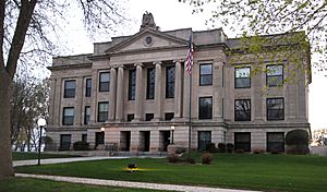
Lincoln County Courthouse
|
|

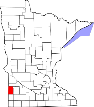
Location within the U.S. state of Minnesota
|
|
 Minnesota's location within the U.S. |
|
| Country | |
| State | |
| Founded | March 6, 1873 |
| Named for | Abraham Lincoln |
| Seat | Ivanhoe |
| Largest city | Tyler |
| Area | |
| • Total | 548 sq mi (1,420 km2) |
| • Land | 537 sq mi (1,390 km2) |
| • Water | 12 sq mi (30 km2) 2.1%% |
| Population
(2020)
|
|
| • Total | 5,640 |
| • Estimate
(2023)
|
5,521 |
| • Density | 10.292/sq mi (3.974/km2) |
| Time zone | UTC−6 (Central) |
| • Summer (DST) | UTC−5 (CDT) |
| Congressional district | 7th |
Lincoln County is a county located in the state of Minnesota in the United States. In 2020, about 5,640 people lived here. The main town, or county seat, where the county government is located, is Ivanhoe.
Contents
History of Lincoln County
How Lincoln County Got Its Name
After the American Civil War, lawmakers in Minnesota wanted to name a county after President Abraham Lincoln. They tried several times to make this happen, in 1861, 1866, and 1870. But each time, the idea either failed to get enough votes or the people in the county didn't agree with it.
When Lincoln County Was Formed
Finally, on March 6, 1873, a new law was passed. This law split Lyon County into two parts. The western half was then named Lincoln County. The people living in the county voted to approve this change in November 1873. On December 5, 1873, Governor Horace Austin officially announced that Lincoln County now existed. At first, the county seat was in a town called Lake Benton.
Moving the County Seat to Ivanhoe
In 1900, a new town was planned closer to the center of Lincoln County. In 1902, the county seat was moved to this new settlement, which is now Ivanhoe.
Geography of Lincoln County
Lincoln County is located right on Minnesota's border with South Dakota. The land here has rolling hills and is mostly used for farming. The Lac qui Parle River flows through the upper eastern part of the county, heading towards the Minnesota River. The highest point in the county is about 1,991 feet (607 meters) above sea level, located on its lower western border. Lincoln County covers about 548 square miles (1,419 square kilometers). Most of this area, about 537 square miles (1,391 square kilometers), is land, and 12 square miles (31 square kilometers) is water.
Lakes in Lincoln County
Lincoln County has many beautiful lakes, including:
- Ash Lake
- Curtis Lake
- Dead Coon Lake
- Drietz Lake
- Gislason Lake
- Hawks Nest Lake
- Lake Benton
- Lake Hendricks (part)
- Lake Shaokatan
- Lake Stay
- Oak Lake
- Perch Lake
- Steep Bank Lake
- Twin Lakes
- West Lake Stay
Major Roads and Highways
Several important highways pass through Lincoln County, connecting its communities:
 U.S. Highway 14
 U.S. Highway 75
 Minnesota State Highway 19
 Minnesota State Highway 23
 Minnesota State Highway 68
 Minnesota State Highway 271
Neighboring Counties
Lincoln County shares its borders with several other counties:
- Deuel County, South Dakota - northwest
- Yellow Medicine County - north
- Lyon County - east
- Pipestone County - south
- Moody County, South Dakota - southwest
- Brookings County, South Dakota - west
Protected Natural Areas
Lincoln County is home to several protected areas, many of which are State Wildlife Management Areas (WMAs). These areas help protect local wildlife and their habitats:
- Altona State Wildlife Management Area (part)
- Ash Lake State Wildlife Management Area
- Blue Wing State Wildlife Management Area
- Bohemian State Wildlife Management Area (part)
- Chen-Bay State Wildlife Management Area
- Christine State Wildlife Management Area
- Collinson State Wildlife Management Area
- Dorer State Wildlife Management Area
- Emerald State Wildlife Management Area
- Expectation State Wildlife Management Area
- Hendricks State Wildlife Management Area
- Hole in the Mountain County Park
- Hope State Wildlife Management Area (part)
- Iron Horse State Wildlife Management Area
- Ivanhoe State Wildlife Management Area
- Johnson State Wildlife Management Area
- Kvermo State Wildlife Management Area
- Minn-Kota State Wildlife Management Area
- Northern Tallgrass Prairie National Wildlife Refuge
- Platyrhynchos State Wildlife Management Area
- Poposki State Wildlife Management Area
- Prairie Dell State Wildlife Management Area
- Shaokatan State Wildlife Management Area
- Sioux Lookout State Wildlife Management Area
- Sokota State Wildlife Management Area (part)
- Suhr State Wildlife Management Area
- Two Sloughs State Wildlife Management Area
Population of Lincoln County
The number of people living in Lincoln County has changed over the years. Here's how the population has grown and shrunk since 1880:
| Historical population | |||
|---|---|---|---|
| Census | Pop. | %± | |
| 1880 | 2,945 | — | |
| 1890 | 5,691 | 93.2% | |
| 1900 | 8,966 | 57.5% | |
| 1910 | 9,874 | 10.1% | |
| 1920 | 11,268 | 14.1% | |
| 1930 | 11,303 | 0.3% | |
| 1940 | 10,797 | −4.5% | |
| 1950 | 10,150 | −6.0% | |
| 1960 | 9,651 | −4.9% | |
| 1970 | 8,143 | −15.6% | |
| 1980 | 8,207 | 0.8% | |
| 1990 | 6,890 | −16.0% | |
| 2000 | 6,429 | −6.7% | |
| 2010 | 5,896 | −8.3% | |
| 2020 | 5,640 | −4.3% | |
| 2023 (est.) | 5,521 | −6.4% | |
| U.S. Decennial Census 1790-1960 1900-1990 1990-2000 2010-2020 |
|||
According to the 2020 census, the population was 5,640 people. Most of the people living in Lincoln County are White.
Communities in Lincoln County
Lincoln County has several towns and smaller communities:
Cities
- Arco
- Hendricks
- Ivanhoe (This is the county seat)
- Lake Benton
- Tyler
Unincorporated Communities
These are smaller communities that are not officially organized as cities:
Townships
Townships are local government areas that cover rural parts of the county:
- Alta Vista Township
- Ash Lake Township
- Diamond Lake Township
- Drammen Township
- Hansonville Township
- Hendricks Township
- Hope Township
- Lake Benton Township
- Lake Stay Township
- Limestone Township
- Marble Township
- Marshfield Township
- Royal Township
- Shaokatan Township
- Verdi Township
See also
 In Spanish: Condado de Lincoln (Minnesota) para niños
 | Anna J. Cooper |
 | Mary McLeod Bethune |
 | Lillie Mae Bradford |

