Lac qui Parle River facts for kids
Quick facts for kids Lac qui Parle River |
|
|---|---|

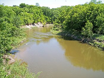
The Lac qui Parle River in Lac qui Parle Township in 2007
|
|
 |
|
| Country | United States |
| State | Minnesota |
| Physical characteristics | |
| Main source | Lake Hendricks Hendricks, Lincoln County 1,755 ft (535 m) 44°30′17″N 96°26′06″W / 44.50472°N 96.43500°W |
| River mouth | Minnesota River Lac qui Parle State Park, Lac qui Parle County 934 ft (285 m) 45°01′35″N 95°52′49″W / 45.02639°N 95.88028°W |
| Length | 118.3 mi (190.4 km) |
| Basin features | |
| Basin size | 1,156 sq mi (2,990 km2) |
| Tributaries |
|
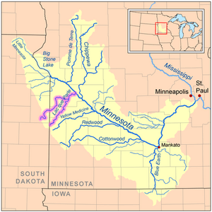
The Lac qui Parle River is a river in southwestern Minnesota, United States. It is about 118 miles (190 km) long. The river flows into the Minnesota River.
Some of its smaller rivers, called tributaries, also flow through eastern South Dakota. The biggest tributary is the West Branch Lac qui Parle River. The Lac qui Parle River is part of the watershed of the Mississippi River. This means its water eventually flows into the Mississippi River. The river drains an area of about 1,156 square miles (2,994 km²). Most of this area is farmland.
The name Lac qui parle comes from the French language. It means "the lake which speaks." This was a French translation of the Sioux name for Lac qui Parle, a lake on the Minnesota River.
Contents
River's Journey
The Lac qui Parle River starts at Lake Hendricks. This lake is on the border of Lincoln County, Minnesota, and Brookings County, South Dakota. The river begins in Hendricks, Minnesota.
It first flows northeast as a stream that sometimes dries up. This part is on the Coteau des Prairies. This is a high, hilly area that divides the Mississippi and Missouri River watersheds. The river then drops about 250 feet (76 m) in eight miles (13 km).
The river continues northeast through flat plains. You can see willow trees and cottonwood trees along its banks. It flows into Lac qui Parle County. It passes east of Dawson.
The river then flows into the Minnesota River. This happens just below Lac qui Parle Lake in Lac qui Parle State Park. This spot is about ten miles (15 km) northwest of Montevideo. In this area, the river flows through a wooded valley. It drops 210 feet (64 m) in 18 miles (29 km). Lac qui Parle Lake was formed by dirt and sand carried by the Lac qui Parle River. A dam helps to keep the lake at its level.
River Branches and Creeks
The biggest branch of the Lac qui Parle River is the West Branch Lac qui Parle River. It is about 64 miles (103.2 km) long. This branch starts in eastern Deuel County, South Dakota. It flows northeast, then east through Lac qui Parle County, past Dawson.
Other smaller streams flow into the river. These include two small trout streams:
- Canby Creek: This creek is 24 miles (39 km) long. It flows northeast through Canby.
- Tenmile Creek: This creek is 33 miles (53 km) long. It flows east and north through Lac qui Parle County, past Boyd.
Land Use Around the River
The Minnesota Pollution Control Agency studies the land around the river. They found that about 79% of the land in Minnesota's part of the watershed is used for farming. Farmers mainly grow corn and soybeans here.
How Fast the River Flows
The United States Geological Survey measures how much water flows in the river. They have a station near the community of Lac qui Parle. Between 1910 and 2005, the river's average flow was 157 cubic feet per second (4 m³/s).
The fastest flow ever recorded was on April 10, 1969. On that day, the river flowed at 17,100 cubic feet per second (484 m³/s). There were also many days in some years when no water was flowing at all.
See also
 In Spanish: Río Lac qui Parle para niños
 | Isaac Myers |
 | D. Hamilton Jackson |
 | A. Philip Randolph |


