Deuel County, South Dakota facts for kids
Quick facts for kids
Deuel County
|
|
|---|---|

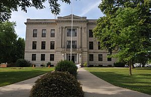
Deuel County Courthouse
|
|

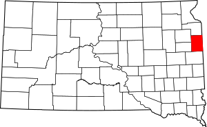
Location within the U.S. state of South Dakota
|
|
 South Dakota's location within the U.S. |
|
| Country | |
| State | |
| Founded | 1862 (created) 1878 (organized) |
| Named for | Jacob Deuel |
| Seat | Clear Lake |
| Largest city | Clear Lake |
| Area | |
| • Total | 637 sq mi (1,650 km2) |
| • Land | 623 sq mi (1,610 km2) |
| • Water | 14 sq mi (40 km2) 2.2% |
| Population
(2020)
|
|
| • Total | 4,295 |
| • Estimate
(2023)
|
4,354 |
| • Density | 6.743/sq mi (2.6033/km2) |
| Time zone | UTC−6 (Central) |
| • Summer (DST) | UTC−5 (CDT) |
| Congressional district | At-large |
Deuel County (pronounced like "DOOL") is a county in the state of South Dakota. A county is like a smaller area within a state, often with its own local government.
In 2020, about 4,295 people lived here. The main town, or county seat, is Clear Lake. Deuel County was first created in 1862 and officially started operating in 1878. It was named after Jacob Deuel, who was a lawmaker in 1862.
Contents
Geography
Deuel County is located on the eastern side of South Dakota. Its eastern border touches the state of Minnesota. The land here has gentle, rolling hills that slope towards the northeast. Most of the land is used for farming.
The highest point in the county is on its western border. It is about 1,936 feet (590 meters) above sea level. The county covers a total area of 637 square miles. Most of this (623 square miles) is land, and 14 square miles (about 2.2%) is water.
Major roads
Neighboring counties
- Grant County - to the north
- Lac qui Parle County, Minnesota - to the northeast
- Yellow Medicine County, Minnesota - to the east
- Lincoln County, Minnesota - to the southeast
- Brookings County - to the south
- Hamlin County - to the southwest
- Codington County - to the northwest
Lakes
- Bullhead Lake
- Briggs Lake
- Clear Lake
- East Coteau Lake
- Fish Lake
- Fox Lake
- Lake Alice
- Lake Cochrane
- Lake Francis
- Lake Ketchum
- Lake Oliver
- Lake Milk
- Lone Tree Lake
- North Coteau Lake
- Round Lake
- Rush Lake
- Salt Lake (part)
- School Lake
- Slough Up’Nort
- South Coteau Lake
- Wigdale Lake
Protected natural areas
- Altamont State Public Shooting Area
- Astoria State Wildlife Management Area
- Briggs Lake State Public Shooting Area
- Crystal Springs State Public Shooting Area
- Lake Cochrane State Recreation Area
- Lake Francis State Public Shooting Area
- Lone Tree Lake State Public Shooting Area
- Mitchell State Public Shooting Area
- Mud Lake State Public Shooting Area
- Nelson State Wildlife Management Area
- Rome State Wildlife Management Area
- Round Lake State Wildlife Management Area
- Runge State Wildlife Management Area
- Rush Lake State Public Shooting Area
- Sharp State Public Shooting Area
- Singsaas Slough State Wildlife Management Area
- Sokota State Wildlife Management Area (partial)
People living in Deuel County
| Historical population | |||
|---|---|---|---|
| Census | Pop. | %± | |
| 1870 | 37 | — | |
| 1880 | 2,302 | 6,121.6% | |
| 1890 | 4,574 | 98.7% | |
| 1900 | 6,656 | 45.5% | |
| 1910 | 7,768 | 16.7% | |
| 1920 | 8,759 | 12.8% | |
| 1930 | 8,732 | −0.3% | |
| 1940 | 8,450 | −3.2% | |
| 1950 | 7,689 | −9.0% | |
| 1960 | 6,782 | −11.8% | |
| 1970 | 5,686 | −16.2% | |
| 1980 | 5,289 | −7.0% | |
| 1990 | 4,522 | −14.5% | |
| 2000 | 4,498 | −0.5% | |
| 2010 | 4,364 | −3.0% | |
| 2020 | 4,295 | −1.6% | |
| 2023 (est.) | 4,354 | −0.2% | |
| U.S. Decennial Census 1790-1960 1900-1990 1990-2000 2010-2020 |
|||
What the 2020 census showed
In 2020, there were 4,295 people living in Deuel County. There were 1,786 households (groups of people living together) and 1,177 families. The population density was about 6.9 people for every square mile. There were also 2,132 housing units (homes or apartments).
What the 2010 census showed
Back in 2010, there were 4,364 people in the county. About 7 people lived in each square mile. Most people (97.5%) were white. Smaller groups included American Indian, Black, and Asian people. About 2% of the population was of Hispanic or Latino background.
Many people in Deuel County have German (50.4%) or Norwegian (25.4%) family backgrounds. Other backgrounds include Irish, Dutch, and English.
About 28.2% of households had children under 18 living there. Most households (58.6%) were married couples. The average age of people in the county was 43.9 years old.
The average income for a household was $47,000 per year. For families, it was $55,439. About 6.1% of all people in the county lived below the poverty line. This means they had a very low income.
Towns and communities
Deuel County has several towns and smaller communities.
Cities
- Clear Lake (This is the county seat, where the main government offices are)
- Gary
Towns
Smaller communities (unincorporated)
These are places that don't have their own local government like cities or towns.
Townships
Townships are smaller areas within a county, often used for local administration.
- Altamont
- Antelope Valley
- Blom, Brandt
- Clear Lake
- Glenwood
- Goodwin
- Grange
- Havana
- Herrick
- Hidewood
- Lowe
- Norden
- Portland
- Rome
- Scandinavia
See also
 In Spanish: Condado de Deuel (Dakota del Sur) para niños
 | John T. Biggers |
 | Thomas Blackshear |
 | Mark Bradford |
 | Beverly Buchanan |

