
Yellow Medicine County, Minnesota facts for kids
Quick facts for kids
Yellow Medicine County
|
|
|---|---|

Yellow Medicine County Courthouse in Granite Falls in 2007
|
|

Location within the U.S. state of Minnesota
|
|
 Minnesota's location within the U.S. |
|
| Country | |
| State | |
| Founded | March 6, 1871 |
| Named for | Yellow Medicine River |
| Seat | Granite Falls |
| Largest city | Granite Falls |
| Area | |
| • Total | 763 sq mi (1,980 km2) |
| • Land | 759 sq mi (1,970 km2) |
| • Water | 4.1 sq mi (11 km2) 0.5%% |
| Population
(2020)
|
|
| • Total | 9,528 |
| • Estimate
(2023)
|
9,467 |
| • Density | 12.6/sq mi (4.9/km2) |
| Time zone | UTC−6 (Central) |
| • Summer (DST) | UTC−5 (CDT) |
| Congressional district | 7th |
Yellow Medicine County is a county located in the southwestern part of Minnesota, a state in the United States. The Minnesota River forms its eastern border. In 2020, about 9,528 people lived here. The main town and county seat is Granite Falls.
The Upper Sioux Indian Reservation is completely inside Yellow Medicine County. This reservation is connected to the historical Yellow Medicine Agency, which was once in this area. It was created in 1851 by the Treaty of Traverse des Sioux. Through this treaty, the Dakota people gave up a lot of their land in the region to the United States.
Contents
History of Yellow Medicine County
The state of Minnesota officially created Yellow Medicine County on March 6, 1871. Granite Falls was chosen as its county seat. The county gets its name from the Yellow Medicine River, which flows through the eastern part of the county and into the Minnesota River. The river itself was named after a plant called Menispermum canadense, also known as the moonseed plant. Its yellow roots were used by the native Dakota people for medicine.
In 1878, there was a plan to create a new county called Canby County. This new county would have been made from parts of Yellow Medicine, Lincoln, and Lac qui Parle counties. The state government approved this idea, and Governor Pillsbury signed the plan on February 27, 1879. However, the people living in the three counties did not vote for it, so Canby County was never formed.
Geography of Yellow Medicine County
Yellow Medicine County is located on the western side of Minnesota. Its western border touches the state of South Dakota. The Minnesota River flows east-southeast along the county's northeast side. It eventually flows into the Mississippi River. The Yellow Medicine River flows northeast through the eastern part of the county. It joins the Minnesota River near the middle of the county's eastern border.
Other smaller rivers and creeks also flow through the county. These include Stony Run Creek, Florida Creek, and the Lac qui Parle River. The land in the county has rolling hills, which have been shaped by these waterways. Most of the land is used for farming. The highest point in the county is on its western border, reaching about 1,732 feet (528 meters) above sea level. Yellow Medicine County covers about 763 square miles (1,976 square kilometers). Of this, 759 square miles (1,966 square kilometers) is land, and 4.1 square miles (11 square kilometers) is water.
Lakes in the County
- Burton Lake
- Culver Lake (part)
- Curtis Lake
- Highbank Lake
- Kvistid Lake
- Lake Louie
- Lone Tree Lake
- Miedd Lake
- Miller Lake
- Mud Lake
- Spellman Lake
- Timm Lake
- Tyson Lake
- Wood Lake
Rivers and Creeks
- Florida Creek
- Lac qui Parle River
- Minnesota River
- Spring Creek
- Stony Run Creek
- Yellow Medicine River
Main Roads and Highways
- U.S. Highway 59
- U.S. Highway 75
- U.S. Highway 212
- Minnesota State Highway 23
- Minnesota State Highway 67
- Minnesota State Highway 68
- Minnesota State Highway 167
- Minnesota State Highway 274 (this road was removed in 2022)
Neighboring Counties
- Lac qui Parle County - north
- Chippewa County - northeast
- Renville County - east
- Redwood County - southeast
- Lyon County - south
- Lincoln County - southwest
- Deuel County, South Dakota - west
Protected Natural Areas
- Bigrock State Wildlife Management Area
- Christopherson State Wildlife Management Area
- Clawson State Wildlife Management Area
- Flinks State Wildlife Management Area
- Miller-Richter State Wildlife Management Area
- Mound Springs Prairie Scientific and Natural Area
- Omro State Wildlife Management Area
- Oshkosh State Wildlife Management Area
- Penthole State Wildlife Management Area
- Posen State Wildlife Management Area
- Saint Leo State Wildlife Management Area
- Sioux Nation State Wildlife Management Area
- Stokke State Wildlife Management Area
- Stony Run State Wildlife Management Area
- Swedes Forest Scientific and Natural Area (part)
- Upper Sioux Agency State Park
Population and People
| Historical population | |||
|---|---|---|---|
| Census | Pop. | %± | |
| 1880 | 5,884 | — | |
| 1890 | 9,854 | 67.5% | |
| 1900 | 14,602 | 48.2% | |
| 1910 | 15,406 | 5.5% | |
| 1920 | 16,550 | 7.4% | |
| 1930 | 16,625 | 0.5% | |
| 1940 | 16,917 | 1.8% | |
| 1950 | 16,279 | −3.8% | |
| 1960 | 15,523 | −4.6% | |
| 1970 | 14,418 | −7.1% | |
| 1980 | 13,653 | −5.3% | |
| 1990 | 11,684 | −14.4% | |
| 2000 | 11,080 | −5.2% | |
| 2010 | 10,438 | −5.8% | |
| 2020 | 9,528 | −8.7% | |
| 2023 (est.) | 9,467 | −9.3% | |
| U.S. Decennial Census 1790-1960 1900-1990 1990-2000 2010-2020 |
|||
Population in 2020
In 2020, the United States Census collected information about the people living in Yellow Medicine County. Here's a breakdown of the different groups:
| Group | Number of People | Percentage of Total |
|---|---|---|
| White | 8,408 | 88.3% |
| Black or African American | 48 | 0.5% |
| Native American | 276 | 3% |
| Asian | 28 | 0.3% |
| Pacific Islander | 1 | 0.01% |
| Other/Mixed Race | 319 | 3.4% |
| Hispanic or Latino | 448 | 4.7% |
Towns and Communities
Cities in Yellow Medicine County
- Canby
- Clarkfield
- Echo
- Granite Falls (This is the county seat, and part of it is in Chippewa County)
- Hanley Falls
- Hazel Run
- Porter
- St. Leo
- Wood Lake
Small Unincorporated Communities
These are smaller places that are not officially organized as cities or towns.
- Burr (originally named Stanley)
- Lorne
- Normania
- Spring Creek
Townships in the County
Townships are smaller local government areas within the county.
- Burton Township
- Echo Township
- Florida Township
- Fortier Township
- Friendship Township
- Hammer Township
- Hazel Run Township
- Lisbon Township
- Minnesota Falls Township
- Norman Township
- Normania Township
- Omro Township
- Oshkosh Township
- Posen Township
- Sandnes Township
- Sioux Agency Township
- Stony Run Township
- Swede Prairie Township
- Tyro Township
- Wergeland Township
- Wood Lake Township
Images for kids
-
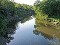
The Yellow Medicine River, which gives the county its name.
-

U.S. Highway 59 sign.
-
U.S. Highway 75 sign.
-

U.S. Highway 212 sign in Minnesota.
-
Minnesota State Highway 23 sign.
-
Minnesota State Highway 67 sign.
-
Minnesota State Highway 68 sign.
-
Minnesota State Highway 167 sign.
-
Minnesota State Highway 274 sign (now decommissioned).
-

A friendly robot icon.


.svg)


See also
 In Spanish: Condado de Yellow Medicine para niños
