Yellow Medicine River facts for kids
Quick facts for kids Yellow Medicine River |
|
|---|---|

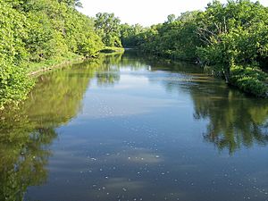
The Yellow Medicine River in Minnesota Falls Township in 2007
|
|
 |
|
| Country | United States |
| State | Minnesota |
| Physical characteristics | |
| Main source | Lake Shaokatan Shaokatan Township, Lincoln County 1,776 ft (541 m) 44°24′41″N 96°21′05″W / 44.41139°N 96.35139°W |
| River mouth | Minnesota River Upper Sioux Agency State Park, Yellow Medicine County 869 ft (265 m) 44°44′21″N 95°25′43″W / 44.73917°N 95.42861°W |
| Length | 107.2 mi (172.5 km) |
| Basin features | |
| Basin size | 665 sq mi (1,720 km2) |
| Tributaries |
|
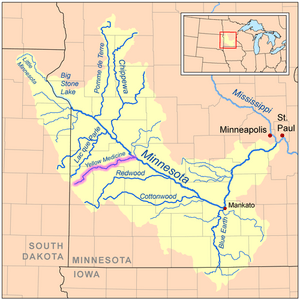
The Yellow Medicine River is a river in southwestern Minnesota, United States. It is about 107 miles (173 km) long. This river flows into the Minnesota River, which then flows into the Mississippi River. This means the Yellow Medicine River is part of the huge watershed of the Mississippi River.
The river's name comes from the Dakota people. They called it pajutazee. This name means "yellow medicine root" or "they dig yellow roots." This likely refers to a plant with yellow roots found near the river.
Contents
Where Does the Yellow Medicine River Start?
The Yellow Medicine River begins at Lake Shaokatan in Lincoln County. This area is on a high, hilly plain called the Coteau des Prairies. This plain separates the water that flows to the Mississippi River from water that flows to the Missouri River.
The river starts as a small stream, sometimes drying up, near Ivanhoe. It then flows off the Coteau, dropping about 250 feet (75 m) in a short distance.
What Path Does the River Follow?
After leaving the Coteau, the Yellow Medicine River turns to flow east-northeast. It travels through flat, open lands in Lyon County and Yellow Medicine County. You won't see many trees along this part of the river. It flows past towns like Hanley Falls.
The river finally joins the Minnesota River inside Upper Sioux Agency State Park. This is near Granite Falls. In its last 10 miles (15 km), the river drops another 85 feet (30 m) as it flows into the Minnesota River valley.
What Are the Main Branches of the River?
The Yellow Medicine River has two main branches:
- North Branch Yellow Medicine River: This branch is about 41 miles (66 km) long. It flows through northern Lincoln County and briefly enters Yellow Medicine County, passing near Porter.
- South Branch Yellow Medicine River: This branch is longer, about 62 miles (99 km) long. It flows through Lincoln County and into northwestern Lyon County, going past Minneota.
Other smaller streams also feed into the Yellow Medicine River. These include Spring Creek, which is 46 miles (74 km) long, and Mud Creek, which is 31 miles (50 km) long.
How Is the Land Around the River Used?
The land around the Yellow Medicine River is mostly used for farming. About 81% of the land in this area is farmland. The main crops grown here are corn and soybeans. This farming activity can affect the river's water quality.
What Fish Live in the Yellow Medicine River?
Many types of fish make their home in the Yellow Medicine River. Some common fish you might find include:
How Much Water Flows in the River?
Scientists measure how much water flows in the Yellow Medicine River near Granite Falls. Between 1931 and 2005, the river's average flow was 142 cubic feet per second (4 m³/s).
The most water ever recorded flowing in the river was on April 10, 1969. On that day, 17,200 cubic feet per second (487 m³/s) of water rushed by! However, sometimes the river has very little water, and it has even been recorded as having zero flow on some days.
 | Percy Lavon Julian |
 | Katherine Johnson |
 | George Washington Carver |
 | Annie Easley |


