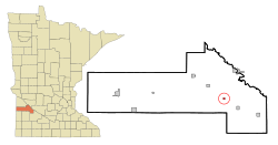
Hanley Falls, Minnesota facts for kids
Quick facts for kids
Hanley Falls
|
|
|---|---|

Location of Hanley Falls, Minnesota
|
|
| Country | United States |
| State | Minnesota |
| County | Yellow Medicine |
| Area | |
| • Total | 0.25 sq mi (0.65 km2) |
| • Land | 0.25 sq mi (0.65 km2) |
| • Water | 0.00 sq mi (0.00 km2) |
| Elevation | 1,050 ft (320 m) |
| Population
(2020)
|
|
| • Total | 243 |
| • Density | 975.90/sq mi (376.27/km2) |
| Time zone | UTC-6 (Central (CST)) |
| • Summer (DST) | UTC-5 (CDT) |
| ZIP code |
56245
|
| Area code(s) | 507 |
| FIPS code | 27-26972 |
| GNIS feature ID | 2394285 |
Hanley Falls is a small city located in Yellow Medicine County, Minnesota, in the United States. In 2020, about 243 people lived there.
Contents
History of Hanley Falls
Hanley Falls started in 1884. It was created when a railroad line, the Minneapolis and St. Louis Railway, reached that spot. The city was named after a person who worked for the railroad.
A post office opened in Hanley Falls in 1887. The city officially became an incorporated city in 1892.
Geography and Location
Hanley Falls covers a total area of about 0.65 square kilometers (0.25 square miles). All of this area is land.
The Yellow Medicine River flows right through the city. This river is an important natural feature.
Minnesota State Highway 23 is a main road that goes through Hanley Falls. It helps people travel to and from the community.
Railroad Intersection History
Two railroad lines cross paths on the northwest side of Hanley Falls. In 1900, there was a big legal case about these railroads. The U.S. Supreme Court decided that the state of Minnesota could make the railroads build a special connection track. This track, called the "Hanley Falls Wye," was for the public's convenience, even if the railroad companies didn't want to build it.
Population and People
| Historical population | |||
|---|---|---|---|
| Census | Pop. | %± | |
| 1900 | 278 | — | |
| 1910 | 275 | −1.1% | |
| 1920 | 326 | 18.5% | |
| 1930 | 288 | −11.7% | |
| 1940 | 336 | 16.7% | |
| 1950 | 320 | −4.8% | |
| 1960 | 334 | 4.4% | |
| 1970 | 265 | −20.7% | |
| 1980 | 265 | 0.0% | |
| 1990 | 246 | −7.2% | |
| 2000 | 323 | 31.3% | |
| 2010 | 304 | −5.9% | |
| 2020 | 243 | −20.1% | |
| U.S. Decennial Census | |||
2010 Population Details
According to the 2010 census, 304 people lived in Hanley Falls. There were 107 households and 74 families.
Many households, about 45.8%, had children under 18 living with them. Most households, 55.1%, were married couples living together.
The average age of people in the city was 27.4 years old. About 36.5% of the residents were under 18. Also, 7.6% of the people were 65 years old or older.
Arts and Culture
Hanley Falls is home to the Minnesota's Machinery Museum (MMM). This museum has five large buildings on a six-acre site. It holds the state's biggest collection of farming equipment and exhibits.
The museum shares stories and items from a century of farm life. It is open from May to September, seven days a week.
See also
 In Spanish: Hanley Falls (Minnesota) para niños
 | Georgia Louise Harris Brown |
 | Julian Abele |
 | Norma Merrick Sklarek |
 | William Sidney Pittman |

