Chippewa County, Minnesota facts for kids
Quick facts for kids
Chippewa County
|
|
|---|---|

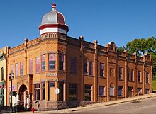
Chippewa County Bank in Montevideo.
|
|

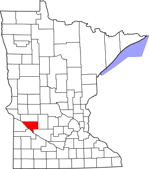
Location within the U.S. state of Minnesota
|
|
 Minnesota's location within the U.S. |
|
| Country | |
| State | |
| Founded | February 20, 1862 (created) 1868 (organized) |
| Named for | Chippewa River |
| Seat | Montevideo |
| Largest city | Montevideo |
| Area | |
| • Total | 588 sq mi (1,520 km2) |
| • Land | 581 sq mi (1,500 km2) |
| • Water | 6.7 sq mi (17 km2) 1.1%% |
| Population
(2020)
|
|
| • Total | 12,598 |
| • Estimate
(2023)
|
12,172 |
| • Density | 21.7/sq mi (8.4/km2) |
| Time zone | UTC−6 (Central) |
| • Summer (DST) | UTC−5 (CDT) |
| Congressional district | 7th |
Chippewa County (/ˈtʃɪpəˌwɑː/ chip-Ə-wah) is a county in the U.S. state of Minnesota. It's named after the Chippewa River, which flows through the area.
In 2020, about 12,598 people lived here. The main city and place where the county government is located is Montevideo. Chippewa County was officially created in 1862 and started its government in 1868.
Contents
History of Chippewa County
Chippewa County officially started its own government on March 5, 1868. Before that, it was part of Renville County. The county's borders changed a bit in 1870, separating it from Swift County.
The first leaders of the county were three commissioners chosen by the governor. Their names were Daniel S. Wilkins, Ole Thorson, and M. Davidson. They had their very first meeting in Mr. Wilkins's cabin on January 9, 1869.
Choosing the County Seat
The county seat is the city where the main government offices are located. The first village planned in Chippewa County was called Chippewa City. It was on the west side of the Chippewa River. Daniel S. Wilkins, one of the first settlers, planned this town in 1868. His cabin in Chippewa City was where the first county meetings took place.
Another important settler, George W. Frink, arrived in 1867. He built a log house on the east side of the Chippewa River, in a place that would become Montevideo. With towns on both sides of the river, people started to debate which one should be the county seat.
There's a story that some people from Montevideo went to Chippewa City and took the county records. They also moved the post office to Montevideo. The state of Minnesota later made this move official. Because of this, Montevideo is still the county seat of Chippewa County today.
Geography and Nature
Chippewa County is located in western Minnesota. The Minnesota River flows along its southwestern border. The Chippewa River also flows south through the western part of the county. It eventually joins the Minnesota River.
The land in the county has gentle, rolling hills. Most of the land is used for farming. The highest point in the county is about 1,142 feet (348 meters) above sea level. The county covers a total area of 588 square miles. Most of this (581 square miles) is land, and a small part (6.7 square miles) is water.
Lakes in Chippewa County
Chippewa County has several lakes, including:
- Carlton Lake
- Long Lake
- Norboro Lake
- Round Lake
- Shakopee Lake
- Watson Sag
Main Roads and Highways
Several important highways pass through Chippewa County, making it easy to travel around:
 U.S. Highway 59
 U.S. Highway 212
 Minnesota State Highway 7
 Minnesota State Highway 23
 Minnesota State Highway 29
 Minnesota State Highway 40
Neighboring Counties
Chippewa County shares borders with these other counties:
- Swift County (to the north)
- Kandiyohi County (to the northeast)
- Renville County (to the southeast)
- Yellow Medicine County (to the southwest)
- Lac qui Parle County (to the west)
Protected Natural Areas
The county has special areas set aside to protect nature and wildlife:
- Boike State Wildlife Management Area
- Franko State Wildlife Management Area
- Gneiss Outcrops Scientific and Natural Area
- Minnesota River Valley Overlook
- Spartan State Wildlife Management Area
Climate and Weather
| Weather chart for Montevideo, Minnesota | |||||||||||||||||||||||||||||||||||||||||||||||
|---|---|---|---|---|---|---|---|---|---|---|---|---|---|---|---|---|---|---|---|---|---|---|---|---|---|---|---|---|---|---|---|---|---|---|---|---|---|---|---|---|---|---|---|---|---|---|---|
| J | F | M | A | M | J | J | A | S | O | N | D | ||||||||||||||||||||||||||||||||||||
|
0.9
22
2
|
1
27
7
|
1.8
39
19
|
2.5
56
33
|
3
69
46
|
4.2
78
56
|
3.7
83
61
|
3.4
81
58
|
3.3
72
48
|
2.3
59
35
|
1.7
41
21
|
0.9
25
7
|
||||||||||||||||||||||||||||||||||||
| temperatures in °F precipitation totals in inches source: The Weather Channel |
|||||||||||||||||||||||||||||||||||||||||||||||
|
Metric conversion
|
|||||||||||||||||||||||||||||||||||||||||||||||
The weather in Chippewa County changes a lot throughout the year. In the county seat of Montevideo, average temperatures are around 2°F (about -17°C) in January. They can reach up to 83°F (about 28°C) in July.
However, temperatures can be much more extreme. The coldest temperature ever recorded was -37°F (-38°C) in January 1970. The hottest was 110°F (43°C) in July 1988. The county gets the most rain in June, and the least in December.
Population Information
| Historical population | |||
|---|---|---|---|
| Census | Pop. | %± | |
| 1870 | 1,467 | — | |
| 1880 | 5,408 | 268.6% | |
| 1890 | 8,555 | 58.2% | |
| 1900 | 12,499 | 46.1% | |
| 1910 | 13,458 | 7.7% | |
| 1920 | 15,720 | 16.8% | |
| 1930 | 15,762 | 0.3% | |
| 1940 | 16,927 | 7.4% | |
| 1950 | 16,739 | −1.1% | |
| 1960 | 16,320 | −2.5% | |
| 1970 | 15,109 | −7.4% | |
| 1980 | 14,941 | −1.1% | |
| 1990 | 13,228 | −11.5% | |
| 2000 | 13,088 | −1.1% | |
| 2010 | 12,441 | −4.9% | |
| 2020 | 12,598 | 1.3% | |
| 2023 (est.) | 12,172 | −2.2% | |
| U.S. Decennial Census 1790-1960 1900-1990 1990-2000 2010-2020 |
|||
The population of Chippewa County has changed over the years. In 1870, there were only 1,467 people. The population grew steadily and reached its highest point in 1940 with 16,927 people. Since then, the population has slowly decreased.
Who Lives in Chippewa County?
According to the 2020 census, here's a look at the different groups of people living in Chippewa County:
| Group | Number of People | Percentage |
|---|---|---|
| White | 10,473 | 83.13% |
| Black or African American | 75 | 0.6% |
| Native American | 102 | 0.8% |
| Asian | 44 | 0.34% |
| Pacific Islander | 296 | 2.4% |
| Other/Mixed Race | 365 | 2.9% |
| Hispanic or Latino | 1,243 | 9.9% |
This table shows that most people in Chippewa County are White. There are also smaller groups of people from various other backgrounds.
Cities and Towns
Chippewa County has several cities and smaller communities where people live.
Cities in Chippewa County
- Clara City
- Granite Falls (partially in this county)
- Maynard
- Milan
- Montevideo (the county seat)
- Watson
Smaller Communities (Unincorporated)
These are smaller places that are not officially cities:
Townships
Townships are smaller local government areas, often covering rural parts of the county:
- Big Bend Township
- Crate Township
- Grace Township
- Granite Falls Township
- Havelock Township
- Kragero Township
- Leenthrop Township
- Lone Tree Township
- Louriston Township
- Mandt Township
- Rheiderland Township
- Rosewood Township
- Sparta Township
- Stoneham Township
- Tunsberg Township
- Woods Township
See also
 In Spanish: Condado de Chippewa (Minnesota) para niños
 | Bessie Coleman |
 | Spann Watson |
 | Jill E. Brown |
 | Sherman W. White |


