Maynard, Minnesota facts for kids
Quick facts for kids
Maynard
|
|
|---|---|

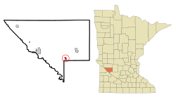
Location of Maynard, Minnesota
|
|
| Country | United States |
| State | Minnesota |
| County | Chippewa |
| Area | |
| • Total | 0.60 sq mi (1.55 km2) |
| • Land | 0.60 sq mi (1.55 km2) |
| • Water | 0.00 sq mi (0.00 km2) |
| Elevation | 1,027 ft (313 m) |
| Population
(2020)
|
|
| • Total | 319 |
| • Density | 532.55/sq mi (205.57/km2) |
| Time zone | UTC-6 (Central (CST)) |
| • Summer (DST) | UTC-5 (CDT) |
| ZIP code |
56260
|
| Area code(s) | 320 |
| FIPS code | 27-41210 |
| GNIS feature ID | 2395052 |
Maynard is a small city located in Chippewa County, Minnesota, in the United States. In 2010, about 366 people lived there. By 2020, the population was 319.
Contents
History of Maynard
Maynard was officially planned and laid out in 1887. It was named after the brother-in-law of an important railroad official. A post office, where people send and receive mail, has been open in Maynard since 1889.
Geography and Location
According to the United States Census Bureau, Maynard covers a total area of about 0.65 square miles (1.55 square kilometers). All of this area is land. There are no large bodies of water within the city limits.
Minnesota State Highway 23 is the main road that runs through Maynard. This highway helps connect the community to other towns and cities nearby.
Population and People of Maynard
| Historical population | |||
|---|---|---|---|
| Census | Pop. | %± | |
| 1900 | 245 | — | |
| 1910 | 386 | 57.6% | |
| 1920 | 536 | 38.9% | |
| 1930 | 504 | −6.0% | |
| 1940 | 580 | 15.1% | |
| 1950 | 507 | −12.6% | |
| 1960 | 429 | −15.4% | |
| 1970 | 455 | 6.1% | |
| 1980 | 428 | −5.9% | |
| 1990 | 419 | −2.1% | |
| 2000 | 388 | −7.4% | |
| 2010 | 366 | −5.7% | |
| 2020 | 319 | −12.8% | |
| U.S. Decennial Census | |||
The population of Maynard has changed over the years. The table above shows how many people have lived in the city during different census years. A census is an official count of the population, usually done every ten years.
What the 2010 Census Showed
In 2010, the census counted 366 people living in Maynard. These people lived in 158 different households, and 99 of these were families. The city had about 563 people per square mile.
Most of the people in Maynard were White (92.6%). A smaller number were African American (1.1%), Native American (0.3%), or Asian (1.1%). About 4.9% of the population identified as being from other races. People who identified as Hispanic or Latino made up 5.5% of the population.
Out of the 158 households, about 27% had children under 18 living with them. More than half (51.9%) were married couples living together. Some households were led by a single parent, either a mother (6.3%) or a father (4.4%). About 37% of households were not families.
The average household in Maynard had 2.32 people. For families, the average size was 2.95 people. About 19% of households had someone living alone who was 65 years old or older.
The average age of people in Maynard in 2010 was 43.3 years. About 23.5% of residents were under 18. About 8.2% were between 18 and 24 years old. People aged 25 to 44 made up 20.5% of the population. The largest group, 31.8%, was between 45 and 64 years old. Finally, 16.1% of the residents were 65 years or older. The city's population was made up of 47.5% males and 52.5% females.
See also
 In Spanish: Maynard (Minnesota) para niños
- Maynard (Minnesota) para niños (This article in Spanish for kids)
 | William L. Dawson |
 | W. E. B. Du Bois |
 | Harry Belafonte |

