Watson, Minnesota facts for kids
Quick facts for kids
Watson
|
|
|---|---|

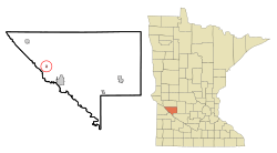
Location of Watson, Minnesota
|
|
| Country | United States |
| State | Minnesota |
| County | Chippewa |
| Area | |
| • Total | 0.17 sq mi (0.45 km2) |
| • Land | 0.17 sq mi (0.45 km2) |
| • Water | 0.00 sq mi (0.00 km2) |
| Elevation | 1,030 ft (310 m) |
| Population
(2020)
|
|
| • Total | 182 |
| • Density | 1,040.00/sq mi (401.47/km2) |
| Time zone | UTC-6 (Central (CST)) |
| • Summer (DST) | UTC-5 (CDT) |
| ZIP code |
56295
|
| Area code(s) | 320 |
| FIPS code | 27-68656 |
| GNIS feature ID | 2397218 |
Watson is a small city in Chippewa County, Minnesota, United States. In 2010, about 205 people lived there. You can find Lac qui Parle State Park nearby, which is a great place to visit.
Contents
History of Watson
Watson was first planned out in 1879. This happened when the railroad lines were built to reach that spot. The city got its name from a local business called the Watson Farmers Elevator. This was a place where farmers stored their grain. A post office has been open in Watson since 1879, helping people send and receive mail.
Geography of Watson
Watson is a small city, covering about 0.18 square miles (0.45 square kilometers) of land. There is no water area within the city limits.
Two important roads, U.S. Route 59 and Minnesota State Highway 7, run through the community. They are signed together, meaning they share the same road for a part of their journey.
Watson is sometimes called "The Goose Capitol of the USA." This is because many Canada geese fly through and stay near Lac Qui Parle every fall. It's a popular spot for these birds during their migration.
Population of Watson
| Historical population | |||
|---|---|---|---|
| Census | Pop. | %± | |
| 1900 | 167 | — | |
| 1910 | 152 | −9.0% | |
| 1920 | 215 | 41.4% | |
| 1930 | 246 | 14.4% | |
| 1940 | 290 | 17.9% | |
| 1950 | 284 | −2.1% | |
| 1960 | 267 | −6.0% | |
| 1970 | 228 | −14.6% | |
| 1980 | 238 | 4.4% | |
| 1990 | 211 | −11.3% | |
| 2000 | 209 | −0.9% | |
| 2010 | 205 | −1.9% | |
| 2020 | 182 | −11.2% | |
| U.S. Decennial Census | |||
Watson's Population in 2010
In 2010, a census (a count of the population) showed that 205 people lived in Watson. There were 90 households and 50 families. The city had about 1139 people per square mile. There were 102 housing units, with about 567 units per square mile.
Most people in Watson were White (98.5%). About 1.0% were from other races, and 0.5% were from two or more races. About 1.5% of the population identified as Hispanic or Latino.
Out of the 90 households, 31.1% had children under 18 living with them. About 43.3% were married couples living together. Some households (5.6%) had a female head without a husband, and 6.7% had a male head without a wife. About 44.4% of households were not families.
Many households (37.8%) had only one person living there. About 12.2% of households had someone aged 65 or older living alone. On average, each household had 2.28 people, and each family had 3.08 people.
The average age in Watson was 41.2 years. About 28.3% of residents were under 18. About 6.9% were between 18 and 24. People aged 25 to 44 made up 21.5% of the population. Those aged 45 to 64 were 30.8%, and 12.7% were 65 or older. More males lived in Watson (56.1%) than females (43.9%).
See also
 In Spanish: Watson (Minnesota) para niños
 | Calvin Brent |
 | Walter T. Bailey |
 | Martha Cassell Thompson |
 | Alberta Jeannette Cassell |

