Gary, South Dakota facts for kids
Quick facts for kids
Gary, South Dakota
|
|
|---|---|
| Motto(s):
"Gate City To The Dakotas"
|
|

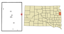
Location in Deuel County and the state of South Dakota
|
|
| Country | United States |
| State | South Dakota |
| County | Deuel |
| Incorporated | 1917 |
| Area | |
| • Total | 0.75 sq mi (1.94 km2) |
| • Land | 0.75 sq mi (1.94 km2) |
| • Water | 0.00 sq mi (0.00 km2) |
| Elevation | 1,437 ft (438 m) |
| Population
(2020)
|
|
| • Total | 240 |
| • Density | 320.86/sq mi (123.89/km2) |
| Time zone | UTC-6 (Central (CST)) |
| • Summer (DST) | UTC-5 (CDT) |
| ZIP code |
57237
|
| Area code(s) | 605 |
| FIPS code | 46-23860 |
| GNIS feature ID | 1267401 |
Gary is a small city in Deuel County, South Dakota, United States. In 2020, about 240 people lived there. A main road, South Dakota Highway 101, goes through the city. In 2022, Gary celebrated its 150th birthday!
Contents
History of Gary, South Dakota
Gary got its name from H. B. Gary, who was a postal official. A post office opened here in 1874. The city was officially planned by the railroad in 1877. For a while, it was also known as "State Line." Gary became an incorporated city in 1917.
Geography and Location
Gary is located in South Dakota. The United States Census Bureau says the city covers about 0.75 square miles (1.94 square kilometers) of land. There is no water area within the city limits. The West Branch of the Lac qui Parle River flows through Gary. This river starts as a spring-fed stream nearby.
Population Changes in Gary
The number of people living in Gary has changed over the years. Here is a look at the population from 1890 to 2020:
| Historical population | |||
|---|---|---|---|
| Census | Pop. | %± | |
| 1890 | 277 | — | |
| 1900 | 345 | 24.5% | |
| 1910 | 477 | 38.3% | |
| 1920 | 588 | 23.3% | |
| 1930 | 543 | −7.7% | |
| 1940 | 566 | 4.2% | |
| 1950 | 558 | −1.4% | |
| 1960 | 471 | −15.6% | |
| 1970 | 366 | −22.3% | |
| 1980 | 354 | −3.3% | |
| 1990 | 274 | −22.6% | |
| 2000 | 231 | −15.7% | |
| 2010 | 227 | −1.7% | |
| 2020 | 240 | 5.7% | |
| U.S. Decennial Census | |||
Gary's Population in 2010
In 2010, the city of Gary had 227 people living in 120 households. About 61 of these households were families. The city had about 329 people per square mile.
Most of the people in Gary were White (96.9%). A small number were African American (0.9%) or Native American (1.8%). Some people were from two or more races (0.4%). About 1.3% of the population was Hispanic or Latino.
Households and Families
Out of the 120 households:
- 17.5% had children under 18 living with them.
- 42.5% were married couples living together.
- 6.7% had a female head of the house with no husband.
- 1.7% had a male head of the house with no wife.
- 49.2% were not families.
Almost half of all households (47.5%) had only one person living there. About 23.3% of households had someone aged 65 or older living alone. On average, each household had 1.89 people, and each family had 2.67 people.
Age Groups in Gary
In 2010, the average age of people in Gary was 51.6 years old.
- 18.1% of residents were under 18 years old.
- 5.3% were between 18 and 24 years old.
- 17.9% were between 25 and 44 years old.
- 32.6% were between 45 and 64 years old.
- 26% were 65 years old or older.
The city had slightly more males (51.5%) than females (48.5%).
See also

- In Spanish: Gary (Dakota del Sur) para niños
 | Frances Mary Albrier |
 | Whitney Young |
 | Muhammad Ali |

