Flandreau, South Dakota facts for kids
Quick facts for kids
Flandreau
|
|
|---|---|

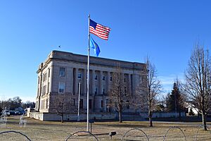
Moody County Courthouse
|
|
| Motto(s):
"The Heart Of South Dakota"
|
|

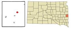
Location in Moody County and the state of South Dakota
|
|
| Country | United States |
| State | South Dakota |
| County | Moody |
| Incorporated | 1902 |
| Area | |
| • Total | 1.93 sq mi (4.99 km2) |
| • Land | 1.86 sq mi (4.81 km2) |
| • Water | 0.07 sq mi (0.17 km2) |
| Elevation | 1,565 ft (477 m) |
| Population
(2020)
|
|
| • Total | 2,372 |
| • Density | 1,275.95/sq mi (492.72/km2) |
| Time zone | UTC−6 (Central (CST)) |
| • Summer (DST) | UTC−5 (CDT) |
| ZIP code |
57028
|
| Area code(s) | 605 |
| FIPS code | 46-21540 |
| GNIS feature ID | 1267391 |
Flandreau (pronounced FLAN-droo) is a city in South Dakota, United States. It is the main city and county seat of Moody County. In 2020, about 2,372 people lived there.
The city was named after Charles Eugene Flandrau. He was a judge in the Minnesota territory. He is remembered for helping to protect the town of New Ulm, Minnesota in 1862.
Contents
Where is Flandreau?
Flandreau is located in South Dakota, right next to the Big Sioux River.
The city covers about 1.93 square miles (4.99 square kilometers). Most of this area is land, with a small part being water.
What's the weather like?
Flandreau has a climate with warm summers and cold winters. The hottest month is usually July, and the coldest is January. It gets a good amount of rain, especially in late spring and summer. Snowfall is common in winter.
| Climate data for Flandreau, South Dakota (1991−2020 normals, extremes 1893−present) | |||||||||||||
|---|---|---|---|---|---|---|---|---|---|---|---|---|---|
| Month | Jan | Feb | Mar | Apr | May | Jun | Jul | Aug | Sep | Oct | Nov | Dec | Year |
| Record high °F (°C) | 64 (18) |
70 (21) |
87 (31) |
94 (34) |
106 (41) |
105 (41) |
112 (44) |
108 (42) |
104 (40) |
94 (34) |
79 (26) |
65 (18) |
112 (44) |
| Mean maximum °F (°C) | 43.1 (6.2) |
49.0 (9.4) |
65.9 (18.8) |
79.5 (26.4) |
86.7 (30.4) |
91.6 (33.1) |
93.0 (33.9) |
91.1 (32.8) |
87.5 (30.8) |
81.5 (27.5) |
63.7 (17.6) |
46.6 (8.1) |
95.4 (35.2) |
| Mean daily maximum °F (°C) | 22.6 (−5.2) |
27.6 (−2.4) |
39.7 (4.3) |
54.4 (12.4) |
67.0 (19.4) |
76.8 (24.9) |
81.3 (27.4) |
79.0 (26.1) |
72.3 (22.4) |
58.2 (14.6) |
41.4 (5.2) |
27.5 (−2.5) |
54.0 (12.2) |
| Daily mean °F (°C) | 13.1 (−10.5) |
17.3 (−8.2) |
29.5 (−1.4) |
42.9 (6.1) |
55.8 (13.2) |
66.4 (19.1) |
70.6 (21.4) |
68.1 (20.1) |
60.0 (15.6) |
46.2 (7.9) |
31.2 (−0.4) |
18.6 (−7.4) |
43.3 (6.3) |
| Mean daily minimum °F (°C) | 3.5 (−15.8) |
7.0 (−13.9) |
19.3 (−7.1) |
31.4 (−0.3) |
44.7 (7.1) |
56.1 (13.4) |
59.9 (15.5) |
57.2 (14.0) |
47.8 (8.8) |
34.2 (1.2) |
21.1 (−6.1) |
9.6 (−12.4) |
32.7 (0.4) |
| Mean minimum °F (°C) | −20.1 (−28.9) |
−14.3 (−25.7) |
−4.9 (−20.5) |
17.1 (−8.3) |
30.6 (−0.8) |
44.0 (6.7) |
48.6 (9.2) |
45.6 (7.6) |
32.3 (0.2) |
18.3 (−7.6) |
2.3 (−16.5) |
−13.0 (−25.0) |
−23.6 (−30.9) |
| Record low °F (°C) | −40 (−40) |
−38 (−39) |
−24 (−31) |
−2 (−19) |
16 (−9) |
29 (−2) |
35 (2) |
32 (0) |
15 (−9) |
−12 (−24) |
−20 (−29) |
−35 (−37) |
−40 (−40) |
| Average precipitation inches (mm) | 0.54 (14) |
0.76 (19) |
1.32 (34) |
2.67 (68) |
4.12 (105) |
4.53 (115) |
3.81 (97) |
3.60 (91) |
3.07 (78) |
2.21 (56) |
1.01 (26) |
0.85 (22) |
28.49 (724) |
| Average snowfall inches (cm) | 5.8 (15) |
8.2 (21) |
6.2 (16) |
4.8 (12) |
0.1 (0.25) |
0.0 (0.0) |
0.0 (0.0) |
0.0 (0.0) |
0.0 (0.0) |
1.2 (3.0) |
5.6 (14) |
8.5 (22) |
40.4 (103) |
| Average precipitation days (≥ 0.01 in) | 5.4 | 5.6 | 5.9 | 7.9 | 10.0 | 9.8 | 7.5 | 7.1 | 6.3 | 5.9 | 4.5 | 5.7 | 81.6 |
| Average snowy days (≥ 0.1 in) | 4.9 | 5.0 | 3.1 | 2.0 | 0.1 | 0.0 | 0.0 | 0.0 | 0.0 | 0.9 | 2.5 | 5.1 | 23.6 |
| Source: NOAA | |||||||||||||
How many people live in Flandreau?
The number of people living in Flandreau has changed over the years. Here's how the population has grown:
| Historical population | |||
|---|---|---|---|
| Census | Pop. | %± | |
| 1880 | 471 | — | |
| 1890 | 569 | 20.8% | |
| 1900 | 1,244 | 118.6% | |
| 1910 | 1,484 | 19.3% | |
| 1920 | 1,929 | 30.0% | |
| 1930 | 1,934 | 0.3% | |
| 1940 | 2,212 | 14.4% | |
| 1950 | 2,193 | −0.9% | |
| 1960 | 2,129 | −2.9% | |
| 1970 | 2,027 | −4.8% | |
| 1980 | 2,114 | 4.3% | |
| 1990 | 2,311 | 9.3% | |
| 2000 | 2,376 | 2.8% | |
| 2010 | 2,341 | −1.5% | |
| 2020 | 2,372 | 1.3% | |
| U.S. Decennial Census | |||
Population in 2010
In 2010, there were 2,341 people living in Flandreau. There were 973 households and 583 families.
- About 29.4% of households had children under 18.
- Many households (39.6%) were married couples.
- About 15.8% of households had someone aged 65 or older living alone.
The average age of people in Flandreau was 38.4 years.
- About 25.9% of residents were under 18.
- About 18.6% were 65 or older.
- The city had slightly more females (52.7%) than males (47.3%).
Flandreau's early days
A long time ago, in 1763, the British set up a trading post here. People were drawn to the area because of the trading business.
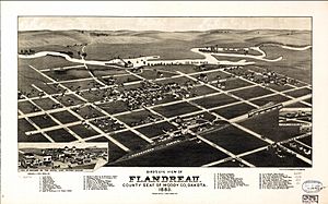
The town of Flandreau was first settled in 1857. It was named after Charles E. Flandrau. The settlement was left empty for a short time. This happened because the Yankton Sioux tribe was trying to protect their land.
In 1869, after the American Civil War, about 25 families of Christianized Santee Sioux people moved back to the area. More settlers arrived in 1872. When Moody County was officially formed in 1873, Flandreau became its main city.
Later, a school for Native American children was started in Flandreau. It was first called the Riggs Institute and opened in 1892. Today, it is known as the Flandreau Indian School. It is run by the Bureau of Indian Education.
Important places
The Flandreau Indian Reservation is located in this area. It is home to the Santee Sioux people.
Schools in Flandreau
Flandreau has public schools run by the state, known as Flandreau School District 50-3.
The Flandreau Indian School is also in the area. It is a special boarding school for Native American students.
Famous people from Flandreau
Some notable people have come from Flandreau:
- Gene Amdahl (1922-2015) - A computer expert known for "Amdahl's Law."
- Dell L. Dailey - An American military officer.
- Roger W. Hunt (1938-2018) - A politician from South Dakota.
- Bill Janklow (1939-2012) - A politician who served as South Dakota's Attorney General and Governor.
Images for kids
-
Location in Moody County and the state of South Dakota
See also
 In Spanish: Flandreau (Dakota del Sur) para niños
 | Emma Amos |
 | Edward Mitchell Bannister |
 | Larry D. Alexander |
 | Ernie Barnes |


