Trosky, Minnesota facts for kids
Quick facts for kids
Trosky, Minnesota
|
|
|---|---|

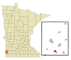
Location of Trosky, Minnesota
|
|
| Country | United States |
| State | Minnesota |
| County | Pipestone |
| Platted | September 1884 |
| Incorporated | June 10, 1893 |
| Government | |
| • Type | Mayor – Council |
| Area | |
| • Total | 1.409 sq mi (3.650 km2) |
| • Land | 1.409 sq mi (3.650 km2) |
| • Water | 0.100 sq mi (0.251 km2) |
| Elevation | 1,657 ft (505 m) |
| Population
(2020)
|
|
| • Total | 98 |
| • Estimate
(2022)
|
103 |
| • Density | 69.55/sq mi (26.85/km2) |
| Time zone | UTC−6 (Central (CST)) |
| • Summer (DST) | UTC−5 (CDT) |
| ZIP Code |
56144
|
| Area code(s) | 507 |
| FIPS code | 27-65542 |
| GNIS feature ID | 2397058 |
| Sales tax | 6.875% |
Trosky is a small city located in Pipestone County, Minnesota, United States. In 2020, about 98 people lived there.
Contents
History of Trosky
Trosky was first planned out in 1884. When a town is "platted," it means its streets and lots are officially mapped. The exact reason for the name Trosky is not fully known. A post office has been open in Trosky since 1884. Trosky officially became a city on June 10, 1893.
Geography of Trosky
Trosky is located in the state of Minnesota. According to the United States Census Bureau, the city covers a total area of about 1.409 square miles (3.650 square kilometers). All of this area is land.
Population Changes in Trosky
The number of people living in Trosky has changed over many years. Here is a look at the population from 1900 to 2020.
| Historical population | |||
|---|---|---|---|
| Census | Pop. | %± | |
| 1900 | 215 | — | |
| 1910 | 181 | −15.8% | |
| 1920 | 177 | −2.2% | |
| 1930 | 130 | −26.6% | |
| 1940 | 167 | 28.5% | |
| 1950 | 140 | −16.2% | |
| 1960 | 122 | −12.9% | |
| 1970 | 109 | −10.7% | |
| 1980 | 113 | 3.7% | |
| 1990 | 120 | 6.2% | |
| 2000 | 116 | −3.3% | |
| 2010 | 86 | −25.9% | |
| 2020 | 98 | 14.0% | |
| 2022 (est.) | 103 | 19.8% | |
| U.S. Decennial Census 2020 Census |
|||
Trosky's Population in 2010
In 2010, the city of Trosky had 86 people living there. These people lived in 39 households, and 29 of these were families. The city had about 52 people per square mile. There were 42 homes in total.
Most of the people in Trosky were White (95.3%). A small number were Native American (1.2%) or Asian (3.5%).
- About 25.6% of households had children under 18.
- Most households (64.1%) were married couples living together.
- A small number of households had a female head (7.7%) or a male head (2.6%) without a spouse.
- About 25.6% of households were not families.
- Many households (25.6%) had only one person living there.
- About 10.3% of households had someone aged 65 or older living alone.
- The average household had 2.21 people.
- The average family had 2.55 people.
The average age of people in Trosky was 46.5 years.
- 20.9% of residents were under 18.
- 2.4% were between 18 and 24.
- 25.6% were between 25 and 44.
- 36% were between 45 and 64.
- 15.1% were 65 years or older.
The city's population was 47.7% male and 52.3% female.
See also
 In Spanish: Trosky (Minnesota) para niños
 | William Lucy |
 | Charles Hayes |
 | Cleveland Robinson |

