Chandler, Minnesota facts for kids
Quick facts for kids
Chandler, Minnesota
|
|
|---|---|

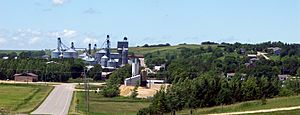
A view (from the east) of a portion of Chandler
|
|
| Motto(s):
"In God we trust"
|
|

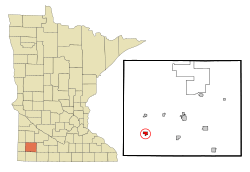
Location in Murray County and the state of Minnesota
|
|
| Country | United States |
| State | Minnesota |
| County | Murray |
| Government | |
| • Type | Mayor − Council |
| Area | |
| • Total | 0.79 sq mi (2.05 km2) |
| • Land | 0.79 sq mi (2.05 km2) |
| • Water | 0.00 sq mi (0.00 km2) |
| Elevation | 1,693 ft (516 m) |
| Population
(2020)
|
|
| • Total | 279 |
| • Density | 352.72/sq mi (136.20/km2) |
| Time zone | UTC-6 (Central (CST)) |
| • Summer (DST) | UTC-5 (CDT) |
| ZIP code |
56122
|
| Area code(s) | 507 |
| FIPS code | 27-10900 |
| GNIS feature ID | 2393798 |
Chandler is a small town located in Murray County, Minnesota, in the United States. In 2020, about 279 people lived there.
You can reach Chandler using these main roads:
- MN-91
- Murray County Highway 4
- Murray County Highway 103
- Murray County Highway 5
Contents
History of Chandler
A post office has been open in Chandler since 1886. The town was named after John Alonzo Chandler, who worked for the railroad.
From 1951 to 1969, a special air force base called Chandler Air Force Station was located just south of town. It was home to the 787th Aircraft Control and Warning Squadron.
On June 16, 1992, a very powerful tornado hit Chandler. It destroyed half of the town. Luckily, most of the town has been rebuilt since then.
In 2007, the Fenton Wind Farm started working near Chandler. This farm has 137 wind turbines that help create electricity.
Geography of Chandler
Chandler is in the southwestern part of Murray County. It is surrounded by different townships like Moulton, Fenton, Leeds, and Chanarambie.
Minnesota State Highway 91 runs through the east side of Chandler. This highway goes north about 5 miles to Lake Wilson. It also goes south about 20 miles to Adrian. Slayton, which is the main city for Murray County, is about 13 miles northeast.
The U.S. Census Bureau says that Chandler covers about 0.79 square miles of land. There is no water area within the town limits. Chanarambie Creek flows through the south side of Chandler. It eventually connects to the Big Sioux River.
Economy and Businesses
Chandler has several important companies that help the town's economy.
Some of the main businesses are:
- Monogram Foods: This company makes food products.
- Chandler Feed: They provide food for farm animals and special services for farming in Southwest Minnesota. They have other locations in nearby towns like Edgerton and Pipestone.
- Chandler Co-op: This business also helps with farming services. They have gas stations and stores, and they can fix vehicles too.
Other businesses in Chandler include Schurr Concrete, State Bank Of Chandler, Chandler State Agency, Action Signs and Billboards, and Chandler Machine Shop.
Population Information
| Historical population | |||
|---|---|---|---|
| Census | Pop. | %± | |
| 1910 | 225 | — | |
| 1920 | 272 | 20.9% | |
| 1930 | 250 | −8.1% | |
| 1940 | 363 | 45.2% | |
| 1950 | 331 | −8.8% | |
| 1960 | 388 | 17.2% | |
| 1970 | 319 | −17.8% | |
| 1980 | 344 | 7.8% | |
| 1990 | 316 | −8.1% | |
| 2000 | 276 | −12.7% | |
| 2010 | 270 | −2.2% | |
| 2020 | 279 | 3.3% | |
| U.S. Decennial Census | |||
Chandler's Population in 2010
According to the census from 2010, there were 270 people living in Chandler. These people lived in 109 households, and 75 of those were families.
Most of the people living in Chandler were White (88.9%). About 9.6% were from other races. Also, 22.6% of the population identified as Hispanic or Latino.
In 2010, about 32.1% of households had children under 18 living with them. Most households (57.8%) were married couples living together. About 26.6% of all households had only one person living in them.
The average age of people in Chandler was 41 years old. About 24.1% of residents were under 18. Also, 22.2% were 65 years old or older. The town had a nearly equal number of males (50.4%) and females (49.6%).
See also
 In Spanish: Chandler (Minnesota) para niños
 | Dorothy Vaughan |
 | Charles Henry Turner |
 | Hildrus Poindexter |
 | Henry Cecil McBay |

