Cottonwood River (Minnesota) facts for kids
Quick facts for kids Cottonwood River |
|
|---|---|

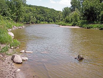
The Cottonwood River in Flandrau State Park in 2007
|
|
 |
|
| Country | United States |
| State | Minnesota |
| Physical characteristics | |
| Main source | Coteau des Prairies Rock Lake Township, Lyon County 1,653 ft (504 m) 44°12′06″N 95°56′06″W / 44.20167°N 95.93500°W |
| River mouth | Minnesota River near New Ulm, Brown County 794 ft (242 m) 44°17′05″N 94°24′55″W / 44.28472°N 94.41528°W |
| Length | 152.4 mi (245.3 km) |
| Basin features | |
| Basin size | 1,313 sq mi (3,400 km2) |
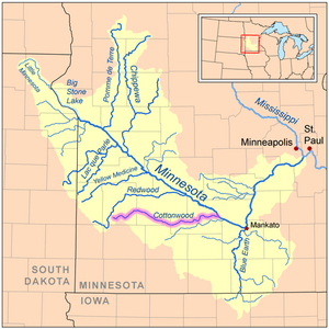
The Cottonwood River is a river in southwestern Minnesota, United States. It flows for about 152 miles (245 km). This river is a tributary, which means it's a smaller river that flows into a larger one. The Cottonwood River joins the Minnesota River. From there, its water eventually reaches the Mississippi River.
The river's name comes from the Sioux language. The Sioux people called it Waraju. This name refers to the Eastern cottonwood tree, which grows a lot along rivers in prairie areas. Sometimes, people used to call it the Big Cottonwood River.
Contents
The River's Journey
The Cottonwood River generally flows towards the east. It starts as a small, sometimes dry, stream southwest of Balaton. This area is in Lyon County. It begins on a high, flat land called the Coteau des Prairies. This plateau separates the areas that drain into the Mississippi River from those that drain into the Missouri River.
From Plateau to Plains
As the river leaves the Coteau, it flows through a wooded valley. In just five miles (3 km), it drops about 200 feet (60 m). Then, it enters a flatter area known as till plains. It flows through parts of Redwood County, Cottonwood County, and Brown County. Along its path, it passes by towns like Sanborn and Springfield.
Reaching the Minnesota River
Near its end, the Cottonwood River enters another wooded valley. It flows through Flandrau State Park. Finally, it joins the Minnesota River just southeast of New Ulm.
There used to be a dam on the river in Flandrau State Park. This dam created a lake. However, big floods in 1965 and 1969 washed the dam away. It was never rebuilt after that.
River Branches and Surroundings
The Cottonwood River does not have many smaller rivers joining it from the north. This is because of the way the land slopes. Also, there is a ridge of land called a terminal moraine along its northern side.
Main Tributaries
The biggest river joining the Cottonwood from the north is Sleepy Eye Creek. It is about 51 miles (82 km) long. This creek flows through Redwood and Brown Counties. It passes near Cobden.
From the south, the Cottonwood River gets more water.
- Plum Creek is about 35 miles (56 km) long. It flows through Murray and Redwood Counties, past Walnut Grove.
- Dutch Charley Creek is about 46 miles (74 km) long. It flows through Murray, Cottonwood, and Redwood Counties.
Land Use Around the River
Most of the land around the Cottonwood River is used for farming. About 84% of the land in its watershed is used for agriculture. The main crops grown here are corn and soybeans.
Many wetlands in this area have been drained for farming. Less than 4,000 acres (16 km²) of wetlands are left today.
River Flow and Water Levels
Scientists measure how much water flows in the Cottonwood River. The United States Geological Survey has a special station near New Ulm. This station is about 3.2 miles (5.2 km) from where the river meets the Minnesota River.
Between 1909 and 2005, the river's average flow was about 381 cubic feet per second (11 m³/s).
- The highest flow ever recorded was 28,700 cubic feet per second (813 m³/s). This happened on April 10, 1969.
- The lowest flow recorded was only 0.5 cubic feet per second (0 m³/s). This happened on November 27, 1952.
See also
 In Spanish: Río Cottonwood para niños
 | Laphonza Butler |
 | Daisy Bates |
 | Elizabeth Piper Ensley |

