Comfrey, Minnesota facts for kids
Quick facts for kids
Comfrey
|
|
|---|---|
| Motto(s):
"Remembering Yesterday, Appreciating Today, Working for Tomorrow"
|
|

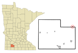
Location of Comfrey, Minnesota
|
|
| Country | United States |
| State | Minnesota |
| Counties | Brown, Cottonwood |
| platted | 1902 |
| Government | |
| • Type | Mayor - Council |
| Area | |
| • Total | 0.43 sq mi (1.11 km2) |
| • Land | 0.43 sq mi (1.11 km2) |
| • Water | 0.00 sq mi (0.00 km2) |
| Elevation | 1,125 ft (343 m) |
| Population
(2020)
|
|
| • Total | 392 |
| • Density | 915.89/sq mi (353.58/km2) |
| Time zone | UTC-6 (Central (CST)) |
| • Summer (DST) | UTC-5 (CDT) |
| ZIP code |
56019
|
| Area code(s) | 507 |
| FIPS code | 27-12772 |
| GNIS feature ID | 2393615 |
| Website | https://www.comfreymn.com/ |
Comfrey is a small city in Minnesota, a state in the United States. It is located in both Brown and Cottonwood counties. Most of its residents live in Brown County. In 2020, about 392 people called Comfrey home.
Contents
History of Comfrey
Comfrey was officially planned out and marked on a map in 1902. It was named by its first postmaster, A. W. Pederson. He chose the name after a plant called comfrey (Symphytini Officinalis).
On March 29, 1998, a very strong tornado hit Comfrey. This tornado was an F4, which means it was very powerful. It damaged or destroyed most of the buildings in the town. Luckily, no one was killed, but about a dozen people were hurt.
Comfrey's Geography
Comfrey covers a total area of about 0.47 square miles (1.11 square kilometers). All of this area is land. There are no large bodies of water within the city limits.
Comfrey's Population
| Historical population | |||
|---|---|---|---|
| Census | Pop. | %± | |
| 1910 | 238 | — | |
| 1920 | 533 | 123.9% | |
| 1930 | 535 | 0.4% | |
| 1940 | 555 | 3.7% | |
| 1950 | 642 | 15.7% | |
| 1960 | 616 | −4.0% | |
| 1970 | 525 | −14.8% | |
| 1980 | 548 | 4.4% | |
| 1990 | 433 | −21.0% | |
| 2000 | 367 | −15.2% | |
| 2010 | 382 | 4.1% | |
| 2020 | 392 | 2.6% | |
| U.S. Decennial Census | |||
What the 2010 Census Showed
In 2010, the city of Comfrey had 382 people living there. These people lived in 169 households, and 110 of these were families. The city had about 813 people per square mile.
Most of the people in Comfrey were White (97.1%). A small number were African American (0.3%) or from two or more races (2.6%). About 1.6% of the population identified as Hispanic or Latino.
About 28.4% of households had children under 18 living with them. Many households (56.2%) were married couples. About 20.2% of households had someone living alone who was 65 years old or older. The average household had 2.26 people.
The average age of people in Comfrey was 44.4 years old. About 23.3% of residents were under 18. About 24.9% were 65 years old or older. The population was almost evenly split between males (49.5%) and females (50.5%).
Arts and Culture in Comfrey
Museums and Interesting Places
The Jeffers Petroglyphs Historic Site is a special place located close to Comfrey. Petroglyphs are ancient rock carvings. These carvings were first found in the 1870s. Scientists and archeologists have visited them to study their history. In 1966, the Minnesota Historical Society bought the land. This was done to protect the petroglyphs for future generations to see and learn from.
Parks and Recreation
Mound Creek Park is a large park located a few miles outside of Comfrey. This park covers 316 acres of land. It was officially opened in 1993, offering a place for outdoor activities.
Education in Comfrey
Comfrey Public School teaches about 170 students. These students range from kindergarten all the way to 12th grade. The school building was badly damaged by the tornado in 1998. It was rebuilt and opened again in 1999.
Notable Person from Comfrey
- Glen Taylor is a very successful businessman. He owns the Minnesota Timberwolves and Minnesota Lynx basketball teams. He grew up on a farm just outside of Comfrey.
See also
 In Spanish: Comfrey (Minnesota) para niños
 | James B. Knighten |
 | Azellia White |
 | Willa Brown |

