Watonwan River facts for kids
Quick facts for kids Watonwan River |
|
|---|---|

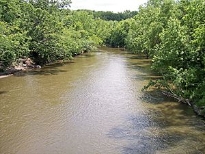
The Watonwan River in Garden City in 2007
|
|

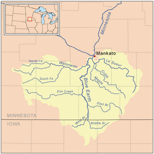
Map of the Blue Earth River watershed showing the Watonwan River
|
|
| Country | United States |
| State | Minnesota |
| Counties | Cottonwood, Watonwan, Blue Earth |
| Physical characteristics | |
| Main source | Amboy Township, Cottonwood County 1,529 ft (466 m) 44°01′30″N 95°13′12″W / 44.02500°N 95.22000°W |
| River mouth | Blue Earth River Rapidan Township, Blue Earth County 879 ft (268 m) 44°04′13″N 94°07′35″W / 44.07028°N 94.12639°W |
| Length | 113.2 mi (182.2 km) |
| Basin features | |
| Basin size | 878 sq mi (2,270 km2) |
| Tributaries |
|
The Watonwan River is a river in southern Minnesota, United States. It is about 113 miles (182 km) long. The word "Watonwan" comes from the Dakota language. It means "fish bait" or "plenty of fish."
This river is a tributary of the Blue Earth River. A tributary is a smaller river that flows into a larger one. The Watonwan River is part of a huge watershed that eventually leads to the Mississippi River. A watershed is an area of land where all the water drains into a specific river or lake. This river helps drain about one-fourth of the Blue Earth River's watershed.
In 1876, a famous event happened near Madelia on the river. Three members of the James–Younger Gang, Bob, Cole, and Jim Younger, were captured there.
Contents
Where Does the Watonwan River Flow?
The Watonwan River starts in Cottonwood County. This is about 3 miles (5 km) southwest of Jeffers. From there, it flows mostly east. It crosses flat plains through Watonwan and Blue Earth counties. The river passes by the city of Madelia.
The Watonwan River then joins the Blue Earth River. This meeting point is about 8 miles (13 km) southwest of Mankato. It is also about 16 miles (26 km) before the Blue Earth River flows into the Minnesota River.
River Branches: North and South Forks
The Watonwan River has two main branches. These are called its forks.
- The South Fork Watonwan River is about 73 miles (117 km) long. It begins in southeastern Cottonwood County. It flows east into Watonwan County, briefly touching Martin County. It passes Odin before turning northeast. It joins the main Watonwan River near Madelia.
- The North Fork Watonwan River is about 39 miles (63 km) long. It starts in Cottonwood County and flows east. It joins the Watonwan River about a mile (2 km) southeast of La Salle.
Watonwan River and Its Surroundings
Most of the land around the Watonwan River is used for farming. About 84% of the larger Blue Earth River watershed, which includes the Watonwan, is farmland. Farmers mainly grow corn and soybeans here.
Small lakes and wetlands near the Watonwan River are important homes for waterfowl. Waterfowl are birds like ducks and geese. However, many parts of the river have been changed by humans. This includes digging ditches and straightening the river. These changes help with farming and reduce local floods.
How Fast Does the River Flow?
Scientists measure how much water flows in the Watonwan River. They use a special tool called a stream gauge. This gauge is located near Garden City, about 7.3 miles (12 km) from where the river meets the Blue Earth River.
Between 1940 and 2005, the river's average flow was 391 cubic feet per second (11 cubic meters per second). The highest flow ever recorded was 13,900 cubic feet per second (394 cubic meters per second). This happened on June 20, 1993. The lowest flow was 1.8 cubic feet per second (0 cubic meters per second). This low flow was caused by an ice dam on December 24, 1989.
 | Stephanie Wilson |
 | Charles Bolden |
 | Ronald McNair |
 | Frederick D. Gregory |


