
Blue Earth River facts for kids
Quick facts for kids Blue Earth River |
|
|---|---|

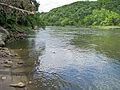
The Blue Earth River as viewed from Rapidan Dam in Blue Earth County in 2007
|
|
 |
|
| Other name(s) | Makhátho Wakpá, Makato Osa Watapa |
| Country | United States |
| State | Iowa, Minnesota |
| Physical characteristics | |
| Main source | Middle Branch Blue Earth River near Rake, Winnebago County, Iowa 1,207 ft (368 m) 43°27′30″N 93°48′04″W / 43.45833°N 93.80111°W |
| 2nd source | West Branch Blue Earth River near Swea City, Kossuth County, Iowa 1,152 ft (351 m) 43°24′13″N 94°17′38″W / 43.40361°N 94.29389°W |
| River mouth | Minnesota River Mankato, Blue Earth County, Minnesota 765 ft (233 m) 44°09′51″N 94°02′13″W / 44.16417°N 94.03694°W |
| Length | 108 mi (174 km) |
| Basin features | |
| Basin size | 3,486 sq mi (9,030 km2) |
| Tributaries |
|

The Blue Earth River (Dakota: Makhátho Wakpá) is a river in the southern part of Minnesota, United States. It flows for about 108 miles (174 km) and is a major tributary of the Minnesota River. Parts of its starting branches also flow through northern Iowa.
The Blue Earth River is the biggest tributary to the Minnesota River by how much water it carries. It provides almost half of the Minnesota River's water where they meet in Mankato. The river is part of the larger Mississippi River watershed. This means its water eventually flows into the Mississippi River. The river's watershed, or the land area it drains, is about 3,486 square miles (9,030 km2). Most of this area is farmland. The Blue Earth River is also a special "Water Trail" recognized by the Minnesota Department of Natural Resources.
Contents
Why is it Called the Blue Earth River?
The river gets its name from special bluish-green clay that used to be found along its banks. The Sisseton Dakota people called it Makato Osa Watapa, which means "the river where blue earth is gathered." They used this clay for body painting.
In the year 1700, a French explorer named Pierre-Charles Le Sueur built a fort called Fort L'Huillier near where the river meets the Minnesota River. He wanted to mine this blue clay. Some people think he believed the clay had copper in it. Others think he just pretended it did to get money for his fur trade business. The fort was attacked by the Fox tribe and abandoned the next year.
Later, in the 1800s, a geographer named Joseph Nicollet explored the area. He found places where Native Americans had dug up the clay. However, he didn't find any proof of Le Sueur's mines or his fort.
Where Does the Blue Earth River Flow?
The Blue Earth River starts in southwestern Faribault County, Minnesota. It forms where two smaller rivers, the Middle Branch Blue Earth River and the West Branch Blue Earth River, join together. This is about five miles (8.0 km) north of Elmore.
- The Middle Branch is about 35.1 miles (56.5 km) long. It starts in northwestern Winnebago County, Iowa. It flows west, then north, into Faribault County.
- The West Branch is about 24.7 miles (39.8 km) long. It starts near Swea City, Iowa. It flows northeast into Faribault County.
- Many parts of these two starting branches have been straightened by engineers.
From where its branches meet, the Blue Earth River flows north in a winding path. It goes through eastern Faribault County and then into Blue Earth County. Along its way, it passes by cities like Blue Earth, Winnebago, and Vernon Center. Finally, it reaches Mankato, where it flows into the Minnesota River.
Rapidan Dam
About 12 miles (19 km) before the Blue Earth River reaches the Minnesota River, there's a dam called Rapidan Dam. It was built in 1910 to create hydroelectricity (power from water). After it was built, the area behind the dam quickly filled up with silt and mud. The power plant was stopped for a while but started working again in 1984.
Main Tributaries
The Blue Earth River has several important rivers that flow into it. These are called tributaries.
- The Le Sueur River joins the Blue Earth River about 3 miles (5 km) before it meets the Minnesota River.
- The Watonwan River joins about 16 miles (26 km) upstream from the mouth.
These two rivers drain a large part of the Blue Earth River's watershed.
Other tributaries include:
- The East Branch Blue Earth River, which is 59.2 miles (95.3 km) long.
- Elm Creek, which is 89.5 miles (144.0 km) long.
The River's Surroundings
Most of the Blue Earth River flows through flat plains that were shaped by ancient glacial lakes and glaciers. The northern part of the river's watershed used to be covered by a large forest called the Big Woods. Today, most of this forest has been cleared for farming. However, some parts of the forest still remain along the riverbanks.
Below the Rapidan Dam, the river flows through a wooded valley. This part of the river is a popular spot for canoeing.
How is the River Doing Today?
The Minnesota Pollution Control Agency says that about 84% of the land around the Blue Earth River is used for farming. Farmers mostly grow corn and soybeans.
Because of this farming, the river faces some challenges. It is one of the most polluted rivers in Minnesota. It has high levels of:
- sediment (dirt and soil)
- bacteria
- nitrates and phosphorus (from fertilizers)
- mercury
- PCBs
- pesticides
These pollutants often come from surface runoff (water flowing over the land) in the farming areas. For example, fecal coliforms (a type of bacteria) are often found in the river. These can come from manure fertilizers, animal waste, or old septic tanks and sewer systems. The levels of these bacteria are sometimes too high for safe swimming.
How Much Water Flows in the River?
The United States Geological Survey (USGS) has a special station below the Rapidan Dam that measures how much water flows in the Blue Earth River. This station is about 12 miles (19 km) upstream from where the river meets the Minnesota River.
Between 1909 and 2005, the river's average flow at this station was about 1,076 cubic feet per second (30 m³/s).
- The most water ever recorded flowing was 43,100 ft³/s (1,220 m³/s) on April 9, 1965.
- The least water recorded was 6.9 ft³/s (0.2 m³/s) on October 12, 1955.
Related pages
Images for kids
-
The Blue Earth River near the USGS stream gauge in 2007

